Worland, Wyoming facts for kids
Quick facts for kids
Worland, Wyoming
|
||
|---|---|---|

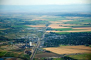
Aerial view of Worland, August 2011
|
||
|
||

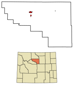
Location of Worland in Washakie County, Wyoming.
|
||
| Country | United States | |
| State | Wyoming | |
| County | Washakie | |
| Settled | 1900 | |
| Incorporated | 1906 | |
| Area | ||
| • Total | 4.64 sq mi (12.02 km2) | |
| • Land | 4.59 sq mi (11.88 km2) | |
| • Water | 0.06 sq mi (0.14 km2) 1.72% | |
| Elevation | 4,065 ft (1,239 m) | |
| Population
(2020)
|
||
| • Total | 4,773 | |
| • Estimate
(2023)
|
4,785 | |
| • Density | 1,095.27/sq mi (422.89/km2) | |
| Time zone | UTC−7 (Mountain) | |
| • Summer (DST) | UTC−6 (Mountain) | |
| ZIP code |
82401
|
|
| Area code(s) | 307 | |
| FIPS code | 56-84925 | |
| GNIS feature ID | 1596624 | |
Worland is a city in Washakie County, Wyoming, United States. It's the main city of Washakie County. Worland is found in the Big Horn Basin area. It sits right next to the Big Horn River in northwest Wyoming. In 2020, about 4,773 people lived here.
Contents
Worland's Population History
| Historical population | |||
|---|---|---|---|
| Census | Pop. | %± | |
| 1910 | 265 | — | |
| 1920 | 1,225 | 362.3% | |
| 1930 | 1,461 | 19.3% | |
| 1940 | 2,710 | 85.5% | |
| 1950 | 4,202 | 55.1% | |
| 1960 | 5,806 | 38.2% | |
| 1970 | 5,055 | −12.9% | |
| 1980 | 6,391 | 26.4% | |
| 1990 | 5,742 | −10.2% | |
| 2000 | 5,250 | −8.6% | |
| 2010 | 5,487 | 4.5% | |
| 2020 | 4,773 | −13.0% | |
People Living in Worland (2010)
In 2010, the city of Worland had 5,487 people. There were 2,310 homes. Most people were White (about 90%). About 17% of the people were Hispanic or Latino.
About 25% of the people were under 18 years old. The average age in the city was 39.8 years.
Worland's Location and Climate
Worland is located on the Big Horn River. It is in the Big Horn Basin area of Wyoming. The city covers about 4.64 square miles (12.02 square kilometers). Most of this area is land.
Worland's Weather
Worland is in a special spot. Mountains surround it, protecting it from bad weather. This means Worland has very dry and cold winters. There is not much wind, rain, or many storms. In fact, Worland is the least windy city in Wyoming!
Worland has a cool semi-arid climate. This means it's usually dry and cool. The hottest temperature ever recorded in Worland was 109°F (43°C). This happened in June and July 2021. The coldest temperature was -51°F (-46°C) in January 1930 and February 1936.
| Climate data for Worland, Wyoming, 1991-2020 normals, extremes 1907-present | |||||||||||||
|---|---|---|---|---|---|---|---|---|---|---|---|---|---|
| Month | Jan | Feb | Mar | Apr | May | Jun | Jul | Aug | Sep | Oct | Nov | Dec | Year |
| Record high °F (°C) | 63 (17) |
72 (22) |
81 (27) |
89 (32) |
96 (36) |
109 (43) |
109 (43) |
107 (42) |
102 (39) |
91 (33) |
79 (26) |
68 (20) |
109 (43) |
| Mean maximum °F (°C) | 48.5 (9.2) |
54.0 (12.2) |
71.0 (21.7) |
80.9 (27.2) |
88.7 (31.5) |
98.0 (36.7) |
102.3 (39.1) |
100.3 (37.9) |
95.1 (35.1) |
82.5 (28.1) |
65.8 (18.8) |
51.7 (10.9) |
103.0 (39.4) |
| Mean daily maximum °F (°C) | 30.6 (−0.8) |
36.8 (2.7) |
51.1 (10.6) |
60.2 (15.7) |
70.0 (21.1) |
81.6 (27.6) |
91.2 (32.9) |
89.0 (31.7) |
77.1 (25.1) |
61.1 (16.2) |
44.8 (7.1) |
32.1 (0.1) |
60.5 (15.8) |
| Daily mean °F (°C) | 17.2 (−8.2) |
23.3 (−4.8) |
36.8 (2.7) |
45.9 (7.7) |
56.2 (13.4) |
66.2 (19.0) |
73.9 (23.3) |
71.2 (21.8) |
60.2 (15.7) |
46.4 (8.0) |
31.3 (−0.4) |
19.4 (−7.0) |
45.7 (7.6) |
| Mean daily minimum °F (°C) | 3.9 (−15.6) |
9.8 (−12.3) |
22.5 (−5.3) |
31.5 (−0.3) |
42.4 (5.8) |
50.8 (10.4) |
56.6 (13.7) |
53.3 (11.8) |
43.3 (6.3) |
31.7 (−0.2) |
17.9 (−7.8) |
6.7 (−14.1) |
30.9 (−0.6) |
| Mean minimum °F (°C) | −16.0 (−26.7) |
−10.1 (−23.4) |
3.9 (−15.6) |
19.8 (−6.8) |
30.6 (−0.8) |
41.0 (5.0) |
48.8 (9.3) |
44.7 (7.1) |
32.7 (0.4) |
17.3 (−8.2) |
−1.2 (−18.4) |
−9.7 (−23.2) |
−22.0 (−30.0) |
| Record low °F (°C) | −51 (−46) |
−51 (−46) |
−26 (−32) |
−7 (−22) |
18 (−8) |
29 (−2) |
36 (2) |
32 (0) |
12 (−11) |
−11 (−24) |
−28 (−33) |
−44 (−42) |
−51 (−46) |
| Average precipitation inches (mm) | 0.28 (7.1) |
0.28 (7.1) |
0.47 (12) |
0.94 (24) |
1.80 (46) |
1.13 (29) |
0.69 (18) |
0.44 (11) |
1.03 (26) |
0.84 (21) |
0.46 (12) |
0.22 (5.6) |
8.58 (218.8) |
| Average snowfall inches (cm) | 5.1 (13) |
3.5 (8.9) |
4.7 (12) |
1.6 (4.1) |
0.4 (1.0) |
0.0 (0.0) |
0.0 (0.0) |
0.0 (0.0) |
1.5 (3.8) |
2.1 (5.3) |
4.4 (11) |
6.7 (17) |
30.0 (76) |
| Average precipitation days (≥ 0.01 in) | 4.7 | 5.0 | 5.2 | 7.5 | 9.8 | 7.6 | 5.8 | 4.8 | 6.2 | 6.3 | 5.1 | 4.7 | 72.7 |
| Average snowy days (≥ 0.1 in) | 4.4 | 3.4 | 3.5 | 1.4 | 0.4 | 0.0 | 0.0 | 0.0 | 0.5 | 1.3 | 3.4 | 5.1 | 23.4 |
| Source 1: National Weather Service | |||||||||||||
| Source 2: NOAA (average snowfall/snowy days 1981–2010) | |||||||||||||
Worland's Economy
Worland is an important business center for the Big Horn Basin. The city's economy relies on farming and drilling for oil and gas. Sugar beets are the most important farm product grown in the area.
Some of the biggest employers in Worland are Admiral Beverage, Wyoming Sugar Company, Crown Cork & Seal, and MillerCoors.
Education in Worland
Public schools in Worland are part of Washakie County School District #1. The district has five schools:
- East Side Elementary
- South Side Elementary
- West Side Elementary
- Worland Middle School
- Worland High School
Worland also has a public library. It is a branch of the Washakie County Library.
Getting Around Worland
Worland has its own airport, called Worland Municipal Airport.
Major roads also serve the city. These include U.S. Route 20 and U.S. Route 16. You can also find bus service from Express Arrow. The Worland Senior Center offers local rides on weekdays and Sundays.
See also
 In Spanish: Worland (Wyoming) para niños
 | Lonnie Johnson |
 | Granville Woods |
 | Lewis Howard Latimer |
 | James West |


