Ten Sleep, Wyoming facts for kids
Quick facts for kids
Ten Sleep, Wyoming
|
|
|---|---|

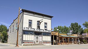
Downtown Ten Sleep, September 2014
|
|

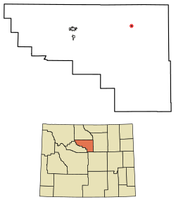
Location of Ten Sleep in Washakie County, Wyoming.
|
|
| Country | United States |
| State | Wyoming |
| County | Washakie |
| Area | |
| • Total | 0.18 sq mi (0.47 km2) |
| • Land | 0.18 sq mi (0.47 km2) |
| • Water | 0.00 sq mi (0.00 km2) |
| Elevation | 4,426 ft (1,349 m) |
| Population
(2010)
|
|
| • Total | 260 |
| • Estimate
(2019)
|
250 |
| • Density | 1,366.12/sq mi (528.00/km2) |
| Time zone | UTC-7 (Mountain (MST)) |
| • Summer (DST) | UTC-6 (MDT) |
| ZIP code |
82442
|
| Area code(s) | 307 |
| FIPS code | 56-75790 |
| GNIS feature ID | 1595354 |
| Website | http://www.townoftensleep.com/ |
Ten Sleep is a small town in Washakie County, Wyoming, United States. It is nestled in the Bighorn Basin. The town sits at the western base of the Bighorn Mountains. It's about 26 miles (42 km) east of Worland. It is also about 59 miles (95 km) west of Buffalo.
In 2020, the town had a population of 246 people.
Contents
Life and Activities in Ten Sleep
Ten Sleep is a friendly ranching community. It also has some other businesses like mining (for a material called bentonite) and tourism. There are a few small businesses that serve both locals and visitors. These include cafes, restaurants, motels, a historic hardware store, a campground, a bank, and a gas station.
The area is famous for its outdoor adventures. People enjoy hunting, fishing, and horseback riding. Many also come for rock climbing, kayaking, and mountain biking. You can even explore caves or ride off-highway vehicles. Kids often play in Ten Sleep Creek, which flows through town. They can catch trout or float down the creek on inner tubes in the summer.
Local Traditions and Events
Ten Sleep has fun annual celebrations. One big event is a two-day rodeo and parade around the 4th of July. The town gets very busy then, with many tourists and locals joining the fun. The main street closes for live music that plays late into the night.
Another yearly tradition is NoWoodStock. This music festival happens in August. It features different types of music like folk, bluegrass, jazz, and rock. People from all over the world come to enjoy the music.
Ten Sleep also has its own microbrewery. It's called Ten Sleep Brewing Company. They started making different kinds of beers in 2013.
Historic Places
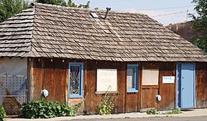
The Ten Sleep Mercantile store is a special place. It's also known as Ten Sleep Hardware. This building was built in 1905 and has been important to the town ever since. It's a great example of an old-fashioned general store. From 1919 to 1943, Paul Frison ran the store. He was also the mayor of Ten Sleep and a state lawmaker for Wyoming.
Near Ten Sleep Canyon was once a huge Girl Scout National Center West. Part of that land is now a nature preserve. It's run by the Nature Conservancy. They use it for workshops and learning events.
Geography and Climate
Ten Sleep is located at 44°2′5″N 107°26′53″W / 44.03472°N 107.44806°W. The town covers a total area of about 0.18 square miles (0.47 square kilometers). All of this area is land.
Weather in Ten Sleep
Ten Sleep has a climate with hot summers. The hottest temperature ever recorded was 105°F (41°C) on July 13, 2005. The coldest temperature was -34°F (-37°C) on December 22, 1990.
| Climate data for Ten Sleep, Wyoming, 1991–2020 normals, extremes 1964–present | |||||||||||||
|---|---|---|---|---|---|---|---|---|---|---|---|---|---|
| Month | Jan | Feb | Mar | Apr | May | Jun | Jul | Aug | Sep | Oct | Nov | Dec | Year |
| Record high °F (°C) | 64 (18) |
66 (19) |
79 (26) |
87 (31) |
91 (33) |
100 (38) |
105 (41) |
100 (38) |
98 (37) |
88 (31) |
74 (23) |
66 (19) |
105 (41) |
| Mean maximum °F (°C) | 52.7 (11.5) |
54.5 (12.5) |
66.7 (19.3) |
76.2 (24.6) |
83.9 (28.8) |
92.2 (33.4) |
96.8 (36.0) |
95.0 (35.0) |
90.6 (32.6) |
79.9 (26.6) |
64.9 (18.3) |
54.3 (12.4) |
97.4 (36.3) |
| Mean daily maximum °F (°C) | 36.8 (2.7) |
38.9 (3.8) |
50.9 (10.5) |
58.9 (14.9) |
68.7 (20.4) |
79.6 (26.4) |
88.2 (31.2) |
86.4 (30.2) |
76.2 (24.6) |
60.7 (15.9) |
46.1 (7.8) |
36.3 (2.4) |
60.6 (15.9) |
| Daily mean °F (°C) | 25.8 (−3.4) |
28.1 (−2.2) |
38.7 (3.7) |
46.2 (7.9) |
55.5 (13.1) |
65.0 (18.3) |
72.9 (22.7) |
71.1 (21.7) |
61.2 (16.2) |
47.6 (8.7) |
35.1 (1.7) |
25.8 (−3.4) |
47.8 (8.8) |
| Mean daily minimum °F (°C) | 14.7 (−9.6) |
17.2 (−8.2) |
26.5 (−3.1) |
33.6 (0.9) |
42.2 (5.7) |
50.5 (10.3) |
57.5 (14.2) |
55.7 (13.2) |
46.3 (7.9) |
34.6 (1.4) |
24.1 (−4.4) |
15.2 (−9.3) |
34.8 (1.6) |
| Mean minimum °F (°C) | −6.3 (−21.3) |
−2.3 (−19.1) |
8.7 (−12.9) |
20.8 (−6.2) |
29.6 (−1.3) |
39.1 (3.9) |
48.2 (9.0) |
44.9 (7.2) |
33.5 (0.8) |
19.4 (−7.0) |
4.0 (−15.6) |
−5.1 (−20.6) |
−13.3 (−25.2) |
| Record low °F (°C) | −28 (−33) |
−31 (−35) |
−15 (−26) |
5 (−15) |
20 (−7) |
31 (−1) |
38 (3) |
32 (0) |
15 (−9) |
−6 (−21) |
−16 (−27) |
−34 (−37) |
−34 (−37) |
| Average precipitation inches (mm) | 0.60 (15) |
0.65 (17) |
0.99 (25) |
1.54 (39) |
2.42 (61) |
1.62 (41) |
0.90 (23) |
0.66 (17) |
1.47 (37) |
1.38 (35) |
0.77 (20) |
0.71 (18) |
13.71 (348) |
| Average snowfall inches (cm) | 9.0 (23) |
9.5 (24) |
5.7 (14) |
5.4 (14) |
1.1 (2.8) |
0.0 (0.0) |
0.0 (0.0) |
0.0 (0.0) |
0.3 (0.76) |
3.5 (8.9) |
7.6 (19) |
9.5 (24) |
51.6 (130.46) |
| Average precipitation days (≥ 0.01 in) | 5.7 | 6.1 | 6.0 | 8.0 | 9.4 | 7.6 | 5.6 | 5.1 | 6.3 | 7.0 | 5.6 | 6.0 | 78.4 |
| Average snowy days (≥ 0.1 in) | 5.7 | 5.7 | 3.6 | 2.4 | 0.3 | 0.0 | 0.0 | 0.0 | 0.2 | 1.8 | 4.0 | 5.7 | 29.4 |
| Source 1: NOAA | |||||||||||||
| Source 2: National Weather Service | |||||||||||||
| Climate data for TenSleep 16 SSE, Wyoming, 1991–2020 normals, 1959-2020 extremes: 4680ft (1426m) | |||||||||||||
|---|---|---|---|---|---|---|---|---|---|---|---|---|---|
| Month | Jan | Feb | Mar | Apr | May | Jun | Jul | Aug | Sep | Oct | Nov | Dec | Year |
| Record high °F (°C) | 61 (16) |
66 (19) |
77 (25) |
85 (29) |
92 (33) |
100 (38) |
103 (39) |
103 (39) |
97 (36) |
88 (31) |
76 (24) |
65 (18) |
103 (39) |
| Mean maximum °F (°C) | 51.0 (10.6) |
53.8 (12.1) |
66.3 (19.1) |
75.8 (24.3) |
83.2 (28.4) |
91.4 (33.0) |
97.1 (36.2) |
95.1 (35.1) |
90.3 (32.4) |
79.4 (26.3) |
65.7 (18.7) |
54.0 (12.2) |
97.5 (36.4) |
| Mean daily maximum °F (°C) | 34.0 (1.1) |
36.4 (2.4) |
46.9 (8.3) |
55.0 (12.8) |
64.8 (18.2) |
76.4 (24.7) |
86.2 (30.1) |
84.2 (29.0) |
72.7 (22.6) |
58.0 (14.4) |
45.0 (7.2) |
34.7 (1.5) |
57.9 (14.4) |
| Daily mean °F (°C) | 17.4 (−8.1) |
20.9 (−6.2) |
32.9 (0.5) |
41.1 (5.1) |
50.9 (10.5) |
61.0 (16.1) |
69.0 (20.6) |
66.3 (19.1) |
55.4 (13.0) |
42.4 (5.8) |
29.5 (−1.4) |
18.6 (−7.4) |
42.1 (5.6) |
| Mean daily minimum °F (°C) | 0.8 (−17.3) |
5.3 (−14.8) |
18.9 (−7.3) |
27.2 (−2.7) |
37.0 (2.8) |
45.6 (7.6) |
51.7 (10.9) |
48.4 (9.1) |
38.1 (3.4) |
26.7 (−2.9) |
14.0 (−10.0) |
2.5 (−16.4) |
26.4 (−3.1) |
| Mean minimum °F (°C) | −23.8 (−31.0) |
−20.2 (−29.0) |
−1.5 (−18.6) |
13.5 (−10.3) |
24.6 (−4.1) |
34.2 (1.2) |
42.9 (6.1) |
38.7 (3.7) |
26.9 (−2.8) |
10.5 (−11.9) |
−9.2 (−22.9) |
−20.9 (−29.4) |
−30.8 (−34.9) |
| Record low °F (°C) | −45 (−43) |
−46 (−43) |
−26 (−32) |
−4 (−20) |
17 (−8) |
27 (−3) |
31 (−1) |
30 (−1) |
12 (−11) |
−22 (−30) |
−32 (−36) |
−51 (−46) |
−51 (−46) |
| Average precipitation inches (mm) | 0.59 (15) |
0.73 (19) |
1.12 (28) |
1.70 (43) |
2.31 (59) |
1.45 (37) |
0.97 (25) |
0.76 (19) |
1.25 (32) |
1.45 (37) |
0.83 (21) |
0.81 (21) |
13.97 (356) |
| Average snowfall inches (cm) | 10.20 (25.9) |
10.50 (26.7) |
9.40 (23.9) |
6.40 (16.3) |
0.90 (2.3) |
0.00 (0.00) |
0.00 (0.00) |
0.00 (0.00) |
0.30 (0.76) |
5.20 (13.2) |
8.60 (21.8) |
11.20 (28.4) |
62.7 (159.26) |
| Source 1: NOAA | |||||||||||||
| Source 2: XMACIS2 (records & monthly max/mins) | |||||||||||||
History of Ten Sleep
Ten Sleep got its name from Native American travelers. It was a common rest stop. The name "10 sleeps" meant it was a 10-day journey from several important places. These included Fort Laramie (to the southeast), Yellowstone National Park (to the west-northwest), and an Indian Agency in Montana (to the northwest).
Many old Native American sites are in the area. People often find artifacts like arrowheads, pictographs (rock paintings), and petroglyphs (rock carvings).
The Spring Creek Raid
Ten Sleep was also the site of the Spring Creek Raid. This event was one of the last big fights in the "Sheep and Cattlemen's War." In March 1909, cattlemen attacked sheep herders. They killed three men and shot hundreds of sheep. The people responsible were caught and punished. This event helped end the major conflicts. However, it took many more years for cattle and sheep ranchers to get along.
Geology and Fossils
The area around Ten Sleep is rich in ancient history. You can find fossils of dinosaurs, plants, and sea creatures. One place, Big Cedar Ridge, is open to the public. You can explore and collect fossils for your own use there.
Rock Formations
The yellowish-gray to white sandstone in Ten Sleep Canyon is called the Tensleep Formation. It makes up a lot of the western side of the Bighorn Mountains. The red sandstone, like Signal Cliff, is from the Chugwater Formation. This formation also forms the dirt hills along the western Bighorn Mountains.
Above the Chugwater Formation, you can find the Sundance Formation. This rock layer formed in the ocean. Then comes the Morrison Formation, which has dinosaur fossils. Locals sometimes call the Cloverly Formation the "Painted Desert" or "Colored Hills." It has fine sandstone, clay, and "gumbo" (a type of sticky clay). The Cloverly formations show bands of different mineral colors. These range from greens and grays to red and violets. They are often found with dinosaur fossils. Signs along U.S. 16 explain these different rock layers.
Population of Ten Sleep
| Historical population | |||
|---|---|---|---|
| Census | Pop. | %± | |
| 1940 | 345 | — | |
| 1950 | 289 | −16.2% | |
| 1960 | 314 | 8.7% | |
| 1970 | 320 | 1.9% | |
| 1980 | 407 | 27.2% | |
| 1990 | 311 | −23.6% | |
| 2000 | 304 | −2.3% | |
| 2010 | 260 | −14.5% | |
| 2019 (est.) | 250 | −3.8% | |
| U.S. Decennial Census | |||
Ten Sleep in 2020
The 2020 United States census counted 246 people living in Ten Sleep. There were 120 households and 76 families. Most people (97.56%) were white. About 19.5% of the population was under 18 years old. The average age in town was 52.5 years. For every 100 females, there were about 83.6 males.
Ten Sleep in 2010
In the census of 2010, Ten Sleep had 260 people. There were 133 households. About 17.3% of households had children under 18. The average age in town was 54.3 years. About 17.3% of residents were under 18. About 28.5% were 65 or older. There were more males (53.8%) than females (46.2%).
Education in Ten Sleep
Kids in Ten Sleep go to public schools run by Washakie County School District #2. Ten Sleep School serves students from kindergarten all the way through 12th grade. The town also has a public library. It is a part of the Washakie County Library system.
Notable People from Ten Sleep
- Jalan Crossland – a bluegrass singer and musician.
- Matt Foreman (activist) – an activist.
- Gerald "Jerry" Geis (born 1933) – He was the President of the Wyoming State Senate from 1985–1986. He served for a long time in the Wyoming State Senate. He also worked as a special economic helper to The Republic of China in the 1970s.
See also
 In Spanish: Ten Sleep para niños
 | Isaac Myers |
 | D. Hamilton Jackson |
 | A. Philip Randolph |


