
Shoshone River facts for kids
Quick facts for kids Shoshone River |
|
|---|---|

South Fork Shoshone River in Park County, Wyoming, 1923.
|
|

Map of the Bighorn River basin including the Shoshone River
|
|
| Native name | Aashilitshia, "Stinking River" Aashbikkaashée, "Grass Lodge [Shoshone] River" |
| Country | United States |
| State | Wyoming |
| Cities | Cody, Wyoming, Powell, Wyoming, Lovell, Wyoming |
| Physical characteristics | |
| Main source | Absaroka Range, Wyoming 44°30′04″N 109°11′02″W / 44.50111°N 109.18389°W |
| River mouth | Big Horn River Lovell, Wyoming 44°51′44″N 108°12′17″W / 44.86222°N 108.20472°W |
| Length | 100 mi (160 km) |
| Basin features | |
| Basin size | 2,989 sq mi (7,740 km2) |
The Shoshone River is a 100-mile (160 km) long river in northern Wyoming, United States. It starts high in the Absaroka Range mountains within the Shoshone National Forest. The river flows until it joins the Big Horn River near Lovell, Wyoming.
The Shoshone River passes by or through several towns. These include Cody, Powell, Byron, and Lovell.
Contents
Why the Shoshone River Was Called "Stinking Water"
Near the town of Cody, the Shoshone River flows through an area with volcanic activity. This area is known as Colter's Hell. Here, you can find fumaroles, which are vents that release steam and gases from the Earth. The smell from these gases made people call the river the Stinking Water River on old maps of Wyoming.
How the River Got Its Current Name
The name of the river was officially changed to Shoshone River in 1901. This change happened because many people wanted a new name.
Buffalo Bill Dam: A Big Project on the River

West of Cody, the Shoshone River is held back by the Buffalo Bill Dam. This dam is located in Shoshone Canyon. It was built as part of the Shoshone project, which was one of the first big water conservation projects in the United States.
How the Dam Changed the River
When the Buffalo Bill Dam was built, it created a large lake called Buffalo Bill Reservoir. This reservoir covered up several natural hot springs that were along the river.
Where the Shoshone River Begins
Upstream from the Buffalo Bill Reservoir, the Shoshone River splits into two main parts:
- The North Fork flows through a long canyon from the Absaroka Mountains. It goes all the way to the area near the east entrance of Yellowstone National Park.
- The South Fork starts at the southern end of the Absaroka Mountains.
Images for kids
-
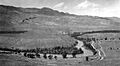
South Fork Shoshone River in Park County, Wyoming, 1923.
-
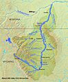
Map of the Bighorn River basin including the Shoshone River
