
Beartooth Highway facts for kids
Quick facts for kids
[[File:|x70px|alt= marker]] |
|
|---|---|
|
Beartooth Highway highlighted in red
|
|
| Route information | |
| Maintained by National Park Service | |
| Length | 68.7 mi (110.6 km) |
| Component highways |
|
| Major junctions | |
| West end | |
| East end | |
| Highway system | |
| Montana Highways | |

Approaching Beartooth Pass from the East along the Beartooth Highway
|
|
| Elevation | 10,947 ft (3,337 m) |
| Traversed by | |
| Location | Montana / Wyoming, United States |
| Range | Beartooth Mountains |
| Coordinates | 44°58.1′N 109°27.9′W / 44.9683°N 109.4650°W |
The Beartooth Highway is a super famous road in Montana and Wyoming. It's part of U.S. Route 212 and is known as an All-American Road. This means it's one of the most beautiful drives in the whole country!
The highway stretches between Red Lodge and the northeast entrance of Yellowstone National Park. It goes right over the Beartooth Pass in Wyoming. This pass is super high, reaching about 10,947 feet (3,337 meters) above sea level. A famous TV reporter, Charles Kuralt, even called it "the most beautiful drive in America." Because of how much snow falls up high, the highway is usually only open from mid-May to mid-October. This depends on the weather, of course!
Contents
What Makes the Beartooth Highway Special?
The Beartooth Highway is a section of U.S. Route 212. It connects Red Lodge, Montana to Cooke City, Montana. This road is famous for its many steep zigzags and sharp turns called switchbacks. These turns help the road climb up the Montana-Wyoming border.
Climbing to the Top
The highway climbs to the 10,947-foot (3,337-meter) Beartooth Pass in Wyoming. You go from about 5,200 feet (1,585 meters) to over 10,900 feet (3,322 meters) in just 12 miles (19 kilometers)! This makes for some truly amazing views.
As you drive from east to west, the highest parts of the highway flatten out. This creates a wide, open area near the top of the pass. Then, the road goes downhill towards Wyoming Highway 296. This road is also known as the Chief Joseph Scenic Byway. It's near Cooke City, which is a gateway town to Yellowstone National Park. Along the way, you'll see many beautiful lakes. These lakes are typical of the Absaroka-Beartooth Wilderness Area. This wilderness area runs alongside much of the highway.
The Beartooth Highway first opened to drivers on June 14, 1936.
Weather on the Pass
Even in the middle of summer, snowstorms can happen at this high altitude. The pass is also known for strong winds and big thunderstorms. If you plan to drive the 69-mile (111-kilometer) trip from Red Lodge to Cooke City, expect it to take at least two hours. It's a good idea to check with the Red Lodge Chamber of Commerce before you go. They can tell you if the road is open or if there are any closures. You can also find information online from Montana and Wyoming travel services.
The Beartooth Highway goes through parts of several national forests. These include Custer, Shoshone, and Gallatin national forests. It also passes near the Absaroka-Beartooth Wilderness.
Who Takes Care of the Road?
Even though it's a U.S. highway, the Beartooth Highway is special. It's not maintained by the Wyoming Department of Transportation. Instead, the National Park Service takes care of most of it. This is interesting because the highway isn't actually inside a national park. The Montana Department of Transportation does maintain the parts of the highway in Montana. This includes the sections in Custer and Gallatin national forests.
Neither the Montana Department of Transportation nor the National Park Service clear snow from the road all winter. They only do a big snow removal once in the spring. This usually happens in May, but sometimes it's as late as June if there's been a lot of snow. Once the road opens, the Beartooth Basin Ski Area opens too. It's right at the state line on Beartooth Pass. It's a unique ski area because it's only open for a short summer season, usually until July!
History of the Highway
The Beartooth Pass has a long history. In August 1872, a famous general from the American Civil War, Philip Sheridan, crossed the pass. He was with 120 men. They were returning from a trip to Yellowstone National Park. Instead of taking a long way around, General Sheridan followed advice from an old hunter. The hunter, Shuki Greer, knew the Beartooth Mountains very well. When the Beartooth Highway finally opened in 1936, it mostly followed the same path General Sheridan took.
Road Closures in 2005
In May 2005, the Beartooth Highway faced a big challenge. Several large mudslides and rockslides hit the Montana side of the road. This happened on May 19-20. The slides damaged or destroyed the highway in about a dozen places. These spots were between mile markers 39 and 51.
Because of the damage, the road had to close for repairs. A big construction project started, costing $20.4 million. The goal was to finish the work by October 2005. The construction crews worked very hard and finished ahead of schedule! However, the highway still didn't reopen for a whole year. Workers removed about 100,000 cubic yards (76,455 cubic meters) of rock. This was from a half-mile (0.8-kilometer) section near the top of the switchbacks. They also drilled deep into the solid rock to build new supports for the road.
Gallery
- Beartooth Highway
-
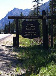
The sign marking the beginning of Beartooth Highway at the exit to Yellowstone National Park
-
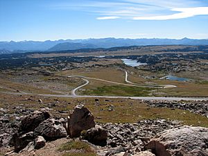
Beartooth Highway weaving its way through the Beartooth Mountains


Images for kids
-
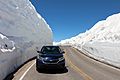
The Beartooth Highway after the snow is plowed in the spring.

