Cooke City-Silver Gate, Montana facts for kids
Quick facts for kids
Cooke City-Silver Gate, Montana
|
|
|---|---|
|
Former CDP
|
|

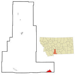
Location of Cooke City-Silver Gate, Montana
|
|
| Country | United States |
| State | Montana |
| County | Park |
| Area | |
| • Total | 10.0 sq mi (25.9 km2) |
| • Land | 10.0 sq mi (25.9 km2) |
| • Water | 0.0 sq mi (0.0 km2) |
| Elevation | 7,608 ft (2,318.9 m) |
| Population
(2000)
|
|
| • Total | 140 |
| • Density | 14.0/sq mi (5.4/km2) |
| Time zone | UTC-7 (Mountain (MST)) |
| • Summer (DST) | UTC-6 (MDT) |
| Area code(s) | 406 |
| FIPS code | 30-17359 |
Cooke City-Silver Gate was a special type of community in Park County, Montana, United States. It was known as a census-designated place (CDP). This means it was an area identified by the U.S. Census Bureau for statistical purposes. It included two smaller, separate communities: Cooke City and Silver Gate.
In the year 2000, about 140 people lived here. Later, for the 2010 census, Cooke City and Silver Gate were counted as two separate places. These communities are located near the northeast part of Yellowstone National Park, right along the famous Beartooth Highway.
Contents
Where is Cooke City-Silver Gate Located?
The Cooke City-Silver Gate area was found at specific geographic coordinates: 45.017378 degrees North and -109.938599 degrees West. It sits at a high elevation of 7,608 feet (which is about 2,318 meters) above sea level.
According to the United States Census Bureau, the total area of this CDP was about 10.0 square miles (or 25.9 square kilometers). All of this area was land, meaning there were no large bodies of water within its boundaries.
Who Lived in Cooke City-Silver Gate?
In the year 2000, the census showed that 140 people lived in Cooke City-Silver Gate. These people lived in 79 different homes, and 27 of those homes were families. The area had about 14 people per square mile. There were also 247 housing units, which means there were many places to live, even if not all were occupied.
Most of the people living there were White (about 97.86%). A small number were African American (0.71%), Native American (0.71%), or from two or more racial backgrounds (0.71%).
Homes and Families
Out of the 79 homes, about 11.4% had children under 18 years old living there. About 29.1% of homes were married couples living together. In 5.1% of homes, a female head of household lived without a husband. A large number, 65.8%, were not traditional families.
About 40.5% of all homes had just one person living in them. Around 11.4% of homes had someone living alone who was 65 years old or older. On average, each home had about 1.77 people, and each family had about 2.44 people.
Age and Income
The population in Cooke City-Silver Gate was spread out by age. About 8.6% of residents were under 18 years old. Around 4.3% were between 18 and 24. A large group, 42.1%, were between 25 and 44. Another big group, 35.0%, were between 45 and 64. Finally, 10.0% of the people were 65 years old or older. The average age of residents was 43 years.
For every 100 females, there were about 122.2 males. If we looked at adults aged 18 and over, for every 100 females, there were about 113.3 males.
The average income for a home in the area was $25,000 per year. For families, the average income was higher, at $50,625 per year. Males earned more on average ($38,125) than females ($17,813). The average income per person in the CDP was $31,618. About 7.4% of families and 15.8% of the total population lived below the poverty line. This included 18.2% of those under 18 and 10.5% of those over 64.
Images for kids
 | Toni Morrison |
 | Barack Obama |
 | Martin Luther King Jr. |
 | Ralph Bunche |


