
Cooke City, Montana facts for kids
Quick facts for kids
Cooke City, Montana
|
|
|---|---|

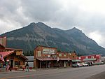
Entering Cooke City from the east
|
|

Cooke City, Montana
Location in Montana

Cooke City, Montana
Location in the United States
|
|
| Country | United States |
| State | Montana |
| County | Park |
| Area | |
| • Total | 9.54 sq mi (24.70 km2) |
| • Land | 9.54 sq mi (24.70 km2) |
| • Water | 0.00 sq mi (0.00 km2) |
| Elevation | 7,580 ft (2,310 m) |
| Population
(2020)
|
|
| • Total | 77 |
| • Density | 8.08/sq mi (3.12/km2) |
| Time zone | UTC-7 (Mountain (MST)) |
| • Summer (DST) | UTC-6 (MDT) |
| ZIP Code |
59020
|
| Area code(s) | 406 |
| FIPS code | 30-17350 |
| GNIS feature ID | 2583800 |
Cooke City is a small mountain community in Park County, Montana, United States. It is known as a "census-designated place" (CDP). This means it's a community that the government counts for population. However, it doesn't have its own city government like larger towns.
In 2020, about 77 people lived there. Before 2010, Cooke City was part of a larger area called Cooke City-Silver Gate.
Cooke City is located just northeast of Yellowstone National Park. It sits on the famous Beartooth Highway. This road goes east towards Red Lodge, Montana. It's a very scenic route that climbs high into the Beartooth Mountains. The town's main business is tourism. In winter, people come here for skiing and snowmobiling.
The town is named after Jay Cooke. He was a very important financier who helped fund the Northern Pacific Railroad.
Where is Cooke City?
Cooke City is found in the southeast part of Park County. To the south, it borders the North Absaroka Wilderness. This wilderness area is inside the Shoshone National Forest in Wyoming. To the west, you'll find the community of Silver Gate, Montana.
Both Cooke City and Silver Gate are in the valley of Soda Butte Creek. This creek flows southwest into Wyoming. It then joins the Lamar River inside Yellowstone National Park. This valley is part of the larger Yellowstone River area.
U.S. Route 212, also known as the Beartooth Highway, runs right through Cooke City. If you go southwest, it leads into Yellowstone National Park. If you go east, it crosses Colter Pass, which is over 8,040 feet (2,450 meters) high. The highway then continues into Wyoming, following the valley of the Clarks Fork Yellowstone River.
Weather in Cooke City
Cooke City has a very cold climate because it's so high up. It's located at about 7,580 feet (2,310 meters) above sea level. This type of climate is called a subarctic climate or a subalpine climate. Only two months of the year have average temperatures above 50°F (10°C).
Summers in Cooke City are usually mild or warm during the day. The mornings are often cool and crisp. Winters are very long and extremely cold. Temperatures often drop below zero degrees Fahrenheit. There is a lot of snow, mostly from October to May. Sometimes, snow can even fall in June and September. Cooke City is known as the snowiest place in Montana.
| Climate data for Cooke City, Montana, 1991–2020 normals, extremes 1946–2013 | |||||||||||||
|---|---|---|---|---|---|---|---|---|---|---|---|---|---|
| Month | Jan | Feb | Mar | Apr | May | Jun | Jul | Aug | Sep | Oct | Nov | Dec | Year |
| Record high °F (°C) | 48 (9) |
54 (12) |
58 (14) |
74 (23) |
80 (27) |
88 (31) |
100 (38) |
90 (32) |
86 (30) |
85 (29) |
60 (16) |
47 (8) |
100 (38) |
| Mean maximum °F (°C) | 37.8 (3.2) |
44.2 (6.8) |
51.4 (10.8) |
61.2 (16.2) |
71.1 (21.7) |
79.9 (26.6) |
84.9 (29.4) |
82.7 (28.2) |
77.1 (25.1) |
66.2 (19.0) |
48.1 (8.9) |
36.3 (2.4) |
85.3 (29.6) |
| Mean daily maximum °F (°C) | 24.2 (−4.3) |
28.6 (−1.9) |
36.9 (2.7) |
43.4 (6.3) |
53.5 (11.9) |
63.9 (17.7) |
73.7 (23.2) |
71.1 (21.7) |
62.0 (16.7) |
47.0 (8.3) |
30.9 (−0.6) |
22.4 (−5.3) |
46.5 (8.0) |
| Daily mean °F (°C) | 15.0 (−9.4) |
18.0 (−7.8) |
25.3 (−3.7) |
32.2 (0.1) |
40.9 (4.9) |
49.2 (9.6) |
56.3 (13.5) |
54.4 (12.4) |
46.6 (8.1) |
35.5 (1.9) |
22.1 (−5.5) |
14.3 (−9.8) |
34.2 (1.2) |
| Mean daily minimum °F (°C) | 5.8 (−14.6) |
7.4 (−13.7) |
13.7 (−10.2) |
21.0 (−6.1) |
28.4 (−2.0) |
34.5 (1.4) |
38.9 (3.8) |
37.7 (3.2) |
31.2 (−0.4) |
24.1 (−4.4) |
13.3 (−10.4) |
6.3 (−14.3) |
21.9 (−5.6) |
| Mean minimum °F (°C) | −23.1 (−30.6) |
−24.5 (−31.4) |
−13.4 (−25.2) |
−0.4 (−18.0) |
14.5 (−9.7) |
25.6 (−3.6) |
30.6 (−0.8) |
28.7 (−1.8) |
18.3 (−7.6) |
5.8 (−14.6) |
−10.7 (−23.7) |
−22.7 (−30.4) |
−32.2 (−35.7) |
| Record low °F (°C) | −51 (−46) |
−47 (−44) |
−40 (−40) |
−18 (−28) |
1 (−17) |
16 (−9) |
22 (−6) |
12 (−11) |
3 (−16) |
−13 (−25) |
−36 (−38) |
−50 (−46) |
−51 (−46) |
| Average precipitation inches (mm) | 2.23 (57) |
2.04 (52) |
1.94 (49) |
2.29 (58) |
2.85 (72) |
3.16 (80) |
1.97 (50) |
1.82 (46) |
1.74 (44) |
2.23 (57) |
2.17 (55) |
2.13 (54) |
26.57 (674) |
| Average snowfall inches (cm) | 38.8 (99) |
29.7 (75) |
31.0 (79) |
22.4 (57) |
9.0 (23) |
3.4 (8.6) |
0.0 (0.0) |
0.0 (0.0) |
1.0 (2.5) |
13.4 (34) |
26.5 (67) |
37.9 (96) |
213.1 (541.1) |
| Average precipitation days (≥ 0.01 in) | 17.3 | 13.3 | 13.1 | 13.1 | 14.1 | 14.5 | 11.1 | 10.4 | 9.5 | 11.6 | 13.4 | 17.2 | 158.6 |
| Average snowy days (≥ 0.1 in) | 17.0 | 12.6 | 11.3 | 9.4 | 4.0 | 0.8 | 0.0 | 0.0 | 0.8 | 6.7 | 11.8 | 16.4 | 90.8 |
| Source 1: XMACIS2 (mean maxima/minima 1981–2010) | |||||||||||||
| Source 2: NOAA | |||||||||||||
People of Cooke City
| Historical population | |||
|---|---|---|---|
| Census | Pop. | %± | |
| 2020 | 77 | — | |
| U.S. Decennial Census | |||
As of the 2020 United States Census, the population of Cooke City was 77 people. This small number shows how tiny the community is.
- Images of Cooke City, Montana
-
Miners Saloon and Republic Mountain, 2003
-
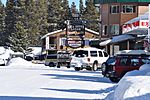
Looking east, January 2010


See also
 In Spanish: Cooke City (Montana) para niños
