Big Horn County, Montana facts for kids
Quick facts for kids
Big Horn County
|
|
|---|---|

|
|

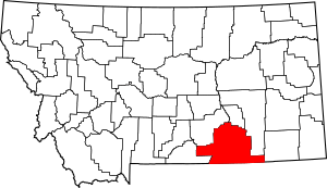
Location within the U.S. state of Montana
|
|
 Montana's location within the U.S. |
|
| Country | |
| State | |
| Founded | January 13, 1913 |
| Named for | Bighorn sheep |
| Seat | Hardin |
| Largest city | Hardin |
| Area | |
| • Total | 5,015 sq mi (12,990 km2) |
| • Land | 4,995 sq mi (12,940 km2) |
| • Water | 19 sq mi (50 km2) 0.4% |
| Population
(2020)
|
|
| • Total | 13,124 |
| • Estimate
(2022)
|
12,851 |
| • Density | 2.6169/sq mi (1.01041/km2) |
| Time zone | UTC−7 (Mountain) |
| • Summer (DST) | UTC−6 (MDT) |
| Congressional district | 2nd |
|
|
Big Horn County is a county in the state of Montana, USA. In 2020, about 13,124 people lived there. The main town and county seat is Hardin.
The county got its name from the bighorn sheep. These animals live in the Rocky Mountains. The river and mountain range are also named after them. Big Horn County was created in 1913. It is located on the southern border of Montana. A large part of the county is within the Crow Indian Reservation. Some areas of the county face economic challenges.
Contents
History of Big Horn County
A very important event happened here on June 25, 1876. This was the Battle of Little Bighorn. It is also known as the Battle of the Greasy Grass. This name is used by the Lakota and other Plains Indian tribes.
Geography of Big Horn County
Big Horn County covers a total area of about 5,015 square miles. Most of this area, about 4,995 square miles, is land. Only a small part, about 19 square miles, is water. This makes it the fifth-largest county in Montana by land area.
Most of the land in the county is part of Indian reservations. The Crow Indian Reservation covers about 64% of the county. The Northern Cheyenne Indian Reservation covers another 6%.
The county is also home to several mountain ranges. These include the Big Horn, Pryor, and Wolf mountains.
Major Roads in Big Horn County
You can travel through Big Horn County on several important roads:
Neighboring Counties
Big Horn County shares its borders with several other counties:
- Carbon - to the west
- Yellowstone - to the northwest
- Treasure - to the north
- Rosebud - to the northeast
- Powder River - to the east
- Sheridan County, Wyoming - to the south
- Big Horn County, Wyoming - to the southwest
Protected Natural Areas
Parts of Big Horn County are protected natural areas:
Climate in Big Horn County
Big Horn County has a semi-arid climate. This means it is generally dry, but not a desert. It gets more rain than a desert, but less than a humid area.
Population of Big Horn County
| Historical population | |||
|---|---|---|---|
| Census | Pop. | %± | |
| 1920 | 7,015 | — | |
| 1930 | 8,543 | 21.8% | |
| 1940 | 10,419 | 22.0% | |
| 1950 | 9,824 | −5.7% | |
| 1960 | 10,007 | 1.9% | |
| 1970 | 10,057 | 0.5% | |
| 1980 | 11,096 | 10.3% | |
| 1990 | 11,337 | 2.2% | |
| 2000 | 12,671 | 11.8% | |
| 2010 | 12,865 | 1.5% | |
| 2020 | 13,124 | 2.0% | |
| 2022 (est.) | 12,851 | −0.1% | |
| U.S. Decennial Census 1790–1960, 1900–1990, 1990–2000, 2010–2020 |
|||
In 2020, the county had 13,124 people. In 2010, there were 12,865 people living here. There were about 4,004 households. The average household had about 3 people. The average age of people in the county was about 30.5 years old.
Economy of Big Horn County
The main industries in Big Horn County are coal mining and farming. Farms and ranches in the area mostly raise beef cattle. They also grow crops like sugar beets, alfalfa, and different types of grains.
Towns and Communities
City
- Hardin (This is the county seat)
Town
Census-designated places
These are areas that are like towns but not officially incorporated:
- Busby
- Crow Agency
- Fort Smith
- Forty Mile Colony
- Muddy
- Pryor
- St. Xavier
- Wyola
Unincorporated communities
These are smaller communities that are not officially recognized as cities or towns:
Former communities
These communities no longer exist:
Images for kids
See also
 In Spanish: Condado de Big Horn (Montana) para niños
 | Stephanie Wilson |
 | Charles Bolden |
 | Ronald McNair |
 | Frederick D. Gregory |


