Rosebud County, Montana facts for kids
Quick facts for kids
Rosebud County
|
|
|---|---|

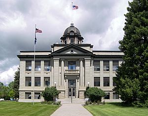
County courthouse in Forsyth
|
|

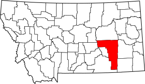
Location within the U.S. state of Montana
|
|
 Montana's location within the U.S. |
|
| Country | |
| State | |
| Founded | February 11, 1901 |
| Named for | Rosebud River |
| Seat | Forsyth |
| Largest city | Colstrip |
| Area | |
| • Total | 5,027 sq mi (13,020 km2) |
| • Land | 5,010 sq mi (13,000 km2) |
| • Water | 17 sq mi (40 km2) 0.3% |
| Population
(2020)
|
|
| • Total | 8,329 |
| • Estimate
(2022)
|
8,088 |
| • Density | 1.65685/sq mi (0.63971/km2) |
| Time zone | UTC−7 (Mountain) |
| • Summer (DST) | UTC−6 (MDT) |
| Congressional district | 2nd |
|
|
Rosebud County is a county located in the state of Montana in the United States. It was created on February 11, 1901. The county is named after the Rosebud River. As of the 2020 census, about 8,329 people lived there. The main town and county seat (where the county government is) is Forsyth.
Contents
Geography of Rosebud County
Rosebud County is a large area. According to the United States Census Bureau, the county covers about 5,027 square miles (13,020 square kilometers). Most of this area, about 5,010 square miles (12,976 square kilometers), is land. Only a small part, about 17 square miles (44 square kilometers), is water.
This makes Rosebud County the fourth largest county in Montana by land area. It is the fifth largest by total area. A part of the Custer National Forest is also found within the county.
Climate in Rosebud County
Most of Rosebud County has a cold semi-arid climate. This means it is generally dry and has cold winters. Summers can be warm to hot.
| Climate data for Brandenberg, Montana, 1991–2020 normals, extremes 1956–present | |||||||||||||
|---|---|---|---|---|---|---|---|---|---|---|---|---|---|
| Month | Jan | Feb | Mar | Apr | May | Jun | Jul | Aug | Sep | Oct | Nov | Dec | Year |
| Record high °F (°C) | 70 (21) |
72 (22) |
86 (30) |
91 (33) |
101 (38) |
111 (44) |
112 (44) |
111 (44) |
105 (41) |
98 (37) |
81 (27) |
70 (21) |
112 (44) |
| Mean maximum °F (°C) | 56.4 (13.6) |
58.6 (14.8) |
72.7 (22.6) |
82.1 (27.8) |
87.9 (31.1) |
96.4 (35.8) |
103.0 (39.4) |
102.1 (38.9) |
97.5 (36.4) |
84.3 (29.1) |
68.9 (20.5) |
56.4 (13.6) |
104.7 (40.4) |
| Mean daily maximum °F (°C) | 35.2 (1.8) |
38.8 (3.8) |
50.2 (10.1) |
60.0 (15.6) |
69.5 (20.8) |
79.3 (26.3) |
89.8 (32.1) |
89.1 (31.7) |
77.2 (25.1) |
61.0 (16.1) |
46.5 (8.1) |
36.0 (2.2) |
61.1 (16.1) |
| Daily mean °F (°C) | 22.9 (−5.1) |
26.3 (−3.2) |
36.4 (2.4) |
45.6 (7.6) |
55.1 (12.8) |
64.4 (18.0) |
72.4 (22.4) |
70.8 (21.6) |
60.3 (15.7) |
46.7 (8.2) |
33.9 (1.1) |
24.2 (−4.3) |
46.6 (8.1) |
| Mean daily minimum °F (°C) | 10.7 (−11.8) |
13.9 (−10.1) |
22.6 (−5.2) |
31.3 (−0.4) |
40.7 (4.8) |
49.4 (9.7) |
55.1 (12.8) |
52.6 (11.4) |
43.5 (6.4) |
32.4 (0.2) |
21.2 (−6.0) |
12.5 (−10.8) |
32.2 (0.1) |
| Mean minimum °F (°C) | −18.0 (−27.8) |
−12.0 (−24.4) |
−1.6 (−18.7) |
14.9 (−9.5) |
25.1 (−3.8) |
37.2 (2.9) |
44.6 (7.0) |
39.8 (4.3) |
29.0 (−1.7) |
14.3 (−9.8) |
−2.4 (−19.1) |
−11.7 (−24.3) |
−26.7 (−32.6) |
| Record low °F (°C) | −42 (−41) |
−40 (−40) |
−41 (−41) |
−2 (−19) |
16 (−9) |
28 (−2) |
34 (1) |
30 (−1) |
19 (−7) |
−12 (−24) |
−32 (−36) |
−44 (−42) |
−44 (−42) |
| Average precipitation inches (mm) | 0.55 (14) |
0.61 (15) |
0.91 (23) |
1.71 (43) |
3.12 (79) |
2.55 (65) |
1.44 (37) |
0.91 (23) |
1.21 (31) |
1.37 (35) |
0.54 (14) |
0.55 (14) |
15.47 (393) |
| Average snowfall inches (cm) | 7.5 (19) |
8.0 (20) |
6.9 (18) |
4.0 (10) |
0.5 (1.3) |
0.0 (0.0) |
0.0 (0.0) |
0.0 (0.0) |
0.0 (0.0) |
1.7 (4.3) |
4.4 (11) |
7.4 (19) |
40.4 (102.6) |
| Average precipitation days (≥ 0.01 in) | 7.3 | 6.9 | 7.4 | 9.0 | 11.0 | 10.0 | 7.1 | 5.4 | 6.1 | 7.1 | 6.1 | 6.3 | 89.7 |
| Average snowy days (≥ 0.1 in) | 6.2 | 5.8 | 3.8 | 1.7 | 0.3 | 0.0 | 0.0 | 0.0 | 0.0 | 1.4 | 3.6 | 5.6 | 28.4 |
| Source 1: NOAA | |||||||||||||
| Source 2: National Weather Service | |||||||||||||
People of Rosebud County
| Historical population | |||
|---|---|---|---|
| Census | Pop. | %± | |
| 1910 | 7,985 | — | |
| 1920 | 8,002 | 0.2% | |
| 1930 | 7,347 | −8.2% | |
| 1940 | 6,477 | −11.8% | |
| 1950 | 6,570 | 1.4% | |
| 1960 | 6,187 | −5.8% | |
| 1970 | 6,032 | −2.5% | |
| 1980 | 9,899 | 64.1% | |
| 1990 | 10,505 | 6.1% | |
| 2000 | 9,383 | −10.7% | |
| 2010 | 9,233 | −1.6% | |
| 2020 | 8,329 | −9.8% | |
| 2022 (est.) | 8,088 | −12.4% | |
| U.S. Decennial Census 2010–2020 |
|||
In 2010, there were 9,233 people living in Rosebud County. There were 3,395 households, which are groups of people living together. About 2,318 of these were families.
Most people in the county were white (61.3%). A large number (34.7%) were American Indian. About 3.4% of the population had Hispanic or Latino backgrounds. Many people had family roots from German, English, or Irish ancestors.
The average age of people in the county was 36.5 years old. The average income for a household was about $44,776 per year. For families, the average income was around $56,282.
Towns and Places
Rosebud County has a few main towns and many smaller communities.
Cities
Census-designated places
These are areas that are like towns but are not officially incorporated as cities.
Unincorporated communities
These are smaller places that do not have their own local government.
Former communities
Famous People from Rosebud County
- Heather Sharfeddin – She is a writer of novels who grew up in Rosebud County.
- Frederic Remington (1861-1909) – He was a famous artist known for his Western art. He lived at times on a ranch near Birney and the Cheyenne Indian Reservation. There he hunted, painted, and sketched.
See also
 In Spanish: Condado de Rosebud para niños
 | Mary Eliza Mahoney |
 | Susie King Taylor |
 | Ida Gray |
 | Eliza Ann Grier |

