
Forsyth, Montana facts for kids
Quick facts for kids
Forsyth, Montana
|
|
|---|---|

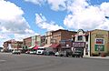
Downtown Forsyth
|
|

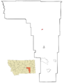
Location of Forsyth, Montana
|
|
| Country | United States |
| State | Montana |
| County | Rosebud |
| Area | |
| • Total | 1.17 sq mi (3.03 km2) |
| • Land | 1.15 sq mi (2.98 km2) |
| • Water | 0.02 sq mi (0.05 km2) |
| Elevation | 2,523 ft (769 m) |
| Population
(2020)
|
|
| • Total | 1,647 |
| • Density | 1,432.17/sq mi (552.89/km2) |
| Time zone | UTC-7 (Mountain (MST)) |
| • Summer (DST) | UTC-6 (MDT) |
| ZIP code |
59327
|
| Area code(s) | 406 |
| FIPS code | 30-27700 |
| GNIS feature ID | 2410523 |
Forsyth is a city in Montana, United States. It is the main town, or county seat, of Rosebud County. In 2020, about 1,647 people lived there.
Forsyth was started in 1876. It was the first settlement along the Yellowstone River. In 1882, the people living there named the town after General James William Forsyth. He was a military leader who commanded a fort nearby. Forsyth has always been an important place for travel. First, steamboats used the river. Later, trains came through on the Northern Pacific Railway. Today, Interstate 94 runs past the city.
Contents
History of Forsyth
Forsyth began in 1876 as a place where steamboats could land on the Yellowstone River. These steamboats helped support the United States Army in the area.
In 1882, a man named Thomas Alexander traded some land to the Northern Pacific Railway. This helped the town grow, and he built four buildings on the main street.
Coxey's Army Incident
In 1894, a group of people called Coxey's Army tried to travel to Washington, D.C. They were protesting about jobs and the economy. A part of this group, led by William Hogan, took over a train in Butte. They were heading east.
After some conflicts along the way, they were stopped in Forsyth on April 25. Soldiers from Fort Keogh arrested 331 of these protesters. This event was unusual because some of the soldiers were Cheyenne Native Americans.
Later History
In the 1980s, the United States Air Force had a special unit in Forsyth. This unit helped test how well B-52 planes could avoid radar during training flights.
Geography and Climate
Forsyth is located on the south side of the Yellowstone River. The city covers about 1.17 square miles (3.03 square kilometers) of land.
Climate in Forsyth
Forsyth has a cold semi-arid climate. This means it is generally dry, but not a desert. It can have cold winters and warm summers.
| Climate data for Forsyth, Montana, 1991–2020 normals, extremes 1975–present | |||||||||||||
|---|---|---|---|---|---|---|---|---|---|---|---|---|---|
| Month | Jan | Feb | Mar | Apr | May | Jun | Jul | Aug | Sep | Oct | Nov | Dec | Year |
| Record high °F (°C) | 70 (21) |
73 (23) |
86 (30) |
91 (33) |
99 (37) |
108 (42) |
110 (43) |
105 (41) |
102 (39) |
93 (34) |
82 (28) |
70 (21) |
110 (43) |
| Mean maximum °F (°C) | 56.9 (13.8) |
59.5 (15.3) |
72.6 (22.6) |
81.9 (27.7) |
88.1 (31.2) |
95.7 (35.4) |
100.7 (38.2) |
99.1 (37.3) |
94.7 (34.8) |
83.2 (28.4) |
68.9 (20.5) |
57.4 (14.1) |
102.0 (38.9) |
| Mean daily maximum °F (°C) | 33.7 (0.9) |
38.0 (3.3) |
49.3 (9.6) |
59.2 (15.1) |
68.8 (20.4) |
78.5 (25.8) |
88.0 (31.1) |
86.5 (30.3) |
75.4 (24.1) |
60.0 (15.6) |
46.1 (7.8) |
35.4 (1.9) |
59.9 (15.5) |
| Daily mean °F (°C) | 21.9 (−5.6) |
25.7 (−3.5) |
36.3 (2.4) |
46.1 (7.8) |
55.8 (13.2) |
65.2 (18.4) |
73.1 (22.8) |
71.1 (21.7) |
60.5 (15.8) |
46.8 (8.2) |
33.9 (1.1) |
24.0 (−4.4) |
46.7 (8.2) |
| Mean daily minimum °F (°C) | 10.2 (−12.1) |
13.5 (−10.3) |
23.3 (−4.8) |
32.9 (0.5) |
42.8 (6.0) |
52.0 (11.1) |
58.2 (14.6) |
55.8 (13.2) |
45.6 (7.6) |
33.7 (0.9) |
21.7 (−5.7) |
12.6 (−10.8) |
33.5 (0.8) |
| Mean minimum °F (°C) | −15.4 (−26.3) |
−9.6 (−23.1) |
1.2 (−17.1) |
18.7 (−7.4) |
28.4 (−2.0) |
40.7 (4.8) |
48.7 (9.3) |
43.4 (6.3) |
31.6 (−0.2) |
16.8 (−8.4) |
−0.5 (−18.1) |
−10.0 (−23.3) |
−23.6 (−30.9) |
| Record low °F (°C) | −38 (−39) |
−38 (−39) |
−31 (−35) |
1 (−17) |
19 (−7) |
34 (1) |
41 (5) |
32 (0) |
19 (−7) |
−11 (−24) |
−27 (−33) |
−44 (−42) |
−44 (−42) |
| Average precipitation inches (mm) | 0.61 (15) |
0.58 (15) |
0.94 (24) |
1.85 (47) |
2.92 (74) |
2.54 (65) |
1.38 (35) |
1.19 (30) |
1.38 (35) |
1.37 (35) |
0.66 (17) |
0.58 (15) |
16.00 (406) |
| Average snowfall inches (cm) | 7.7 (20) |
7.3 (19) |
3.9 (9.9) |
2.8 (7.1) |
0.4 (1.0) |
0.0 (0.0) |
0.0 (0.0) |
0.0 (0.0) |
0.1 (0.25) |
1.5 (3.8) |
4.0 (10) |
6.9 (18) |
34.6 (89.05) |
| Average precipitation days (≥ 0.01 in) | 6.3 | 5.9 | 6.6 | 8.3 | 10.6 | 10.1 | 7.2 | 5.5 | 5.7 | 7.0 | 5.8 | 5.3 | 84.3 |
| Average snowy days (≥ 0.1 in) | 4.9 | 3.3 | 2.7 | 1.0 | 0.2 | 0.0 | 0.0 | 0.0 | 0.1 | 0.8 | 2.5 | 3.7 | 19.2 |
| Source 1: NOAA | |||||||||||||
| Source 2: National Weather Service | |||||||||||||
People of Forsyth
| Historical population | |||
|---|---|---|---|
| Census | Pop. | %± | |
| 1890 | 308 | — | |
| 1910 | 1,398 | — | |
| 1920 | 1,838 | 31.5% | |
| 1930 | 1,591 | −13.4% | |
| 1940 | 1,696 | 6.6% | |
| 1950 | 1,906 | 12.4% | |
| 1960 | 2,032 | 6.6% | |
| 1970 | 1,873 | −7.8% | |
| 1980 | 2,553 | 36.3% | |
| 1990 | 2,178 | −14.7% | |
| 2000 | 1,944 | −10.7% | |
| 2010 | 1,777 | −8.6% | |
| 2020 | 1,647 | −7.3% | |
| U.S. Decennial Census | |||
In 2010, there were 1,777 people living in Forsyth. These people made up 807 households. Most residents (95%) were White. There were also smaller groups of African American, Native American, and Asian people. About 2.4% of the population was Hispanic or Latino.
The average age in Forsyth was 46.4 years old. About 22.2% of the people were under 18. About 20% were 65 years or older. The number of males and females was almost equal.
Education in Forsyth
The Forsyth High School offers many classes. It uses technology to help students get ready for college. The school updates its technology plan often to make sure students have good internet access and lab tools.
The high school sports teams are called the Forsyth Dogies. They play against teams from nearby towns like Baker and Colstrip. Their school colors are purple and white.
The Rosebud County Library serves the people in the Forsyth area.
Local Media
Forsyth has its own local newspaper called the Independent Press.
There are also two radio stations in Forsyth: KIKC-AM and KIKC-FM. People in Forsyth can also listen to radio stations from Miles City.
Transportation
Forsyth is easy to reach by road. It is located along Interstate 94. Also, US Route 12 and US Route 10 pass through the city.
For air travel, there is a public airport called Tillitt Field Airport. It is located about 3 miles east of town.
Famous People from Forsyth
- Samuel Russell Barr: He was a state legislator in Minnesota.
- John Melcher: He used to be a U.S. senator. He worked as a veterinarian in Forsyth and was even the mayor in 1955.
- Carol Thurston: She was an actress.
Images for kids
-
Downtown Forsyth
-
Location of Forsyth, Montana
See also
 In Spanish: Forsyth (Montana) para niños
