
National Register of Historic Places listings in Big Horn County, Montana facts for kids

Have you ever wondered about the cool old buildings and places around you? In Big Horn County, Montana, there are many special spots that are listed on the National Register of Historic Places. This is like a special list kept by the United States government. It helps protect places that are important to history, architecture, or culture. When a place is on this list, it means it's worth saving for future generations to learn from and enjoy.
There are 39 amazing places in Big Horn County on this list. Two of them are even more special and are called National Historic Landmarks. This means they are super important to the history of the entire country!
Contents
Cool Historic Places in Big Horn County
Let's explore some of the fascinating historic places you can find in Big Horn County. Each one tells a unique story about the past.
Important Landmarks and Battlefields
Some places are famous for big events or their unique history.
- Annashisee Iisaxpuatahcheeaashisee-Medicine Wheel on Bighorn River: This ancient site, located north of Fort Smith, is a special medicine wheel. These stone circles were built by Native American tribes for ceremonies and astronomical observations. It's a sacred place that connects us to the spiritual traditions of the past.
- Bighorn Ditch Headgate: West of Fort Smith, this headgate is part of an old irrigation system. It helped bring water from the Bighorn River to farms, which was very important for people living here long ago.
- Chief Plenty Coups (Alek-Chea-Ahoosh) House: Near Pryor, this was the home of Chief Plenty Coups, a famous leader of the Crow Nation. His home is now a state park, where you can learn about his life and the history of the Crow people. It's a National Historic Landmark!
- Fort C.F. Smith Historic District: East of Fort Smith, this area was once a military fort. It played a role in the conflicts and changes that happened in the West during the 1800s.
- Little Bighorn Battlefield National Monument: South of Hardin, this is one of the most famous battlefields in American history. It's where the Battle of the Little Bighorn took place in 1876 between the U.S. Army and Native American tribes like the Lakota, Cheyenne, and Arapaho. It's also a National Historic Landmark.
- Moncure Tipi: Near Busby, this site features a tipi, a traditional home of many Native American tribes. It reminds us of the rich cultural heritage of the area.
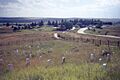
- Rosebud Battlefield-Where the Girl Saved Her Brother: South of Kirby, this battlefield is another important site from the conflicts of the 1870s. It's known for a battle that happened just before the Little Bighorn, and it's also a National Historic Landmark.
- St. Xavier Mission Church and Rectory: Located on the Big Horn River, this historic church and rectory were important centers for the community and for religious life in the Crow Indian Reservation.
Historic Homes and Buildings
Many buildings in Big Horn County are recognized for their architecture or for the important people who lived or worked there.
- Baldwin House: In Lodge Grass, this house is a historic example of homes from the past.
- John Boyum House: Located in Hardin, this house is recognized for its historical value.
- Thomas H. Burke House: Another historic home in Hardin.
- Cammock's Hotel: In Lodge Grass, this old hotel was a place where travelers and locals gathered.
- Camp Four: Northeast of Fort Smith, this site was likely a camp or outpost from earlier times.
- Chivers Memorial Church: In Lodge Grass, this church is a historic place of worship.
- Commercial District (Hardin): This area in Hardin includes many old buildings that were once busy shops and businesses. It shows how the town grew over time.
- J.W. Drew Grain Elevator: In Lodge Grass, this tall building was used to store grain, which was a big part of the local economy.
- William Ebeling House: A historic house in Hardin.
- Charles S. Eder House: Another historic home in Hardin.
- First Baptist Church (Hardin): This church in Hardin has a long history in the community.
- Haverfield Hospital: In Hardin, this was an important hospital that served the area.
- Francis Kopriva House: A historic house in Hardin.
- Lee Homestead: Northeast of Decker, this homestead shows how early settlers lived and worked the land.
- Lodge Grass City Jail: This old jail in Lodge Grass gives us a peek into how law and order were handled in the past.
- Lodge Grass Merchandise Company Store: In Lodge Grass, this store was a central place for people to buy goods.
- OW Ranch: South of Birney, this ranch is a historic district, showing how large ranches operated.
- George Pease's Second Store: Another historic store in Lodge Grass.
- J.J. Ping House: A historic house in Hardin.
- Reno Apartments: These apartments in Hardin are recognized for their historical significance.
- Residential District (Hardin): This area in Hardin has many historic homes, showing the different styles of houses built long ago.
- John Ryan's House: A historic house in Lodge Grass.
- St. Joseph Catholic Church (Hardin): This church in Hardin is another important religious building.
- Jay Sharp's Store: A historic store in Lodge Grass.
- Simmonsen's House: A historic house in Lodge Grass.
- Dominic Stevens House: A historic house in Lodge Grass.
- Sullivan Rooming House: In Hardin, this building provided rooms for people to stay.
- James J. Sullivan House: A historic house in Hardin.
- J.M. Trytten House: A historic house in Lodge Grass.
- J.S. Tupper House: A historic house in Hardin.
- Alvin Young Barn and Cabin Historic District: Near Busby, this district includes old barns and cabins, showing how people lived and farmed in the past.
Images for kids
-
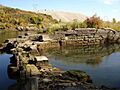
The Bighorn Ditch Headgate, west of Fort Smith.
-
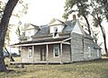
The historic home of Chief Plenty Coups near Pryor.
-
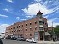
A building in the Commercial District of Hardin.
-
The Little Bighorn Battlefield National Monument.
-
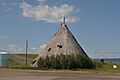
The Moncure Tipi near Busby.
-
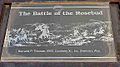
The Rosebud Battlefield State Park.
-
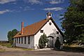
The St. Xavier Mission Church and Rectory.

.jpg)
_001.jpg)


