Yellowstone County, Montana facts for kids
Quick facts for kids
Yellowstone County
|
||
|---|---|---|

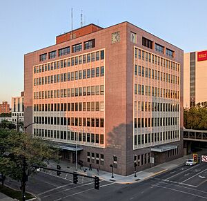
Yellowstone County Courthouse in Billings, 2024
|
||
|
||

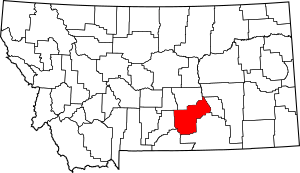
Location within the U.S. state of Montana
|
||
 Montana's location within the U.S. |
||
| Country | ||
| State | ||
| Founded | February 26, 1883 | |
| Named for | Yellowstone River | |
| Seat | Billings | |
| Largest city | Billings | |
| Area | ||
| • Total | 2,649 sq mi (6,860 km2) | |
| • Land | 2,633 sq mi (6,820 km2) | |
| • Water | 16 sq mi (40 km2) 0.6% | |
| Population
(2020)
|
||
| • Total | 164,731 | |
| • Estimate
(2022)
|
169,852 |
|
| • Density | 62.186/sq mi (24.010/km2) | |
| Time zone | UTC−7 (Mountain) | |
| • Summer (DST) | UTC−6 (MDT) | |
| Congressional district | 2nd | |
|
||
Yellowstone County is a very important county in the state of Montana. It has the most people living there! In 2020, over 164,000 people called it home. The main city and county seat is Billings, which is also the biggest city in Montana.
Yellowstone County gets its name from the Yellowstone River. This river flows right through the county, from the southwest to the northeast. The river itself was named after the yellow sandstone cliffs found in this area. Yellowstone County is part of the larger Billings Metropolitan Area.
Contents
Exploring Yellowstone County
Land and Water
Yellowstone County covers a large area. It has about 2,649 square miles in total. Most of this is land, around 2,633 square miles. There are also 16 square miles of water, which is about 0.6% of the total area.
Main Roads
Many important roads help people travel through Yellowstone County. These roads connect different towns and cities. They also link the county to other parts of Montana and nearby states.
 I-90
I-90 I-90 Bus.
 I-94
I-94 US 87
US 87 US 212
 US 310
 MT 3
MT 3 MT 47
MT 47
Public Transportation
Yellowstone County has ways for people to get around without a car.
- Billings Metropolitan Transit helps people travel within Billings.
- Express Arrow and Jefferson Lines offer bus services to other towns and states.
Neighboring Areas
Yellowstone County shares its borders with several other counties in Montana.
- Musselshell County is to the north.
- Rosebud County is to the northeast.
- Treasure County is to the east.
- Big Horn County is to the southeast.
- Carbon County is to the southwest.
- Stillwater County is to the west.
- Golden Valley County is to the northwest.
Special Protected Places
Yellowstone County is home to some special protected areas. These places help preserve nature and history.
- Part of the Nez Perce National Historical Park is here.
- Pompeys Pillar National Monument is also located in the county.
People of Yellowstone County
Yellowstone County has grown a lot over the years. More and more people have chosen to live here.
| Historical population | |||
|---|---|---|---|
| Census | Pop. | %± | |
| 1890 | 2,065 | — | |
| 1900 | 6,212 | 200.8% | |
| 1910 | 22,944 | 269.3% | |
| 1920 | 29,600 | 29.0% | |
| 1930 | 30,785 | 4.0% | |
| 1940 | 41,182 | 33.8% | |
| 1950 | 55,875 | 35.7% | |
| 1960 | 79,016 | 41.4% | |
| 1970 | 87,367 | 10.6% | |
| 1980 | 108,035 | 23.7% | |
| 1990 | 113,419 | 5.0% | |
| 2000 | 129,352 | 14.0% | |
| 2010 | 147,972 | 14.4% | |
| 2020 | 164,731 | 11.3% | |
| 2022 (est.) | 169,852 | 14.8% | |
| U.S. Decennial Census 1790–1960 1900–1990 1990–2000 2010–2020 |
|||
Population in 2020
In 2020, the census counted 164,731 people living in Yellowstone County.
Population in 2010
Back in 2010, there were 147,972 people living here. Most people were white (90.7%). About 4.0% were American Indian. People from other backgrounds also lived here, making the county diverse. About 4.7% of the population was of Hispanic or Latino origin.
Many families lived in the county. About 30.5% of households had children under 18. The average age of people in the county was 38.3 years old.
Towns and Cities
Yellowstone County has several communities where people live.
Cities
Town
- Broadview is a smaller town.
Census-designated places
These are areas that are like towns but are not officially incorporated as cities or towns.
- Acton
- Ballantine
- Custer
- Huntley
- Lockwood
- Mountain View Colony
- Nibbe
- Pompeys Pillar
- Shepherd
- Worden
Other Communities
There are also other smaller communities that are not officially incorporated.
Old Towns (Ghost Towns)
Some places in Yellowstone County used to be towns but are now abandoned. These are called ghost towns.
Education in Yellowstone County
Yellowstone County has many school districts. These districts help make sure kids get a good education.
Schools for All Grades (K-12)
Some districts teach students from kindergarten all the way through 12th grade.
- Custer K-12 Schools
- Huntley Project K-12 Schools
- Lockwood K-12 Schools
High School Districts
These districts focus on high school students.
- Billings High School District
- Broadview High School District
- Laurel High School District
- Shepherd High School District
Elementary School Districts
These districts are for younger students in elementary school.
- Billings Elementary School District
- Blue Creek Elementary School District
- Broadview Elementary School District
- Canyon Creek Elementary School District
- Elder Grove Elementary School District
- Elysian Elementary School District
- Independent Elementary School District
- Laurel Elementary School District
- Molt Elementary School District
- Morin Elementary School District
- Pioneer Elementary School District
- Shepherd Elementary School District
- Yellowstone Academy Elementary School District
See also
In Spanish: Condado de Yellowstone (Montana) para niños
 | Misty Copeland |
 | Raven Wilkinson |
 | Debra Austin |
 | Aesha Ash |


