Ballantine, Montana facts for kids
Quick facts for kids
Ballantine, Montana
|
|
|---|---|

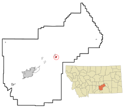
Location of Ballantine, Montana
|
|
| Country | United States |
| State | Montana |
| County | Yellowstone |
| Area | |
| • Total | 0.91 sq mi (2.36 km2) |
| • Land | 0.91 sq mi (2.36 km2) |
| • Water | 0.00 sq mi (0.00 km2) |
| Elevation | 2,995 ft (913 m) |
| Population
(2020)
|
|
| • Total | 293 |
| • Density | 321.98/sq mi (124.32/km2) |
| Time zone | UTC-7 (Mountain (MST)) |
| • Summer (DST) | UTC-6 (MDT) |
| ZIP code |
59006
|
| Area code(s) | 406 |
| FIPS code | 30-03625 |
| GNIS feature ID | 0768484 |
Ballantine is a small community in Yellowstone County, Montana, United States. It's known as a census-designated place (CDP), which means it's a special area identified by the census bureau for statistics, but it's not officially a city or town with its own local government. Ballantine is located about 9 miles (14 km) northeast of Billings along Interstate 94.
In 2020, about 293 people lived here. Ballantine is part of a larger farming area called the Huntley Project. This project is an irrigation district that helps bring water to farms. Many people in Ballantine live on farms and ranches around the main town area.
Contents
History of Ballantine
Ballantine was founded on land that used to be part of the Crow Indian Reservation. In 1896, a railroad company, the Burlington & Missouri River Railroad, set up a station here. They named it Ballantine after an early settler named E. P. Ballantine. By 1907, the community had its own post office.
A big change happened in 1907 when Ballantine became part of the Huntley Project. This was a special government project to bring water to dry land. Thanks to irrigation, the area changed from dry sagebrush to fertile farms. Farmers started growing crops like sugar beets and alfalfa. More people moved to Ballantine, including many immigrants from Europe. Churches were built, and the community grew. The Anita Dam and Reservoir, which helps with irrigation, was finished in 1937. Workers from the Civilian Conservation Corps, a program that helped people find jobs during the Great Depression, built it.
Geography of Ballantine
Ballantine is located in a flat area at 45°56′55″N 108°8′44″W. The entire area of Ballantine is land, covering about 0.9 square miles (2.36 square kilometers). It's easy to reach, as it's close to Interstate 94, about 30 miles east of Billings.
Climate in Ballantine
Ballantine has a semi-arid climate. This means it's generally dry, but it does get some rain. The weather can have big changes. The hottest temperature ever recorded in Ballantine was 110°F (43°C) on July 5, 1936. The coldest temperature ever recorded was a very chilly -50°F (-46°C) on February 15, 1936.
Population and People
| Historical population | |||
|---|---|---|---|
| Census | Pop. | %± | |
| 2020 | 293 | — | |
| U.S. Decennial Census | |||
In 2000, there were 346 people living in Ballantine. The population density was about 379 people per square mile. Most people in Ballantine were White, with smaller numbers of African American, Native American, and Asian residents. About 11.56% of the population identified as Hispanic or Latino.
There were 130 households in Ballantine. Many households (about 61.5%) were married couples living together. About 30% of households had children under 18 years old. The average household had about 2.66 people. The population was spread out in age, with about 25% under 18 years old and about 14% who were 65 or older. The average age was 40 years old.
Education in Ballantine
Students in Ballantine attend schools that are part of the Huntley Project K-12 Schools district. This district serves students from kindergarten all the way through 12th grade.
See also
 In Spanish: Ballantine (Montana) para niños
 | Sharif Bey |
 | Hale Woodruff |
 | Richmond Barthé |
 | Purvis Young |

