Wyola, Montana facts for kids
Quick facts for kids
Wyola, Montana
|
|
|---|---|

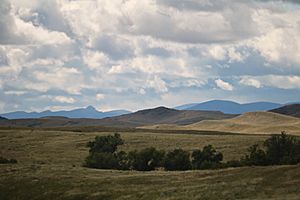
Landforms near Wyola, Montana
|
|

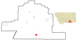
Location of Wyola, Montana
|
|
| Country | United States |
| State | Montana |
| County | Big Horn |
| Area | |
| • Total | 6.73 sq mi (17.42 km2) |
| • Land | 6.73 sq mi (17.42 km2) |
| • Water | 0.00 sq mi (0.00 km2) |
| Elevation | 3,721 ft (1,134 m) |
| Population
(2020)
|
|
| • Total | 190 |
| • Density | 28.25/sq mi (10.91/km2) |
| Time zone | UTC-7 (Mountain (MST)) |
| • Summer (DST) | UTC-6 (MDT) |
| ZIP code |
59089
|
| Area code(s) | 406 |
| FIPS code | 30-82075 |
| GNIS feature ID | 0778710 |
Wyola (which means Alachúa Uhpáko in the Crow language) is a small community in Big Horn County, Montana, United States. It's called a census-designated place (CDP). This means it's a place that looks like a town but isn't officially set up as one.
In 2010, about 215 people lived there. Most of the people in Wyola are Native American. The largest group is the Crow Tribe.
Wyola started as a stop for the Chicago, Burlington & Quincy Railroad trains. The Crow people called this spot Ammoole, which means "Where they wait." This name came from the train station. The community got its own post office in 1911.
Contents
Wyola's Location and Surroundings
Wyola is located at 45.126409 degrees north and -107.393430 degrees west. The main highway, Interstate 90, goes close by. You can get to Wyola from Exit 544.
The Little Bighorn River flows nearby, adding to the area's natural beauty. Wyola is also part of the Crow Indian Reservation. The community covers about 17.4 square kilometers (about 6.7 square miles) of land.
Wyola's Weather
Wyola has a type of weather called a warm-summer humid continental climate. This means it has warm summers and cold, snowy winters.
Here's a look at the weather in Wyola:
| Climate data for Wyola, Montana, 1991–2020 normals, extremes 1922–2006 | |||||||||||||
|---|---|---|---|---|---|---|---|---|---|---|---|---|---|
| Month | Jan | Feb | Mar | Apr | May | Jun | Jul | Aug | Sep | Oct | Nov | Dec | Year |
| Record high °F (°C) | 69 (21) |
74 (23) |
80 (27) |
91 (33) |
96 (36) |
107 (42) |
108 (42) |
108 (42) |
102 (39) |
93 (34) |
79 (26) |
78 (26) |
108 (42) |
| Mean maximum °F (°C) | 57.4 (14.1) |
60.9 (16.1) |
68.9 (20.5) |
79.0 (26.1) |
86.8 (30.4) |
93.7 (34.3) |
99.8 (37.7) |
99.0 (37.2) |
92.9 (33.8) |
84.2 (29.0) |
69.0 (20.6) |
60.3 (15.7) |
101.7 (38.7) |
| Mean daily maximum °F (°C) | 38.1 (3.4) |
40.9 (4.9) |
51.4 (10.8) |
60.5 (15.8) |
70.7 (21.5) |
80.7 (27.1) |
90.0 (32.2) |
87.4 (30.8) |
77.6 (25.3) |
61.0 (16.1) |
47.2 (8.4) |
38.1 (3.4) |
62.0 (16.6) |
| Daily mean °F (°C) | 24.2 (−4.3) |
26.4 (−3.1) |
36.2 (2.3) |
44.9 (7.2) |
54.3 (12.4) |
64.4 (18.0) |
71.1 (21.7) |
68.4 (20.2) |
58.9 (14.9) |
45.0 (7.2) |
33.1 (0.6) |
24.7 (−4.1) |
46.0 (7.8) |
| Mean daily minimum °F (°C) | 10.4 (−12.0) |
11.9 (−11.2) |
20.9 (−6.2) |
29.2 (−1.6) |
37.9 (3.3) |
48.1 (8.9) |
52.2 (11.2) |
49.3 (9.6) |
40.2 (4.6) |
29.1 (−1.6) |
19.1 (−7.2) |
11.2 (−11.6) |
30.0 (−1.1) |
| Mean minimum °F (°C) | −19.1 (−28.4) |
−14.8 (−26.0) |
−5.2 (−20.7) |
14.1 (−9.9) |
24.9 (−3.9) |
33.4 (0.8) |
40.0 (4.4) |
38.0 (3.3) |
25.8 (−3.4) |
14.4 (−9.8) |
−3.0 (−19.4) |
−14.4 (−25.8) |
−26.2 (−32.3) |
| Record low °F (°C) | −42 (−41) |
−43 (−42) |
−29 (−34) |
−4 (−20) |
15 (−9) |
26 (−3) |
28 (−2) |
27 (−3) |
15 (−9) |
−19 (−28) |
−37 (−38) |
−46 (−43) |
−46 (−43) |
| Average precipitation inches (mm) | 0.39 (9.9) |
0.41 (10) |
0.73 (19) |
2.08 (53) |
3.85 (98) |
2.09 (53) |
1.67 (42) |
0.67 (17) |
1.41 (36) |
1.83 (46) |
0.81 (21) |
0.54 (14) |
16.48 (418.9) |
| Average snowfall inches (cm) | 10.4 (26) |
9.3 (24) |
10.5 (27) |
6.8 (17) |
0.9 (2.3) |
0.1 (0.25) |
0.0 (0.0) |
0.0 (0.0) |
1.2 (3.0) |
2.5 (6.4) |
7.5 (19) |
9.8 (25) |
59.0 (150) |
| Average precipitation days (≥ 0.01 in) | 4.5 | 4.2 | 5.9 | 10.0 | 10.3 | 11.2 | 8.0 | 5.6 | 7.5 | 7.6 | 4.7 | 4.2 | 83.7 |
| Average snowy days (≥ 0.1 in) | 5.0 | 4.9 | 4.5 | 2.2 | 0.3 | 0.0 | 0.0 | 0.0 | 0.4 | 1.2 | 3.3 | 5.3 | 27.1 |
| Source 1: NOAA | |||||||||||||
| Source 2: National Weather Service(WRCC mean maxima, mean minima, average snowfall, NWS snowy days 1922-2006) | |||||||||||||
Who Lives in Wyola?
| Historical population | |||
|---|---|---|---|
| Census | Pop. | %± | |
| 2020 | 190 | — | |
| U.S. Decennial Census | |||
In 2000, there were 186 people living in Wyola. They lived in 52 households, and 43 of these were families. Most of the people living there were Native American, making up about 79% of the population. About 19% were White.
Many households had children under 18 living with them. The average household had about 3 to 4 people. The community's population was quite young, with many people under 18 years old. The average age was 25 years.
Learning in Wyola
The Wyola School District helps students learn from kindergarten all the way through 8th grade.
Famous People from Wyola
- Bill Yellowtail is a notable person from Wyola. He was a candidate for the Montana seat in the United States House of Representatives.
See also
 In Spanish: Wyola (Montana) para niños
 | John T. Biggers |
 | Thomas Blackshear |
 | Mark Bradford |
 | Beverly Buchanan |

