
Lewis and Clark Expedition facts for kids

The Lewis and Clark Expedition was a famous journey across the western part of North America. It was led by two explorers, Meriwether Lewis and William Clark. They were chosen by U.S. President Thomas Jefferson to explore the huge area called the Louisiana Purchase. The United States had just bought this land from France. This land is now a big part of the Central and Western United States.
Lewis and Clark left Saint Louis in 1804 with a group of 33 people. They traveled all the way to the Pacific Ocean by 1806. Along the way, they saw many new things and wrote down everything. A Shoshone Native American woman named Sacagawea joined them and helped guide them. After their amazing journey, Lewis became Governor of Louisiana Territory, and Clark became Governor of Missouri Territory.
Contents
Key Dates of the Expedition
Getting Ready for the Journey

President Thomas Jefferson had always been interested in the western parts of the continent. He wanted to know more about these unknown lands. He read books by other explorers, like Captain James Cook and Le Page du Pratz. These books made him want to send his own expedition.
Jefferson also learned that Britain wanted to control the fur trade in the Columbia River area. This made him realize how important it was to claim the western lands for the United States quickly.
In 1803, President Jefferson asked Congress to pay for an expedition. He wanted them to explore the Louisiana Purchase and reach the Pacific Ocean.
Jefferson chose U.S. Army Captain Meriwether Lewis to lead this important trip. Lewis then picked William Clark to be his second-in-command. Lewis was very skilled at living in the wilderness. Jefferson helped him prepare for the long journey ahead.
Lewis and Clark met near Louisville in October 1803. They gathered a small group of skilled young men, called the "Nine Young Men." These men were the first members of the "Corps of Discovery."
Their main goals were to explore the new lands from the Louisiana Purchase. They also wanted to make friends and trade with the Native American tribes along the Missouri River. Jefferson also hoped to claim the Pacific Northwest and Oregon territory for the U.S. by showing an American presence there.
The U.S. government made special silver medals for the expedition. These were called Indian Peace Medals. They had Jefferson's picture and a message of friendship. The explorers gave these medals to the tribes they met. These medals showed that the U.S. now claimed the land. The expedition also brought powerful weapons, like a special air rifle, to show their military strength.
They packed lots of supplies, including gunpowder, lead for their guns, knives, and tools for blacksmithing. They also brought maps, flags, gifts, and medicines. They spent a lot of time making sure they had everything they needed.
The plan was to travel up the Missouri River to where it starts. Then, they would go to the Pacific by following the Columbia River.
The Long Journey West

The expedition started on May 14, 1804. There were 33 people in the group. They had trained during the winter at Camp Dubois in Indiana Territory. They met Lewis in St. Charles, Missouri, and then followed the Missouri River west. Soon, they passed the last Euro-American town on the river, called La Charrette.
The group traveled through what is now Kansas City, Missouri, and Omaha, Nebraska. On August 20, 1804, Sergeant Charles Floyd sadly died. He was the only member of the expedition to die. He was buried on a bluff by the river, which is now called Floyd's Bluff. This place is in Sioux City, Iowa. They marked his grave with a cedar post.
By the end of August, Lewis and Clark reached the edge of the Great Plains. This area was full of animals like elk, deer, bison, and beavers.
The Lewis and Clark Expedition met about two dozen different Native American nations. These tribes were very important. Without their help, the expedition might have starved or gotten lost in the Rocky Mountains.
The Americans had some problems when they met the Lakota nation. The Lakota are also called Sioux. There was a concern that the two sides might fight. One of their horses disappeared, and they thought the Sioux took it. The Sioux asked the explorers to stay or give more gifts to pass through their land. They almost fought several times, but both sides eventually calmed down. The expedition then continued into Arikara territory.
In the winter of 1804–05, the group built Fort Mandan near what is now Washburn, North Dakota. Here, they met a French-Canadian fur trapper named Toussaint Charbonneau and his young Shoshone wife, Sacagawea. Charbonneau became a translator for the expedition. Peace was made with the Mandan chiefs by sharing a peace pipe.
They followed the Missouri River to where it began. Then, they crossed the Continental Divide at Lemhi Pass. They used canoes to travel down the mountains on the Clearwater River, the Snake River, and the Columbia River. They passed places like Celilo Falls and what is now Portland, Oregon. Lewis used old notes and maps to help them navigate by a volcano.

The expedition faced another harsh winter. On November 24, 1805, they voted to camp on the south side of the Columbia River, near modern Astoria, Oregon. They built Fort Clatsop there. By March 22, the stormy weather stopped, and they started their journey home the next morning. They used canoes and then traveled by land.
On July 3, before crossing the Continental Divide again, the group split into two teams. Lewis wanted to explore the Marias River. Lewis's group of four met some men from the Blackfeet nation. During the night, the Blackfeet tried to steal their weapons. In the struggle, the soldiers killed two Blackfeet men. Lewis and his companions quickly fled over 100 miles (160 km) before stopping.
Meanwhile, Clark had entered the Crow tribe's land. Half of Clark's horses disappeared during the night, but they didn't see any Crow people. Lewis and Clark stayed separated until they reached the Yellowstone and Missouri Rivers on August 11. Before they reunited, one of Clark's hunters accidentally shot Lewis in the leg, thinking he was an elk. Once they were back together, the Corps quickly returned home by the Missouri River. They arrived in St. Louis on September 23, 1806.
The expedition successfully reached the Pacific Ocean. They mapped the area and showed America's presence there, which helped claim the land. They also made diplomatic and trade connections with many Native American nations. However, they did not find the Northwest Passage, which was a water route across the continent.
In March 1804, the Spanish in New Mexico learned about the American expedition. They sent four groups of soldiers and others from Santa Fe to stop Lewis and Clark. But the expedition was moving so fast, traveling 70 to 80 miles a day, that the Spanish could not catch them.
Discoveries in Geography and Science

The Lewis and Clark Expedition greatly improved understanding of the Northwest's geography. They created the first accurate maps of the area. During their trip, Lewis and Clark drew about 140 maps. Their work "filled in the main outlines" of the region.
The expedition recorded many natural resources and plants that were new to Euro-Americans. However, the Native American peoples already knew about them. Lewis and Clark were the first Americans to cross the continental divide. They were also the first Americans to see Yellowstone and enter Montana. They wrote official descriptions of these different regions. Their visit to the Pacific Northwest, along with their maps and claims of ownership (using medals and flags), helped the U.S. claim the land under the Doctrine of Discovery.
The American Philosophical Society (APS) strongly supported the expedition. Their main duties, given by Jefferson, were scientific. They studied geography, astronomy, ethnology (the study of cultures), climatology (climate), mineralogy (minerals), meteorology (weather), botany (plants), ornithology (birds), and zoology (animals).
The expedition recorded over 200 plants and animals that were new to science. They also noted at least 72 different native tribes.
Jefferson wanted the expedition to declare U.S. "sovereignty" (control) and show their military strength. This was to make sure native tribes would be under U.S. rule, similar to how European colonizers acted elsewhere. After the expedition, the maps they made helped with further exploration and settlement of this huge territory in the years that followed.
In 1807, Patrick Gass, a soldier on the trip, published his story of the journey. He was promoted to Sergeant during the expedition. A two-volume history of the expedition was published in 1814. It was edited by Paul Allen, but the real author was a banker named Nicholas Biddle. The full reports of the Lewis and Clark journals were not made public until much later. The earliest official copy of their journals is at the Maureen and Mike Mansfield Library at the University of Montana.
Sacagawea's Important Role

Sacagawea (born around 1788, died December 20, 1812) was a Shoshone woman. She traveled with her husband, Toussaint Charbonneau, on the expedition to the Pacific Ocean. Her son, Jean Baptiste Charbonneau, was born in 1805 with help from the expedition members.
While many stories have been told about Sacagawea, some of them are exaggerated or not true. Scholars say she did notice some land features. However, "Sacagawea...was not the guide for the Expedition." She was very important to them as a translator. She also helped in other ways. Seeing a woman with her baby made some Native American nations feel more at ease. She played a key role in talking to chiefs, easing tensions, and making the mission seem peaceful.
In his writings, Meriwether Lewis sometimes wrote negatively about her. But Clark thought highly of her. He even helped support her children in later years. In their journals, Lewis and Clark used some terms like "squar" and "savages" to describe Sacagawea and other Native Americans.
Honoring Lewis and Clark
Since their expedition, Lewis and Clark have been remembered and honored in many ways. They have appeared on coins, money, and postage stamps.
- In the 1970s, Camp Dubois, their winter assembly camp, was recognized as the starting point of their journey. In 2019, Pittsburgh, Pennsylvania, was also recognized as a starting point.
- They have been featured on coins, currency, and commemorative postage stamps.
- A special type of American elm tree, Ulmus americana 'Lewis & Clark', was released in 2004 to celebrate the expedition's 200th anniversary. This tree is resistant to Dutch elm disease.
- Lewis and Clark County in Montana and the Lewis and Clark River in Oregon are named after them.
- The Lewis and Clark Public School District in North Dakota also carries their names.
- North Dakota Highway 1804 and North Dakota Highway 1806 are named after the years of their travels through the area. These highways are part of the Lewis and Clark National Historic Trail.
- Campsite Lewis and Clark at Camp Sandy Beach in Yawgoog Scout Reservation in Rockville, Rhode Island, also honors the explorers.
Interesting Facts about the Lewis and Clark expedition
- Lewis and Clark made contact with over 70 different Native American tribes, learning about their languages, customs, and ways of life.
- They created about 140 detailed maps, which were the first accurate maps of the vast western territory.
- Lewis and Clark were the first Americans to cross the Continental Divide and the first to officially describe places like Yellowstone and much of Montana.
- The expedition documented over 200 new species of plants and animals that were previously unknown to European Americans.
- The Spanish government, who also claimed some of the western lands, tried to stop the explorers by sending armed expeditions from Santa Fe, New Mexico, to intercept and capture them. But Lewis and Clark were too fast and too clever, and the Spanish never caught them.
- Sergeant Charles Floyd was the only member of the expedition to die during the entire trip. He most likely died from appendicitis. Floyd was buried on a bluff overlooking the river, which is now named Floyd's Bluff in Sioux City, Iowa.
Images for kids
-
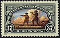
Lewis and Clark Expedition, 2004
This U.S. postage stamp celebrated the 200th anniversary of the Expedition. -
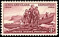
Lewis and Clark Expedition
This stamp was issued for the 150th anniversary in 1954. -
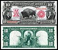
Lewis & Clark were honored (along with the American bison) on the Series of 1901 $10 Legal Tender.
-
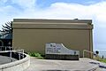
The Lewis and Clark Interpretive Center in Cape Disappointment State Park.
-
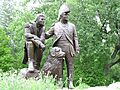
A statue of Lewis and Clark (with their dog, Seaman (dog)) in St. Charles, Missouri.
-
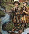
A Lewis & Clark Mosaic image in Missouri.
-
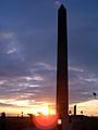
The Sergeant Floyd Monument in Sioux City, Iowa. It is the first of 2,600 National Historic Landmarks in the United States.
-
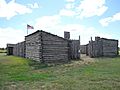
A reconstruction of Camp Dubois (Camp Wood). The Corps of Discovery stayed here during the winter of 1803–1804. They waited for the Louisiana Purchase to be officially transferred to the United States.
-
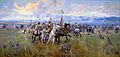
Lewis and Clark Meeting the Salish in Ross Hole, September 4, 1805.
-
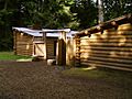
A reconstruction of Fort Clatsop on the Columbia River near the Pacific Ocean.


.jpg)


See also
 In Spanish: Expedición de Lewis y Clark para niños
