
Clearwater River (Idaho) facts for kids
Quick facts for kids Clearwater River |
|
|---|---|

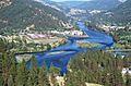
Clearwater River near Greer Ferry
|
|

Map showing the Clearwater River watershed
|
|
| Native name | Kooskooskia |
| Country | United States |
| State | Idaho |
| Region | Idaho County, Clearwater County, Shoshone County, Nez Perce County |
| Cities | Orofino, Lewiston |
| Physical characteristics | |
| Main source | Middle Fork Clearwater River Confluence of Selway River and Lochsa River, Idaho County 1,453 ft (443 m) 46°08′28″N 115°35′53″W / 46.14111°N 115.59806°W |
| 2nd source | South Fork Clearwater River Near Red River Hot Springs, Idaho County 4,285 ft (1,306 m) 45°52′09″N 115°18′32″W / 45.86917°N 115.30889°W |
| River mouth | Snake River Lewiston, Nez Perce County 741 ft (226 m) 46°25′30″N 117°02′14″W / 46.42500°N 117.03722°W |
| Length | 74.8 mi (120.4 km), Southeast-northwest |
| Basin features | |
| River system | Snake River |
| Basin size | 9,645 sq mi (24,980 km2) |
| Tributaries | |
The Clearwater River is a major river in the Northwestern United States. It flows through Idaho, a state known for its beautiful nature. The river is about 74.8 mi (120.4 km) long. It starts in the Bitterroot Mountains and flows west. Finally, it joins the Snake River near the city of Lewiston.
In October 1805, the famous explorers Lewis and Clark traveled down the Clearwater River. They used dugout canoes, starting near Orofino. About six weeks later, they reached the Pacific Ocean.
The Clearwater River is the largest river that flows into the Snake River. It got its name from the Nez Perce people. They called it Koos-Koos-Kai-Kai, which means "clear water." The area of land that drains into the Clearwater River is huge, covering 9,645 square miles (24,980 km2).
Contents
The River's Journey: Where the Clearwater River Flows
The Clearwater River begins in a special way. Near the small town of Kooskia, two main parts come together. These are the Middle Fork and the South Fork of the Clearwater River.
The Middle Fork is larger. It's formed by the Lochsa and Selway rivers. These rivers flow from the Bitterroot Mountains to the east. The South Fork is smaller and starts in the Selway-Bitterroot Wilderness to the south.
After these forks meet, the Clearwater River flows northwest. It passes by the Heart of the Monster site. This is an important place for the Nez Perce National Historical Park. U.S. Route 12 follows the river. It goes through towns like Kamiah.
The river continues through a deep canyon. It passes Greer and then reaches Orofino. Here, the river turns west. A bit further, the North Fork joins it near Ahsahka. This is also close to the Dworshak Reservoir.
As the river flows, its canyon gets deeper. It cuts into the Columbia Plateau. The Clearwater passes through small communities like Lenore and Myrtle. It also meets the Potlatch River from the north.
Near Spalding, U.S. Route 95 crosses the river. The river then gets wider and slower. This is because it's approaching Lower Granite Lake. Finally, as it crosses into Washington, the Clearwater River joins the mighty Snake River.
Branches of the Clearwater River: Its Many Forks
The Clearwater River system has several important branches, often called "forks." These forks are like different arms of the river.
- Clearwater River: This is the main part of the river. It flows from west of Orofino to Lewiston, where it meets the Snake River.
- Potlatch River: This river flows through Latah, Clearwater, and Nez Perce Counties before joining the main Clearwater.
- North Fork Clearwater River: This branch starts near Illinois Peak. It flows through Clearwater County and joins the main river west of Orofino.
- Little North Fork Clearwater River: This smaller stream flows through Shoshone and Clearwater Counties. It joins the North Fork in the Dworshak Reservoir.
- Middle Fork Clearwater River: This fork is in Idaho County. It's formed where the Selway and Lochsa rivers meet at Lowell.
- South Fork Clearwater River: Also in Idaho County, this fork starts near Red River Hot Springs. It flows to Kooskia, where it joins the Middle Fork.
- Little Clearwater River: This small stream is in Idaho County. It flows from near Three Prong Mountain to near Spot Mountain.
River Changes: The Dworshak Dam
The biggest change to the Clearwater River system is the Dworshak Dam. It was finished in the early 1970s. This dam created the Dworshak Reservoir, which is the only large lake on the Clearwater system.
The Dworshak Dam is on the North Fork of the Clearwater River. It's located northwest of Orofino. This dam is very tall. It blocks salmon and steelhead fish from swimming upstream. There is no special "fish ladder" to help them pass the dam.
History: The Idaho-Washington Border
The border between Washington and Idaho was set using the Clearwater River. It was defined as the line running north from where the Clearwater River meets the Snake River. This border is very close to the 117th meridian west longitude.
Images for kids
-
Clearwater River near Orofino, ID

See also
 In Spanish: Río Clearwater (Idaho) para niños
