Columbia Plateau facts for kids
The Columbia Plateau is a large natural area in the United States. It stretches across parts of Washington, Oregon, and Idaho. This wide, flat area is a type of plateau made from ancient lava flows. It sits between the Cascade Range and the Rocky Mountains. The mighty Columbia River flows right through it.
Contents
How the Columbia Plateau Formed
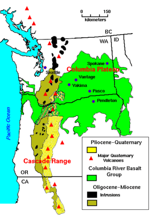
About 10 to 15 million years ago, during the late Miocene and early Pliocene periods, something amazing happened. Huge amounts of molten rock, called lava, poured out onto the surface. This type of eruption is called a flood basalt. It covered a massive area of about 63,000 square miles (163,000 km²) in the Pacific Northwest.
Lava Flows and Sinking Land
Over millions of years, lava flow after lava flow built up. The lava eventually became more than 6,000 feet (1.8 km) thick! As this molten rock came out, the Earth's outer layer, called the Earth's crust, slowly sank. It sank into the empty space left by the rising lava. This sinking created a large, slightly sunken lava plateau.
The Columbia River's Path
The ancient Columbia River was forced to change its path. The moving lava pushed it into the course we see today. As the lava flowed, it filled up old river valleys. This created natural dams, which then formed lakes. Scientists have found many interesting things in the beds of these old lakes. These include fossil leaves, petrified wood, fossil insects, and even bones of ancient animals.
The Hot Spot Underneath
Scientists believe a special heat source is melting rock deep beneath the Columbia Plateau. This heat source is far from where Earth's tectonic plates usually meet. To understand why so much lava erupted here, scientists studied the age of the lava flows. They found that the youngest rocks are near Yellowstone National Park. The farther west they looked, the older the lava was.
What is a Hot Spot?
A likely explanation for this is a "hot spot". This is an extremely hot plume of material rising from deep inside the Earth's mantle. Geologists think that a temperature change happens deep down, where the Earth's core meets the mantle. This change creates a huge plume, hundreds of kilometers wide. This plume rises straight to the Earth's surface.
Yellowstone's Connection
The path of this hot spot begins in the west and goes all the way to Yellowstone National Park. The steaming vents and explosive geysers at Yellowstone show there's a lot of heat underground. The hot spot itself stays in one place. But the North American Plate (the large piece of Earth's crust we live on) is slowly moving over it. This movement creates a clear record of how fast and in what direction the plate is moving.
Plants and Nature
Part of the Columbia Plateau is known as the Columbia Plateau ecoregion. This area is part of a larger group of natural regions. These include "Nearctic temperate and subtropical grasslands, savannas, and shrublands." This means the area has many types of grasses, open woodlands, and shrubs.
Cities in the Columbia Plateau
Many cities are located within the Columbia Plateau.
Washington Cities
- Davenport
- Reardan
- Kennewick
- Moses Lake
- Pasco
- Pullman
- Richland
- Spokane
- Walla Walla
- Yakima
- Goldendale
- Deer Park
Oregon Cities
See also
 In Spanish: Meseta del Columbia para niños
 | Roy Wilkins |
 | John Lewis |
 | Linda Carol Brown |


