
Lochsa River facts for kids
Quick facts for kids Lochsa River |
|
|---|---|

Headwaters near Powell in 2008
|
|

Lochsa and Selway rivers
|
|


Location of the mouth of the Lochsa River in Idaho
|
|
| Country | United States of America |
| State | Idaho |
| County | Idaho |
| Physical characteristics | |
| Main source | Confluence of Crooked Fork and Colt Killed Creek, Bitterroot Mountains Near Powell Ranger Station, Idaho County, Idaho 3,441 ft (1,049 m) 46°30′30″N 114°40′54″W / 46.50833°N 114.68167°W |
| River mouth | Clearwater River Lowell, Idaho County, Idaho 1,453 ft (443 m) 46°08′25″N 115°35′58″W / 46.14028°N 115.59944°W |
| Length | 70.1 mi (112.8 km) |
| Basin features | |
| Basin size | 1,180 sq mi (3,100 km2) |
| Type: | Recreational |
| Designated: | October 2, 1968 |
| Reference #: | P.L. 90-542 |
The Lochsa River is a beautiful river located in the mountains of north central Idaho, in the northwestern United States. It's one of the main rivers that flow into the Clearwater River. The name Lochsa comes from the Nez Perce language and means rough water, which is a perfect description for its fast-moving sections! Another name for the river, used by the Salish people, is Ep Smɫí, which means "It Has Salmon."
The Lochsa River (pronounced "lock-saw") is special because the U.S. Congress made it part of the National Wild and Scenic Rivers System in 1968. This means it's protected and kept wild. There are no dams on the Lochsa or its nearby rivers, so the water flows freely and naturally. In late spring, usually from mid-May to mid-June, the Lochsa River is known as one of the best places in the world for exciting whitewater adventures.
The main part of the Lochsa River is about 70 miles (110 km) long. It starts near the Powell Ranger Station in the Bitterroot Mountains and flows to Lowell. At Lowell, the Lochsa joins the Selway River to form the Middle Fork of the Clearwater River. As it flows, the river drops almost 2,000 feet (610 m) in elevation, making it very steep and fast.
The area that drains into the Lochsa River covers about 1,180 square miles (3,060 km²) in Idaho County. The river gets its water from the large amounts of snow that melt in the Bitterroot Mountains, which receive a lot of snow each year.
Contents
Where the Lochsa River Flows
The Lochsa River begins where two smaller streams, Crooked Fork and Colt Killed Creek, meet near the Powell Ranger Station in northeastern Idaho. From there, it flows about 70 miles (113 km) southwest to the town of Lowell.
The river runs right next to U.S. Route 12 for its entire length. It winds through the Clearwater National Forest in the Bitterroot Mountains. Just past Lowell, the Lochsa and the Selway River come together to create the Middle Fork of the Clearwater River.
Journey from Source to Mouth
Near its start, the Lochsa receives a small stream called Walton Creek. This creek flows through a special area where adult salmon are counted before joining the river. A bit further downstream, the Lochsa passes White Sand Campground and then the Powell Ranger Station. It also flows by Lochsa Lodge and Powell Campground. Along this stretch, smaller creeks like Cliff Creek and Jay Creek add their water to the Lochsa.
As the river continues, it receives many other creeks. Some of these include Imnamatnoon (Papoose) Creek, Robin Creek, and Wendover Creek. It also passes by Whitehouse Campground and Wendover Campground. Further along, Cold Storage Creek, Eagle Creek, and Badger Creek join the river.
Between 60 and 50 miles (97 and 80 km) from its end, the Lochsa gets water from Doe Creek, Burnt Creek, and Warm Springs Creek. It flows past Jerry Johnson Campground and receives Colgate Creek and Mink Creek. You can also find Colgate Warm Springs and the Colgate Licks nearby. More creeks like Bear Mountain Creek, Post Office Creek, and Lake Creek also join the river here.
From about 48 to 40 miles (77 to 64 km) from its mouth, the Lochsa passes Weir Creek Hot Springs. It receives Weir Creek, Ginger Creek, Mocus Creek, Ashpile Creek, Indian Meadows Creek, and Indian Grave Creek. The river also flows by the White Pine Access Area and receives Eagle Mountain Creek.
Over the next 10 miles (16 km), the river is joined by Skookum Creek, Stanley Creek, and Castle Creek. It passes Green Flat Campground and Nine Mile Rest Area. Bald Mountain Creek, Dutch Creek, and Hard Creek also flow into the Lochsa.
Closer to its end, the Lochsa receives Pass Creek, No-See-Um Creek, Dipper Creek, and Sherman Creek. Lone Knob Creek joins from the left. The river passes Wilderness Gateway Campground and Boulder Flat, and Boulder Creek adds its water. The Lochsa Work Center is also along this stretch. Many more creeks, such as Sardine Creek, Fish Creek, Bee Creek, Eel Creek, and Otter Slide Creek, join the river. It also passes Beaver Flat and receives Big Stew Creek and Snowshoe Creek.

In its final 10 miles (16 km), the Lochsa flows past Glade Creek Campground and receives Glade Creek. It also passes Apgar Campground and receives Apgar Creek. Chance Creek, Canyon Creek, Hellgate Creek, Handy Creek, Rye Patch Creek, Cat Creek, and Kerr Creek all contribute to the river. Pete King Creek joins from the right. The river passes Icicle Spring and receives Lowell Creek. Finally, it flows past the town of Lowell and under the Lowell Bridge before meeting the Selway River.
After the Lochsa and Selway rivers meet, they form the Middle Fork of the Clearwater River. This river then flows west and eventually joins the Snake River at Lewiston. The Snake River then flows into the Columbia River.
History of the Lochsa River
Long ago, before European Americans arrived, the Nez Perce people used a trail along the Lochsa River. They traveled to the plains of Montana to hunt buffalo. Other tribes, like the Kootenai and Salish, used the river trail to find salmon in the rivers that flow into the Columbia basin.
In September 1805, the famous explorers Lewis and Clark traveled along the Lolo Trail. They went into and out of the Lochsa Gorge. They described the area near the modern-day Powell ranger station as very difficult to travel through, with many fallen trees and steep, rocky paths. They even had to kill a colt (a young horse) for food because they were so hungry. They named a stream "Colt Killed Creek" after this event.
Lewis and Clark faced heavy snow and almost starved before they finally reached the Weippe Prairie. This is where they first met the Nez Perce tribe, who helped them.
The United States Forest Service sometimes allows companies to cut timber in the Lochsa watershed. There have been discussions about trading land with a timber company, which has caused some debate. People are concerned about how this might affect the water quality and wildlife in the area.
U.S. Route 12 Along the River
Route 12 is a highway that follows the Lochsa River along its north bank. This highway was one of the last two-lane U.S. highways to be built, finished in the early 1960s. It connects Lewiston, Idaho, with Missoula, Montana, by going over Lolo Pass.
Years ago, two railroad companies, the Northern Pacific and Union Pacific, planned to build tracks along the Lochsa. The Northern Pacific even started building in 1908 but stopped the project in 1909. It took another 50 years for the highway to be completed along the river.
In recent years, some companies wanted to transport very large loads, as wide as both lanes of Route 12 and as tall as three stories, from Lewiston to places like Canada. However, after several groups filed lawsuits to stop these shipments, the companies decided not to use the highway for such big loads.
Wildlife in the Lochsa Area
The Lochsa River watershed is home to many amazing animals. You can often see deer and elk on the hillsides. Black bears and moose can be found in meadows and wet areas.
Many birds live along the river, including Canada geese, swans, eagles, osprey, and great blue herons. Wild turkeys are seen at lower elevations. Sometimes, you might spot more rare animals like mountain lions, snow geese, mountain goats, and harlequin ducks.
The river is also full of fish! Some of the fish living in the Lochsa River include cutthroat trout, rainbow trout, chinook salmon, and steelhead.
Fun Activities on the Lochsa River
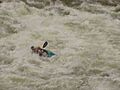
The Lochsa River is a popular spot for Kayaking and whitewater rafting. People usually enjoy these activities between April and June. A guide for floating the Lochsa River lists over 60 rapids between Powell and Lowell. Most of these rapids are rated as Class III-IV, which means they are medium to difficult.
Sometimes, depending on how much water is flowing, the difficulty of some rapids can increase to Class VI. This is the highest level and means they are extremely challenging, sometimes even impossible to navigate safely. For example, the Class VI rapids at Castle Creek are described as very long and twisting, with large holes and waves. They are considered too dangerous to run when the water is high.
You can join commercial trips with experienced guides, or if you have enough skills, you can run the rapids on your own. There are several places along Highway 12 where you can access the river, with parking lots at Knife Edge, Split Creek, Fish Creek, Nine Mile, and White Pine.
Besides rafting and kayaking, there are many other fun things to do in the Lochsa area. These include backcountry skiing, bicycling on parts of the TransAmerica Trail, fly fishing (where you might have daily limits or catch-and-release rules), hiking, swimming, camping, and picnicking. It's a great place to explore the outdoors!
Images for kids
-
Kayaker in Lochsa River

