Lewiston, Idaho facts for kids
Quick facts for kids
Lewiston
|
|
|---|---|
|
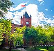
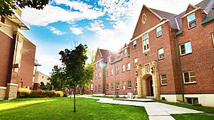
Reid Hall Clock Tower at Lewis–Clark State College
Nez Perce County Courthouse
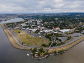
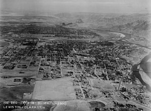
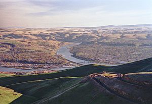
Aerial of Lewiston and the Port of Lewiston
|
|
| Nicknames:
L-Town, River City |
|
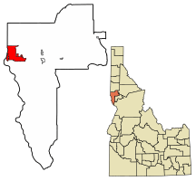
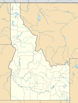
Location of Lewiston in Nez Perce County, Idaho
|
|
| Country | United States |
| State | Idaho |
| County | Nez Perce |
| Founded | 1861 |
| Incorporated | 1861 |
| Named for | Meriwether Lewis |
| Government | |
| • Type | Strong-Mayor |
| Area | |
| • City | 18.11 sq mi (46.89 km2) |
| • Land | 17.30 sq mi (44.81 km2) |
| • Water | 0.81 sq mi (2.08 km2) |
| Elevation | 745 ft (227 m) |
| Population
(2020)
|
|
| • City | 34,203 |
| • Density | 1,895.15/sq mi (731.71/km2) |
| • Metro | 61,476 (US: 365th) |
| Time zone | UTC−8 (PST) |
| • Summer (DST) | UTC−7 (PDT) |
| ZIP code |
83501
|
| Area code(s) | 208, 986 (208 |
| FIPS code | 16-46540 |
| GNIS feature ID | 0396788 |
Lewiston is a city in Idaho, United States. It is the main city of Nez Perce County. Lewiston is the third-largest city in northern Idaho. It is also the twelfth-largest city in the whole state.
Lewiston is part of the Lewiston-Clarkston Metropolitan Statistical Area. This area includes Nez Perce County in Idaho and Asotin County in Washington. In 2020, about 34,203 people lived in Lewiston.
The city sits where the Snake River and Clearwater River meet. Dams and locks on these rivers allow some ocean ships to reach Lewiston. This makes the Port of Lewiston Idaho's only seaport. It is also the farthest inland port connected to the Pacific Ocean. The Lewiston-Nez Perce County Airport serves the city by air.
Lewiston was started in 1861 because of a gold rush. This gold rush began near Pierce the year before. In March 1863, Lewiston became the first capital of the new Idaho Territory. But it was capital for only a short time. The capital moved to Boise in December 1864.
Today, Lewiston's main industries are farming, paper, and wood products. It also has light manufacturing. Ammunition making is very important here. Companies like CCI and Speer Bullet have their main offices in Lewiston. The city is a key center for shopping, healthcare, and fun in the area. It is also a gateway to the Hells Canyon National Recreation Area.
Lewiston is home to Lewis–Clark State College, a public college. Fun events in Lewiston include the Dogwood Festival, Hot August Nights, and the Lewiston Roundup.
History of Lewiston
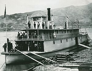
Early Inhabitants and Explorers
The Nez Perce (also called Nimiipuu) have lived in the Lewiston area for thousands of years. They were the first people here.
The first Europeans to visit were part of the David Thompson trip in 1803. Thompson wanted to set up fur trading posts. The famous Lewis and Clark Expedition came here in October 1805. They met Nez Perce settlements at the future city site. They returned to the valley in spring 1806 on their way back from the Pacific Ocean.
Founding and Capital City Status
The town was likely named after Meriwether Lewis from the Lewis and Clark Expedition. It was founded in 1861. This happened after a gold rush started nearby in Pierce. The first newspaper in Idaho, The Golden Age, began in Lewiston in 1862. The Lewiston Morning Tribune started in 1892.
In March 1863, Lewiston became the first capital of the new Idaho Territory. But this did not last long. As the gold rush in northern Idaho slowed, a new one began near Idaho City. This city became the largest in the Northwest. So, in December 1864, the capital was moved from Lewiston to Boise. This move was very unpopular in northern Idaho. The governor and secretary secretly took the official items and left Lewiston.
Growth and Education
To make people in North Idaho happier, the University of Idaho was given to nearby Moscow in 1889. It started teaching in 1892. Lewis–Clark State College, then called Lewiston State Normal School, was set up in 1893. These were Idaho's first three colleges. Lewiston also had Idaho's first public school in 1862.
Geography and Landscape
Rivers and Dams
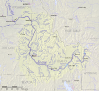
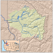
Lewiston is located where the Snake River and Clearwater River meet. Just west of Lewiston is Clarkston, Washington, its smaller twin city. The Snake River flows north and forms the border with Washington. The Clearwater River flows west and forms the city's northern border. Where they meet, the Snake River turns west into Washington. It then flows into the Columbia River.
About 30 miles northwest of Lewiston is the Lower Granite Dam. This is the last of four dams on the lower Snake River. It was finished in 1975. This dam created Lower Granite Lake, which reaches all the way to Lewiston.
City Area and Elevation
The U.S. Census Bureau says Lewiston covers about 18 square miles. Most of this is land, with a small part being water. Downtown Lewiston is about 740 to 780 feet above sea level. This is only a little higher than the river itself. Before the Lower Granite Dam, the river was about 30 feet lower.
Away from downtown, the land quickly gets higher. For example, U.S. 95 north of Lewiston climbs to 2,756 feet. The lowest point in Idaho is on the Snake River in Lewiston. This is where it meets the Clearwater River.
The Orchards Area
The southern part of the city is mostly homes and is called "The Orchards." This area is much higher than downtown, about 1,400 feet high. It is named for the fruit orchards that used to be there. This area became part of the city in late 1969. This almost doubled the city's population and size. Today, you won't see many orchards. But many homes in this area have fruit trees in their backyards. The Lewiston-Nez Perce County Airport is also in The Orchards area.
Climate and Weather
Lewiston has a semi-arid climate. This means it has dry summers and sometimes cold, but short, winters. The weather is often influenced by mild air from the Pacific Ocean. Temperatures can reach 100°F on about 7 days a year. They reach 90°F on about 42 days. It rarely stays below freezing all day.
Lewiston gets about 12.31 inches of rain each year. It also gets about 10.5 inches of snow. The growing season for plants is long, about 195 days. Freezing temperatures usually happen between October 23 and April 10. Temperatures below 0°F are very rare. The hottest temperature ever was 117°F in July 1939. The coldest was -23°F in December 1919. Tornadoes are very rare here.
| Climate data for Lewiston–Nez Perce County Airport, Idaho (1991−2020 normals, extremes 1881−present) | |||||||||||||
|---|---|---|---|---|---|---|---|---|---|---|---|---|---|
| Month | Jan | Feb | Mar | Apr | May | Jun | Jul | Aug | Sep | Oct | Nov | Dec | Year |
| Record high °F (°C) | 66 (19) |
72 (22) |
80 (27) |
98 (37) |
104 (40) |
115 (46) |
117 (47) |
115 (46) |
108 (42) |
94 (34) |
77 (25) |
67 (19) |
117 (47) |
| Mean maximum °F (°C) | 56.1 (13.4) |
59.4 (15.2) |
69.1 (20.6) |
79.1 (26.2) |
88.9 (31.6) |
96.2 (35.7) |
103.8 (39.9) |
103.5 (39.7) |
95.2 (35.1) |
80.0 (26.7) |
63.0 (17.2) |
55.5 (13.1) |
105.3 (40.7) |
| Mean daily maximum °F (°C) | 42.1 (5.6) |
47.0 (8.3) |
55.1 (12.8) |
62.3 (16.8) |
72.0 (22.2) |
79.0 (26.1) |
90.8 (32.7) |
90.1 (32.3) |
79.5 (26.4) |
63.0 (17.2) |
48.7 (9.3) |
40.8 (4.9) |
64.2 (17.9) |
| Daily mean °F (°C) | 36.2 (2.3) |
39.3 (4.1) |
45.4 (7.4) |
51.5 (10.8) |
60.0 (15.6) |
66.5 (19.2) |
75.8 (24.3) |
75.2 (24.0) |
65.9 (18.8) |
52.5 (11.4) |
41.6 (5.3) |
35.2 (1.8) |
53.8 (12.1) |
| Mean daily minimum °F (°C) | 30.3 (−0.9) |
31.7 (−0.2) |
35.7 (2.1) |
40.7 (4.8) |
48.1 (8.9) |
54.0 (12.2) |
60.9 (16.1) |
60.3 (15.7) |
52.3 (11.3) |
42.0 (5.6) |
34.5 (1.4) |
29.5 (−1.4) |
43.3 (6.3) |
| Mean minimum °F (°C) | 14.8 (−9.6) |
18.2 (−7.7) |
24.6 (−4.1) |
30.9 (−0.6) |
36.2 (2.3) |
44.1 (6.7) |
50.7 (10.4) |
49.9 (9.9) |
40.4 (4.7) |
28.2 (−2.1) |
20.8 (−6.2) |
14.5 (−9.7) |
7.5 (−13.6) |
| Record low °F (°C) | −22 (−30) |
−18 (−28) |
2 (−17) |
20 (−7) |
23 (−5) |
34 (1) |
41 (5) |
41 (5) |
27 (−3) |
15 (−9) |
−3 (−19) |
−23 (−31) |
−23 (−31) |
| Average precipitation inches (mm) | 1.13 (29) |
1.04 (26) |
1.30 (33) |
1.44 (37) |
1.69 (43) |
1.25 (32) |
0.47 (12) |
0.51 (13) |
0.60 (15) |
1.08 (27) |
1.23 (31) |
1.13 (29) |
12.87 (327) |
| Average snowfall inches (cm) | 2.7 (6.9) |
3.8 (9.7) |
0.8 (2.0) |
0.0 (0.0) |
0.0 (0.0) |
0.0 (0.0) |
0.0 (0.0) |
0.0 (0.0) |
0.0 (0.0) |
0.0 (0.0) |
1.3 (3.3) |
4.1 (10) |
12.7 (32) |
| Average precipitation days (≥ 0.01 in) | 11.2 | 9.6 | 11.7 | 11.3 | 10.6 | 8.9 | 3.9 | 3.4 | 4.7 | 8.7 | 11.1 | 11.1 | 106.2 |
| Average snowy days (≥ 0.1 in) | 2.3 | 3.1 | 1.0 | 0.0 | 0.0 | 0.0 | 0.0 | 0.0 | 0.0 | 0.0 | 1.0 | 3.6 | 11.0 |
| Average dew point °F (°C) | 25.3 (−3.7) |
27.0 (−2.8) |
32.9 (0.5) |
33.3 (0.7) |
41.0 (5.0) |
46.6 (8.1) |
46.6 (8.1) |
43.7 (6.5) |
41.0 (5.0) |
39.2 (4.0) |
32.5 (0.3) |
29.3 (−1.5) |
36.5 (2.5) |
| Source 1: NOAA (dew point 1961–1990) | |||||||||||||
| Source 2: National Weather Service | |||||||||||||
Population and People
How Many People Live Here?
As of the 2020 census, Lewiston had 34,203 people. There were 13,895 households. The city had about 1,974 people per square mile.
Most people in Lewiston are White (93.6%). There are also small groups of Native American (0.9%) and Asian (1.0%) people. About 5.0% of the population is Hispanic or Latino.
About 21.4% of the people were under 18 years old. And 19.4% were over 65. The city has slightly more females (51.4%) than males (48.6%).
The average household income in the city was $60,581. About 15.2% of the people lived below the poverty line.
| Historical population | |||
|---|---|---|---|
| Census | Pop. | %± | |
| 1880 | 739 | — | |
| 1890 | 849 | 14.9% | |
| 1900 | 2,425 | 185.6% | |
| 1910 | 6,043 | 149.2% | |
| 1920 | 6,574 | 8.8% | |
| 1930 | 9,403 | 43.0% | |
| 1940 | 10,548 | 12.2% | |
| 1950 | 12,985 | 23.1% | |
| 1960 | 12,691 | −2.3% | |
| 1970 | 26,068 | 105.4% | |
| 1980 | 27,986 | 7.4% | |
| 1990 | 28,082 | 0.3% | |
| 2000 | 30,904 | 10.0% | |
| 2010 | 31,894 | 3.2% | |
| 2020 | 34,203 | 7.2% | |
| U.S. Decennial Census Orchards annexed in late 1969. |
|||
Population in 2010
In 2010, Lewiston had 31,894 people. There were 13,324 households. About 27.8% of households had children under 18. Most households (47.0%) were married couples.
The average age in the city was 39.9 years. About 21.5% of people were under 18. And 18.2% were 65 or older.
Economy and Jobs
Main Industries
Lewiston's economy has always been strong in farming and manufacturing. Its location where the Snake River and Clearwater River meet made it a good place for trade. The Port of Lewiston is Idaho's only seaport. It allows barges to carry grain, fuel, paper, and wood products. These goods travel up and down the Columbia River to the Pacific Ocean. About ten percent of all U.S. wheat exports go through this port. The first barge carrying wheat left Lewiston for Portland on August 9, 1975.
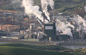
Lewiston's main jobs are in farming, paper, and wood products. The Clearwater Paper Corporation runs a large pulp and paper mill. This mill started in 1950. Making ammunition is also a big and growing business in Lewiston. Companies like CCI and Speer Bullet are based here. Schweitzer Engineering Laboratories also has a factory in Lewiston.
Regional Center
Lewiston is the main center for the Lewis-Clark Valley. It provides transportation, shopping, healthcare, and entertainment. It also offers professional services. With Lewis–Clark State College here, it is also a place for education and job training.
Lewiston's economy is becoming more diverse. This helps keep the economy stable. The city is also a popular place for visitors going to the Hells Canyon National Recreation Area.
Arts and Culture
Festivals and Events
In spring, Lewiston hosts the Dogwood Festival. This event celebrates the many beautiful dogwood trees that bloom then. Their pink blossoms look like snow. The festival also has a "Show and Shine" classic car show.
In late summer, "Hot August Nights" takes place. This festival includes concerts by popular musicians from the 1950s to 1980s. There is also a car show and a night parade on Main Street. In the fall, cottonwood trees release fluffy seeds. These seeds blow through the air like snow.
Lewiston has a big Christmas festival. It includes many lighted displays downtown. At Locomotive Park, large trees and paths are decorated with lights. This happens from Thanksgiving to New Year's. These events are sponsored by the Chamber of Commerce. They are very impressive and attract many visitors.
During Christmas and Easter, the Lewiston Jaycees put up two large lighted displays. These are on Lewiston Hill, visible from almost anywhere in the valley. The Christmas display is a star. The Easter display is a cross. The same lights are used for both.
Sports and Entertainment
Every year, Lewis–Clark State College hosts the Avista NAIA World Series for college baseball in May. The Lewiston Round Up rodeo happens in September. The Lewiston Round Up is a very important rodeo. It is one of the top 50 rodeos in the PRCA.
Lewiston also had a popular professional baseball team. The Lewis-Clark Broncs played from 1952 to 1974. Many players who later became famous played for the Broncs. One famous player was Reggie Jackson. He played for Lewiston in 1966. The team stopped playing in Lewiston in 1975.
Education in Lewiston
Lewiston is home to Lewis–Clark State College. It also has the Lewiston School District. This district runs public schools. These include Lewiston High School, Jenifer Middle School, and Sacajawea Middle School. There are seven elementary schools: Whitman, Webster, Centennial, Orchards, Camelot, McGhee, and McSorley.
The Northwest Children's Home has a treatment center in Lewiston. The Lewiston School District is Independent School District #1.
Lewis-Clark State College's sports teams are called the Warriors. They play in the National Association of Intercollegiate Athletics (NAIA). LCSC's Harris Field ballpark hosts the NAIA World Series. The Warriors have won 19 national titles in baseball. Many of these wins were under coach Ed Cheff.
Media and News
Lewiston's newspaper is the Lewiston Morning Tribune. It was founded in 1892. The local TV station is KLEW-TV. It is a CBS affiliate and started broadcasting on December 7, 1955.
Transportation and Infrastructure
Roads and Highways
Major roads in Lewiston include:
- U.S. 12
- U.S. 95
- SH 128
Airport Services
The Lewiston - Nez Perce County Airport (LWS) offers nonstop flights. You can fly to Denver (DEN) with United Express. You can also fly to Salt Lake City (SLC) and Seattle-Tacoma (SEA) with Delta Connection. These airlines use regional jet planes for their flights.
Waterways and Port
Because of the system of locks and dams on the Columbia River, Lewiston can be reached by some ocean-going ships. It is the end point of Marine Highway M-84. This connects to the M-5 along the coast at Astoria, Oregon.
Lewiston is about 465 miles upstream from the Pacific Ocean. This makes the Port of Lewiston the most inland seaport east of the West Coast. It is also Idaho's only seaport.
Along much of the Snake River, there are levees. These protect against flooding. Most are kept up by the U.S. Army Corps of Engineers.
Notable People from Lewiston
- Austin Arnett, MMA fighter
- Bryan Fuller, screenwriter, television producer
- Julie Gibson, actress
- Sean Paul Lockhart, actor, film producer
- Michael P. Mitchell, member of the Idaho Legislature
- Jack O'Connor, author and hunting editor
- Jason Schmidt, Major League Baseball pitcher
- Jake Scott, guard with Philadelphia Eagles
- Grace Vollmer, painter
Images for kids
See also
 In Spanish: Lewiston (Idaho) para niños
 | Jackie Robinson |
 | Jack Johnson |
 | Althea Gibson |
 | Arthur Ashe |
 | Muhammad Ali |


