Clarkston, Washington facts for kids
Quick facts for kids
Clarkston, Washington
|
|
|---|---|

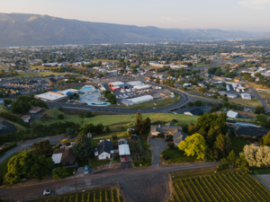
View of Clarkston from the southwest
|
|

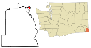
Location of Clarkston, Washington
|
|
| Country | United States |
| State | Washington |
| County | Asotin |
| Named for | William Clark |
| Government | |
| • Type | Mayor–council |
| Area | |
| • Total | 2.23 sq mi (5.78 km2) |
| • Land | 2.06 sq mi (5.32 km2) |
| • Water | 0.17 sq mi (0.45 km2) |
| Elevation | 807 ft (246 m) |
| Population
(2020)
|
|
| • Total | 7,161 |
| • Density | 3,211/sq mi (1,238.9/km2) |
| Time zone | UTC-8 (Pacific (PST)) |
| • Summer (DST) | UTC-7 (PDT) |
| ZIP code |
99403
|
| Area code | 509 |
| FIPS code | 53-12630 |
| GNIS feature ID | 1512093 |
| Website | www.clarkston-wa.com |
Clarkston is a city in Asotin County, Washington, USA. It is part of the Lewiston, ID-WA metropolitan area. The city is located west of Lewiston, Idaho, right across the Snake River.
In 2020, about 7,161 people lived in Clarkston. Students can also go to Walla Walla Community College, which has a campus in Clarkston. Fun fact: Clarkston's ZIP code, 99403, is the highest number for a ZIP code in the main part of the United States!
Contents
History of Clarkston
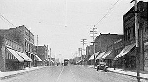
Clarkston was first settled in 1862 by Robert Bracken. It officially became a town on August 14, 1902. Before that, people called the area different names like Jawbone Flats or Concord.
Clarkston is named after William Clark, a famous explorer. He was part of the Lewis and Clark Expedition. Right across the Snake River is Lewiston, which is named after Meriwether Lewis, the other leader of the expedition. The Lewis and Clark Expedition traveled through this area in 1805. They came back in 1806. Interestingly, neither Lewis nor Clark actually visited the side of the river where Clarkston is now.
Geography and Climate
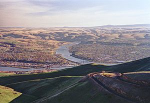
Clarkston is in the Lewis-Clark Valley. It is where the Snake River and Clearwater River meet. The city of Lewiston, Idaho is just across the Snake River from Clarkston.
The city covers about 2.09 square miles (5.41 square kilometers). Most of this area is land, with a small part being water.
Clarkston's Weather
This area has hot and dry summers. Average monthly temperatures are often in the upper 80s to mid-90s Fahrenheit. Some days can even reach 105 degrees Fahrenheit (40.5 degrees Celsius). The highest temperature ever recorded was 118 degrees Fahrenheit (47.8 degrees Celsius) in August 2018. An unofficial record of 122.9 degrees Fahrenheit (50.5 degrees Celsius) was set in June 2021.
Clarkston has a "warm-summer Mediterranean climate." This means it has hot, dry summers and mild, wet winters.
Population Information
| Historical population | |||
|---|---|---|---|
| Census | Pop. | %± | |
| 1910 | 1,257 | — | |
| 1920 | 1,859 | 47.9% | |
| 1930 | 2,870 | 54.4% | |
| 1940 | 3,116 | 8.6% | |
| 1950 | 5,617 | 80.3% | |
| 1960 | 6,209 | 10.5% | |
| 1970 | 6,312 | 1.7% | |
| 1980 | 6,903 | 9.4% | |
| 1990 | 6,753 | −2.2% | |
| 2000 | 7,337 | 8.6% | |
| 2010 | 7,229 | −1.5% | |
| 2020 | 7,161 | −0.9% | |
| U.S. Decennial Census | |||
2010 Census Details
In 2010, there were 7,229 people living in Clarkston. There were 3,226 households in the city. About 1,744 of these were families.
The city's population density was about 3,596.5 people per square mile. Most residents were White (92.1%). Other groups included Native American (2.1%) and Asian (0.7%). About 4.0% of the population was Hispanic or Latino.
About 28.4% of households had children under 18. The average household had 2.20 people. The average family had 2.88 people. The median age in Clarkston was 37.7 years.
Economy and Port

The Port of Clarkston
The Port of Clarkston is very important for trade. It has one of the largest cranes on a river east of Portland. Farming is a big business here. The port helps move a lot of grain using barges.
A company called Clearwater Paper Corporation also uses barges. They transport wood chips and sawdust to a factory in Lewiston. Because Clarkston is inland on the Snake River, the port handles goods. These goods travel to places like Portland and Vancouver. They also go to distributors further inland.
The port also has a marina for personal boats and yachts. Many people travel through the nearby Hells Canyon by boat.
Education in Clarkston
Clarkston has several public elementary schools. These include Parkway, Grantham, Heights, and Highland Elementary Schools. They serve students from kindergarten through sixth grade.
There is also one middle school, Lincoln Middle School. It teaches students in seventh and eighth grades.
Clarkston has one high school for grades 9-12. It is called Charles Francis Adams High School. The high school has about 800 to 850 students. It also has over 100 staff members. The school has a library, a football field, a performing arts stage, and tennis courts.
In addition to public schools, Clarkston is home to Holy Family Catholic School. This school serves students from kindergarten through eighth grade.
Notable People
- Joel Dahmen, a professional golfer
See also
 In Spanish: Clarkston (Washington) para niños
 | Isaac Myers |
 | D. Hamilton Jackson |
 | A. Philip Randolph |


