
List of dams in the Columbia River watershed facts for kids
The Columbia River watershed in the United States and Canada is home to over 60 dams. These huge structures are built across rivers. While some dams help store water or prevent floods, most dams in the Columbia River area are built to make hydroelectricity. This is a clean way to create power using the force of flowing water. These dams produce a lot of electricity, enough to power many homes and cities.
Building these major dams started in the early 1900s. Construction really sped up after the Columbia River Treaty in the 1960s. By the mid-1980s, most of the big dams were finished. There are 14 dams on the main Columbia River, 20 on the Snake River, seven on the Kootenay River, seven on the Pend Oreille River/Clark Fork River, two on the Flathead River, eight on the Yakima River, and two on the Owyhee River. On average, there's a major dam every 72 miles (116 km) in the Columbia watershed! Together, these rivers generate over 36,000 megawatts of power. The biggest power producer is Grand Coulee Dam, which makes 6,809 megawatts. That's more than one-sixth of all the power from dams in this entire river system!
These dams provide lots of power for people in the Pacific Northwest. The lakes created by the dams also offer fun activities like fishing, boating, and windsurfing. Plus, the dams and their locks help keep the river deep and flowing smoothly. This allows Lewiston, Idaho, to be a seaport far inland on the west coast of the United States. However, dams also have environmental effects. For example, they can make it harder for salmon to travel up and down the river to lay their eggs.
The lists below show the dams. They start with the dams on the main Columbia River. Then, they list dams on its smaller rivers (called tributaries), ordered by how long those rivers are.
Contents
Main stem Columbia River dams
These dams are listed from the river's start (Columbia Lake, British Columbia) to its end (Pacific Ocean, Oregon/Washington).
| Name | Height | Capacity (MW) | Province/State(s) | Coordinates | Year of completion | Owner | Reservoir formed | Image |
|---|---|---|---|---|---|---|---|---|
| Mica Dam | 240 m (790 ft) | 2,805 | 52°04′39″N 118°33′59″W / 52.07750°N 118.56639°W | 1973 | BC Hydro | Kinbasket Lake |  |
|
| Revelstoke Dam | 175 m (574 ft) | 2,480 | 51°02′57″N 118°11′36″W / 51.04917°N 118.19333°W | 1984 | BC Hydro | Revelstoke Lake |  |
|
| Keenleyside Dam | 52 m (171 ft) | 185 | 49°20′18″N 117°46′18″W / 49.33833°N 117.77167°W | 1968 | BC Hydro | Raised Arrow Lakes | .jpg) |
|
| Grand Coulee Dam | 550 ft (170 m) | 6,809 | 47°57′26″N 118°58′39″W / 47.95722°N 118.97750°W | 1941 / 1974 | USBR | Franklin D. Roosevelt Lake |  |
|
| Chief Joseph Dam | 236 ft (72 m) | 2,620 | 47°59′42″N 119°38′19″W / 47.99500°N 119.63861°W | 1955 | USACE | Rufus Woods Lake |  |
|
| Wells Dam | 160 ft (49 m) | 840 | 47°56′50″N 119°51′51″W / 47.94722°N 119.86417°W | 1967 | Douglas PUD | Lake Pateros |  |
|
| Rocky Reach Dam | 130 ft (40 m) | 1,287 | 47°31′59″N 120°17′41″W / 47.53306°N 120.29472°W | 1961 | Chelan PUD | Lake Entiat |  |
|
| Rock Island Dam | 135 ft (41 m) | 660 | 47°20′33″N 120°05′40″W / 47.34250°N 120.09444°W | 1933 | Chelan PUD | Rock Island Pool |  |
|
| Wanapum Dam | 185 ft (56 m) | 1,092 | 46°52′40″N 119°58′13″W / 46.87778°N 119.97028°W | 1963 | Grant PUD | Lake Wanapum | .jpg) |
|
| Priest Rapids Dam | 178 ft (54 m) | 955.6 | 46°38′39″N 119°54′36″W / 46.64417°N 119.91000°W | 1961 | Grant PUD | Priest Rapids Lake |  |
|
| McNary Dam | 183 ft (56 m) | 1,133 | 45°56′07″N 119°17′53″W / 45.93528°N 119.29806°W | 1954 | USACE | Lake Wallula |  |
|
| John Day Dam | 184 ft (56 m) | 2,485 | 45°42′57″N 120°41′37″W / 45.71583°N 120.69361°W | 1971 | USACE | Lake Umatilla |  |
|
| The Dalles Dam | 260 ft (79 m) | 2,038 | 45°36′50″N 121°08′02″W / 45.61389°N 121.13389°W | 1957 | USACE | Lake Celilo |  |
|
| Bonneville Dam | 197 ft (60 m) | 1,190 | 45°38′42″N 121°56′27″W / 45.64500°N 121.94083°W | 1937 / 1981 | USACE | Lake Bonneville |  |
Snake River dams
These dams are listed from the river's start (Two Oceans Plateau, Wyoming) to its end (Columbia River, Washington).
| Name | Height | Capacity (MW) | Province/State(s) | Coordinates | Year of completion | Owner | Reservoir formed | Image |
|---|---|---|---|---|---|---|---|---|
| Jackson Lake Dam | 65.5 ft (20.0 m) | 0 | 43°51′30″N 110°35′24″W / 43.85833°N 110.59000°W | 1911 / 1916 / 1989 | USBR | Jackson Lake | ||
| Palisades Dam | 270 ft (82 m) | 176.6 | 43°19′59″N 111°12′12″W / 43.33306°N 111.20333°W | 1957 | USBR | Palisades Reservoir |  |
|
| American Falls Dam | 104 ft (32 m) | 112.4 | 42°46′43″N 112°52′35″W / 42.77861°N 112.87639°W | 1927 / 1978 | USBR | American Falls Reservoir |  |
|
| Minidoka Dam | 86 ft (26 m) | 28.5 | 42°40′10″N 113°29′03″W / 42.66944°N 113.48417°W | 1909-1942 | USBR | Lake Walcott |  |
|
| Milner Dam | 38 ft (12 m) | 59.5 | 42°31′30″N 114°00′35″W / 42.52500°N 114.00972°W | 1905 | Milner Dam, Inc. | Milner Lake |  |
|
| Twin Falls Dam | 25 ft (7.6 m) | 52.9 | 42°35′21″N 114°21′20″W / 42.58917°N 114.35556°W | 1935 / 1995 | Idaho Power Company | Twin Falls Reservoir |  |
|
| Shoshone Falls Dam | 16 ft (4.9 m) | 64 | 42°35′47″N 114°24′04″W / 42.59639°N 114.40111°W | 1907 | Idaho Power Company | Shoshone Falls Reservoir |  |
|
| Swan Falls Dam | 107 ft (33 m) | 25 | 43°14′35″N 116°22′46″W / 43.24306°N 116.37944°W | 1901 | Idaho Power Company | Swan Falls Reservoir |  |
|
| Brownlee Dam | 420 ft (130 m) | 585 | 44°50′13″N 116°54′03″W / 44.83694°N 116.90083°W | 1959 / 1980 | Idaho Power Company | Brownlee Reservoir |  |
|
| Oxbow Dam | 175 ft (53 m) | 220 | 44°58′15″N 116°50′07″W / 44.97083°N 116.83528°W | 1961 | Idaho Power Company | Oxbow Reservoir |  |
|
| Hells Canyon Dam | 330 ft (100 m) | 450 | 45°14′34″N 116°42′05″W / 45.24278°N 116.70139°W | 1967 | Idaho Power Company | Hells Canyon Reservoir |  |
|
| Lower Granite Dam | 181 ft (55 m) | 932 | 46°39′40″N 117°25′41″W / 46.66111°N 117.42806°W | 1975 / 1987 | USACE | Lower Granite Lake |  |
|
| Little Goose Dam | 253 ft (77 m) | 932 | 46°35′13″N 118°01′40″W / 46.58694°N 118.02778°W | 1970 | USACE | Lake Bryan |  |
|
| Lower Monumental Dam | 152 ft (46 m) | 930 | 46°33′48″N 118°32′20″W / 46.56333°N 118.53889°W | 1969 | USACE | Lake Herbert G. West |  |
|
| Ice Harbor Dam | 213 ft (65 m) | 693 | 46°14′58″N 118°52′47″W / 46.24944°N 118.87972°W | 1961 / 1976 | USACE | Lake Sacajawea |  |
Owyhee River dams
These dams are listed from the river's start (near Double Mountain, Nevada) to its end (Snake River, Oregon/Idaho).
| Name | Height | Capacity (MW) | Province/State(s) | Coordinates | Year of completion | Owner | Reservoir formed | Image |
|---|---|---|---|---|---|---|---|---|
| Wild Horse Dam | 114 ft (35 m) | 0 | 41°41′14″N 115°50′43″W / 41.68722°N 115.84528°W | 1937 / 1969 | BIA | Wild Horse Reservoir |  |
|
| Owyhee Dam | 417 ft (127 m) | 5,8,2 | 43°38′31″N 117°14′33″W / 43.64194°N 117.24250°W | 1932 | USBR | Lake Owyhee | 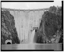 |
Boise River dams
These dams are listed from the river's start (where the North and Middle Forks of the Boise River meet, Idaho) to its end (Snake River, Idaho/Oregon).
| Name | Height | Capacity (MW) | Province/State(s) | Coordinates | Year of completion | Owner | Reservoir formed | Image |
|---|---|---|---|---|---|---|---|---|
| Arrowrock Dam | 350 ft (110 m) | 15 | 43°36′0″N 115°55′12″W / 43.60000°N 115.92000°W | 1915 | United States Bureau of Reclamation | Arrowrock Reservoir |  |
|
| Lucky Peak Dam | 340 ft (100 m) | 101.25 | 43°31′12″N 116°03′0″W / 43.52000°N 116.05000°W | 1955 | United States Army Corps of Engineers | Lucky Peak Lake |  |
|
| Boise River Diversion Dam | 68 ft (21 m) | 3.3 | 43°31′48″N 116°05′24″W / 43.53000°N 116.09000°W | 1908 | United States Bureau of Reclamation | Boise River Diversion Dam Pool |  |
|
| Barber Dam | 25 ft (7.6 m) | 4.14 | 43°34′12″N 116°07′12″W / 43.57000°N 116.12000°W | 1904 | Ada County and Fulcrum Inc. | Barber Dam Pool |  |
South Fork Boise River dams
These dams are listed from the river's start (where Ross Fork and Johnson Creek meet, Idaho) to its end (Boise River, Idaho).
| Name | Height | Capacity (MW) | Province/State(s) | Coordinates | Year of completion | Owner | Reservoir formed | Image |
|---|---|---|---|---|---|---|---|---|
| Anderson Ranch Dam | 456 ft (139 m) | 40 | 43°21′36″N 115°26′24″W / 43.36000°N 115.44000°W | 1947 | United States Bureau of Reclamation | Anderson Ranch Reservoir |  |
Payette River dams
These dams are listed from the river's start (where the South and Middle Forks of the Payette River meet, Idaho) to its end (Snake River, Idaho/Oregon).
| Name | Height | Capacity (MW) | Province/State(s) | Coordinates | Year of completion | Owner | Reservoir formed | Image |
|---|---|---|---|---|---|---|---|---|
| Black Canyon Diversion Dam | 183 ft (56 m) | 10.2 | 43°52′48″N 116°28′48″W / 43.88000°N 116.48000°W | 1924 | United States Bureau of Reclamation | Black Canyon Reservoir | .jpg) |
North Fork Payette River dams
These dams are listed from the river's start (Squaw Meadows, Idaho) to its end (Payette River, Idaho).
| Name | Height | Capacity (MW) | Province/State(s) | Coordinates | Year of completion | Owner | Reservoir formed | Image |
|---|---|---|---|---|---|---|---|---|
| Cascade Dam | 107 ft (33 m) | 12.8 | 44°31′12″N 116°03′0″W / 44.52000°N 116.05000°W | 1948 | United States Bureau of Reclamation | Lake Cascade |  |
South Fork Payette River dams
These dams are listed from the river's start (near Vernon Lake, Idaho) to its end (Payette River, Idaho).
| Name | Height | Capacity (MW) | Province/State(s) | Coordinates | Year of completion | Owner | Reservoir formed | Image |
|---|---|---|---|---|---|---|---|---|
| Deadwood Dam (Deadwood River) | 183 ft (56 m) | 0 | 44°17′24″N 115°38′24″W / 44.29000°N 115.64000°W | 1931 | United States Bureau of Reclamation | Deadwood Reservoir |  |
Clearwater River dams
North Fork Clearwater River dams
These dams are listed from the river's start (near Illinois Peak, Idaho/Montana) to its end (Clearwater River, Idaho).
| Name | Height | Capacity (MW) | Province/State(s) | Coordinates | Year of completion | Owner | Reservoir formed | Image |
|---|---|---|---|---|---|---|---|---|
| Dworshak Dam | 717 ft (219 m) | 400 | 46°30′N 116°18′W / 46.500°N 116.300°W | 1973 | Army Corps of Engineers | Dworshak Reservoir |  |
Kootenay River dams
These dams are listed from the river's start (near Castle Mountain, Beaverfoot Range, British Columbia) to its end (Columbia River, British Columbia).
| Name | Height | Capacity (MW) | Province/State(s) | Coordinates | Year of completion | Owner | Reservoir formed | Image |
|---|---|---|---|---|---|---|---|---|
| Libby Dam | 420 ft (130 m) | 604 | 48°24′37″N 115°18′52″W / 48.41028°N 115.31444°W | 1972 | USACE | Lake Koocanusa | _1986.jpg) |
|
| Corra Linn Dam | 16 m (52 ft) | 51 | 49°28′04″N 117°28′02″W / 49.46778°N 117.46722°W | 1932 | FortisBC | raised Kootenay Lake | ||
| Lower Bonnington Falls Dam | 21 m (69 ft) | 25 | 49°27′39″N 117°29′59″W / 49.46083°N 117.49972°W | 1925 | FortisBC |  |
||
| South Slocan Dam | 18 m (59 ft) | 57 | 49°27′20″N 117°31′11″W / 49.45556°N 117.51972°W | 1928 | FortisBC |  |
||
| Kootenay Canal Generating Station | 84 m (276 ft) | 583 | 49°27′10″N 117°31′02″W / 49.45278°N 117.51722°W | 1976 | BC Hydro |  |
||
| Brilliant Dam | 42.6 m (140 ft) | 260 | 49°19′29″N 117°37′12″W / 49.32472°N 117.62000°W | 1944 / 2007 | Columbia Power Corporation |  |
Duncan River dams
These dams are listed from the river's start (near Mount Dawson) to its end (Kootenay River, British Columbia).
| Name | Height | Capacity (MW) | Province/State(s) | Coordinates | Year of completion | Owner | Reservoir formed | Image |
|---|---|---|---|---|---|---|---|---|
| Duncan Dam | 130 ft (40 m) | 0 | 50°15′0″N 116°56′47″W / 50.25000°N 116.94639°W | 1967 | BC Hydro | raised Duncan Lake |  |
Pend Oreille River / Clark Fork River dams
These dams are listed from the start of the Clark Fork River (Silver Bow Creek, Montana) to the end of the Pend Oreille River (Columbia River, British Columbia).
| Name | Height | Capacity (MW) | Province/State(s) | Coordinates | Year of completion | Owner | Reservoir formed | Image |
|---|---|---|---|---|---|---|---|---|
| Clark Fork | ||||||||
| Thompson Falls Dam | 110 ft (34 m) | 94 | 47°35′28″N 115°21′03″W / 47.59111°N 115.35083°W | 1915 | Northwestern Energy | Thompson Falls Reservoir |  |
|
| Noxon Rapids Dam | 260 ft (79 m) | 527 | 47°57′39″N 115°44′01″W / 47.96083°N 115.73361°W | 1959 | Avista Corp. | Noxon Reservoir |  |
|
| Cabinet Gorge Dam | 208 ft (63 m) | 255 | 48°05′08″N 116°03′27″W / 48.08556°N 116.05750°W | 1952 | Avista Corp. | Cabinet Gorge Reservoir | .jpg) |
|
| Pend Oreille | ||||||||
| Albeni Falls Dam | 90 ft (27 m) | 42 | 48°10′48″N 116°59′59″W / 48.18000°N 116.99972°W | 1955 | USACE | Raised Lake Pend Oreille 11.5 ft (3.5 m) |  |
|
| Box Canyon Dam | 62 ft (19 m) | 90 | 48°46′49″N 117°24′46″W / 48.78028°N 117.41278°W | 1956 | Pend Oreille PUD | Box Canyon Reservoir |  |
|
| Boundary Dam | 340 ft (100 m) | 1,040 | 48°59′13″N 117°20′53″W / 48.98694°N 117.34806°W | 1967 | Seattle City Light | Boundary Lake | .jpg) |
|
| Seven Mile Dam | 79.2 m (260 ft) | 848 | 49°01′49″N 117°30′13″W / 49.03028°N 117.50361°W | 1979 | BC Hydro | |||
| Waneta Dam | 75.9 m (249 ft) | 450 | 49°00′14″N 117°36′42″W / 49.00389°N 117.61167°W | 1954 | BC Hydro, Teck Resources | |||
| Waneta Dam Expansion | 75.9 m (249 ft) | 335 | 49°00′14″N 117°36′42″W / 49.00389°N 117.61167°W | 2015 | FortisBC | |||
Flathead River dams
These dams are listed from the river's start (where the North Fork and Middle Fork Flathead Rivers meet) to its end (Clark Fork River).
| Name | Height | Capacity (MW) | Province/State(s) | Coordinates | Year of completion | Owner | Reservoir formed | Image |
|---|---|---|---|---|---|---|---|---|
| Hungry Horse Dam | 564 ft (172 m) | 428 | 48°20′28″N 114°00′47″W / 48.34111°N 114.01306°W | 1953 | USBR | Hungry Horse Reservoir |  |
|
| Seli’š Ksanka Qlispe’ Dam (Kerr Dam) | 205 ft (62 m) | 188 | 47°40′38″N 114°14′02″W / 47.67722°N 114.23389°W | 1938 | Energy Keepers, Inc. | Raised Flathead Lake 10 ft (3.0 m) |  |
Deschutes River dams
These dams are listed from the river's start (Little Lava Lake, Oregon) to its end (Columbia River, Washington/Oregon).
| Name | Height | Capacity (MW) | Province/State(s) | Coordinates | Year of completion | Owner | Reservoir formed | Image |
|---|---|---|---|---|---|---|---|---|
| Round Butte Dam | 440 ft (130 m) | 247.12 | 44°36′0″N 121°16′12″W / 44.60000°N 121.27000°W | 1964 | Portland General Electric Company, Confederated Tribes of the Warm Springs Reservation of Oregon | Lake Billy Chinook | _(jefDB1592).jpg) |
|
| Pelton Dam | 204 ft (62 m) | 100.8 | 44°41′24″N 121°13′48″W / 44.69000°N 121.23000°W | 1957 | Portland General Electric Company, Confederated Tribes of the Warm Springs Reservation of Oregon | Lake Simtustus | _(jefD0009).jpg) |
Yakima River dams
These dams are listed from the river's start (Keechelus Lake, Washington) to its end (Columbia River, Washington).
| Name | Height | Capacity (MW) | Province/State(s) | Coordinates | Year of completion | Owner | Reservoir formed | Image |
|---|---|---|---|---|---|---|---|---|
| Keechelus Dam | 128 ft (39 m) | 0 | 47°19′20″N 121°20′22″W / 47.32222°N 121.33944°W | 1917 | USBR | Raised Keechelus Lake |  |
|
| Easton Diversion Dam | 66 ft (20 m) | 0 | 47°14′30″N 121°11′17″W / 47.24167°N 121.18806°W | 1929 | USBR | Lake Easton |  |
|
| Roza Diversion Dam | 67 ft (20 m) | 12 | 46°44′56″N 120°27′56″W / 46.74889°N 120.46556°W | 1939 | USBR |  |
||
| Wapato Dam | 19 ft (5.8 m) | 0 | 46°31′27″N 120°28′37″W / 46.52417°N 120.47694°W | Wapato Reservoir |  |
|||
| Sunnyside Dam | 8 ft (2.4 m) | 0 | 46°29′52″N 120°26′41″W / 46.49778°N 120.44472°W | 1907 | Sunnyside Valley Irrigation District |  |
||
| Prosser Dam | 9 ft (2.7 m) | 0 | 46°12′45″N 119°46′22″W / 46.21250°N 119.77278°W | 1904 | USBR |  |
||
| Wannawish Dam | 6.6 ft (2.0 m) | 0 | 46°22′43″N 119°25′02″W / 46.37861°N 119.41722°W | 1892 |  |
Cle Elum River dams
These dams are listed from the river's start (near Mount Daniel, Washington) to its end (Yakima River, Washington).
| Name | Height | Capacity (MW) | Province/State(s) | Coordinates | Year of completion | Owner | Reservoir formed | Image |
|---|---|---|---|---|---|---|---|---|
| Cle Elum Dam | 165 ft (50 m) | 0 | 47°14′49″N 121°4′23″W / 47.24694°N 121.07306°W | 1933 | USBR | Raised Cle Elum Lake | .jpg) |
Kachess River dams
These dams are listed from the river's start (Three Queens, Washington) to its end (Yakima River, Washington).
| Name | Height | Capacity (MW) | Province/State(s) | Coordinates | Year of completion | Owner | Reservoir formed | Image |
|---|---|---|---|---|---|---|---|---|
| Kachess Dam | 115 ft (35 m) | 0 | 47°15′53″N 121°12′9″W / 47.26472°N 121.20250°W | 1912 | USBR | Raised Kachess Lake |  |
Naches River dams
Tieton River dams
These dams are listed from the river's start (Goat Rocks, Washington) to its end (Naches River, Washington).
| Name | Height | Capacity (MW) | Province/State(s) | Coordinates | Year of completion | Owner | Reservoir formed | Image |
|---|---|---|---|---|---|---|---|---|
| Tieton Dam | 319 ft (97 m) | 0 | 46°39′26″N 121°7′41″W / 46.65722°N 121.12806°W | 1925 | USBR | Rimrock Lake |  |
Willamette River dams
These dams are listed from the river's start (where the Middle Fork Willamette River and Coast Fork Willamette River meet, Oregon/Washington) to its end (Columbia River, Oregon).
| Name | Height | Capacity (MW) | Province/State(s) | Coordinates | Year of completion | Owner | Reservoir formed | Image |
|---|---|---|---|---|---|---|---|---|
| Willamette Falls Dam | 20 ft (6.1 m) | 15.18 | 45°21′11″N 122°37′04″W / 45.35306°N 122.61778°W | 1888 | Portland General Electric |  |
Santiam River dams
These dams are listed from the starts of each fork (North Santiam and South Santiam rivers) to where they meet. There are no dams between this meeting point and the Santiam's end (Willamette River, Oregon).
| Name | Height | Capacity (MW) | Province/State(s) | Coordinates | Year of completion | Owner | Reservoir formed | Image |
|---|---|---|---|---|---|---|---|---|
| North Santiam | ||||||||
| Detroit Dam | 463 ft (141 m) | 100 | 44°43′18″N 122°15′01″W / 44.72167°N 122.25028°W | 1953 | Army Corps of Engineers | Detroit Reservoir |  |
|
| Big Cliff Dam | 191 ft (58 m) | 18 | 44°45′03″N 122°16′59″W / 44.75083°N 122.28306°W | 1953 | Army Corps of Engineers | Big Cliff Reservoir (helps control water from Detroit Reservoir) |  |
|
| South Santiam | ||||||||
| Green Peter Dam | 327 ft (100 m) | 80 | 44°27′00″N 122°32′57″W / 44.45000°N 122.54917°W | 1968 | Army Corps of Engineers | Green Peter Reservoir |  |
|
| Foster Dam | 126 ft (38 m) | 20 | 44°24′55″N 122°40′13″W / 44.41528°N 122.67028°W | 1968 | Army Corps of Engineers | Foster Reservoir (helps control water from Green Peter Reservoir) |  |
|
Middle Fork Willamette River dams
These dams are listed from the river's start (Timpanogas Lake, Oregon) to its end (Willamette River, Oregon).
| Name | Height | Capacity (MW) | Province/State(s) | Coordinates | Year of completion | Owner | Reservoir formed | Image |
|---|---|---|---|---|---|---|---|---|
| Hills Creek Dam | 304 ft (93 m) | 30 | 43°42′33″N 122°25′26″W / 43.70917°N 122.42389°W | 1961 | USACE | Hills Creek Reservoir |  |
|
| Lookout Point Dam | 276 ft (84 m) | 150 | 43°54′48″N 122°45′09″W / 43.91333°N 122.75250°W | 1954 | USACE | Lookout Point Lake |  |
|
| Dexter Dam | 93 ft (28 m) | 15 | 43°55′22″N 122°48′23″W / 43.92278°N 122.80639°W | 1954 | USACE | Dexter Reservoir |  |
Spokane River dams
These dams are listed from the river's start (Lake Coeur d'Alene, Idaho) to its end (Columbia River, Washington).
| Name | Height | Capacity (MW) | Province/State(s) | Coordinates | Year of completion | Owner | Reservoir formed | Image |
|---|---|---|---|---|---|---|---|---|
| Post Falls Dam | 64 ft (20 m) | 15 | 47°42′31″N 116°57′13″W / 47.70861°N 116.95361°W | 1908 | Avista | Raised Lake Coeur d'Alene | 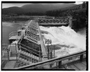 |
|
| Upriver Dam | 17.7 | 47°41′09″N 117°19′43″W / 47.68583°N 117.32861°W | 1894 / 1933 | City of Spokane | Upriver Dam Reservoir |  |
||
| Upper Falls Dam | 35 ft (11 m) | 10 | 47°39′46″N 117°24′55″W / 47.66278°N 117.41528°W | 1922 | Avista | Upper Falls Reservoir |  |
|
| Monroe Street Dam | 24 ft (7.3 m) | 15 | 47°39′42″N 117°25′31″W / 47.66167°N 117.42528°W | 1890 | Avista |  |
||
| Nine Mile Dam | 58 ft (18 m) | 26 | 47°46′30″N 117°32′38″W / 47.77500°N 117.54389°W | 1908 | Avista | Nine Mile Reservoir |  |
|
| Long Lake Dam | 213 ft (65 m) | 71 | 47°50′14″N 117°50′23″W / 47.83722°N 117.83972°W | 1915 | Avista | Long Lake |  |
|
| Little Falls Dam | 57 ft (17 m) | 36 | 47°49′57″N 117°55′04″W / 47.83250°N 117.91778°W | 1911 | Avista | Little Falls Pool |  |
Cowlitz River dams
These dams are listed from the river's start (where the Ohanapecosh River and Clear Fork of the Cowlitz River meet, Washington) to its end (Columbia River, Washington).
| Name | Height | Capacity (MW) | Province/State(s) | Coordinates | Year of completion | Owner | Reservoir formed | Image= |
|---|---|---|---|---|---|---|---|---|
| Cowlitz Falls Dam | 140 ft (43 m) | 70 | 46°27′59″N 122°06′33″W / 46.46639°N 122.10917°W | 1994 | Lewis County Public Utility District | Lake Scanewa |  |
|
| Mossyrock Dam | 606 ft (185 m) | 300 | 46°32′04″N 122°25′29″W / 46.53444°N 122.42472°W | 1968 | Tacoma Public Utilities | Riffe Lake |  |
|
| Mayfield Dam | 250 ft (76 m) | 162 | 46°30′10″N 122°35′18″W / 46.50278°N 122.58833°W | 1963 | Tacoma Public Utilities | Lake Mayfield |  |
Lewis River dams
These dams are listed from the river's start (Adams Glacier, Mount Adams, Washington) to its end (Columbia River, Washington).
| Name | Height | Capacity (MW) | Province/State(s) | Coordinates | Year of completion | Owner | Reservoir formed | Image |
|---|---|---|---|---|---|---|---|---|
| Swift Dam | 512 ft (156 m) | 240 | 46°04′48″N 122°12′36″W / 46.08000°N 122.21000°W | 1958 | PacifiCorp | Swift Reservoir | ||
| Yale Dam | 323 ft (98 m) | 134 | 45°58′48″N 122°20′24″W / 45.98000°N 122.34000°W | 1953 | PacifiCorp | Yale Lake |  |
|
| Merwin Dam | 313 ft (95 m) | 136 | 45°59′24″N 122°28′48″W / 45.99000°N 122.48000°W | 1931 | PacifiCorp | Lake Merwin |
Chelan River dams
These dams are listed from the river's start (Lake Chelan, Washington) to its end (Columbia River, Washington).
| Name | Height | Capacity (MW) | Province/State(s) | Coordinates | Year of completion | Owner | Reservoir formed | Image |
|---|---|---|---|---|---|---|---|---|
| Lake Chelan Dam | 40 ft (12 m) | 59.2 | 47°50′04″N 120°00′45″W / 47.83444°N 120.01250°W | 1892–1903 / 1927 | Chelan County Public Utility District | Raised Lake Chelan | .jpg) |
Images for kids
-
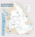
Dams of the Columbia River Basin. Click to view higher resolution and read legend.
-
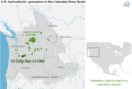
Hydroelectric generators in the basin sized by capacity. 17 dams on the British Columbia side of Canada-US border not shown.

.png)
See also
- List of lakes in Washington (state)
- List of tallest dams in the world
- Dams in the Colorado River system
- List of reservoirs and dams in the United States
- Columbia River Treaty (US–Canadian treaty regulating hydroelectric development)
