Lake Billy Chinook facts for kids
Quick facts for kids Lake Billy Chinook |
|
|---|---|

Lake Billy Chinook
|
|
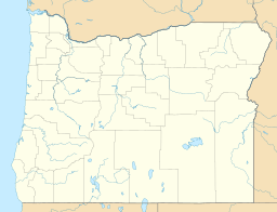
| Location | Jefferson County, Oregon |
| Coordinates | 44°35′21″N 121°21′54″W / 44.58912°N 121.36496°W |
| Type | Reservoir |
| Primary inflows | Crooked, Deschutes, and Metolius rivers |
| Primary outflows | Deschutes River |
| Catchment area | 7,514 square miles (19,500 km2) |
| Basin countries | United States |
| Max. length | 28 mi (45 km) |
| Surface area | 4,000 acres (1,600 ha) |
| Average depth | 102 ft (31 m) |
| Max. depth | 415 ft (126 m) |
| Shore length1 | 72 mi (116 km) |
| Surface elevation | 1,945 ft (593 m) |
| Islands | Chinook Island |
| Settlements | Culver |
| 1 Shore length is not a well-defined measure. | |
Lake Billy Chinook is a large lake in Jefferson County, Oregon. It's not a natural lake but a reservoir, which means it was created by building a dam. This dam, called the Round Butte Dam, was finished in 1964.
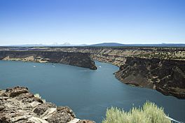
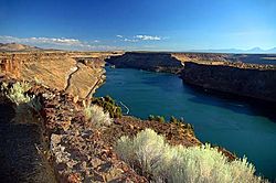
The lake sits in a deep canyon where three rivers meet: the Crooked River, the Deschutes River, and the Metolius River. It's located near the towns of Culver and Madras. The lake was named after Billy Chinook, a Native American from the Wasco tribe. He helped explorers like John C. Frémont and Kit Carson during their trips in the 1840s.
Contents
How Lake Billy Chinook Formed
The amazing canyon where Lake Billy Chinook now lies was carved out by the three rivers that flow into it. This process took millions of years! About 11 million years ago, layers of lava, river sediment, and volcanic ash flowed into the area. These layers came from the nearby Cascade Range mountains.
Later, between one and three million years ago, more lava flows covered these older layers. This created the hard "rimrock basalt" that you can still see at the top of the canyon walls. Over time, the rivers kept eroding the rock, along with wind and other volcanic activity. This ongoing process shaped the canyon into what it is today.
Exploring Lake Billy Chinook
Much of Lake Billy Chinook is surrounded by The Cove Palisades State Park. The parts of the lake where the Deschutes and Crooked Rivers flow in are inside this park. The southern shores of the Metolius River branch are public lands. These are managed by the Bureau of Land Management and the United States Forest Service. The northern shores are part of the Warm Springs Indian Reservation.
Besides the main land, there's one island in the lake called Chinook Island. There's also a large peninsula, which is a piece of land almost surrounded by water, known as "the Island."
Lake Billy Chinook is a very popular spot for fun water activities in Central Oregon. People love to go water skiing, sailing, jet skiing, and boating here. There are four places to launch boats around the lake. You can also find a marina and a café on the east shore called the Cove Palisades Resort. This resort offers houseboat and other watercraft rentals.
Just southwest of the lake, there's a small, private airport called Lake Billy Chinook Airport. It's open for public use.
Fishing at the Lake
Lake Billy Chinook is a great place to go fishing! You can catch different types of fish here, including brown trout, smallmouth bass, rainbow trout, and Kokanee. Kokanee are a type of salmon that live their whole lives in freshwater.
The lake is also special because it's one of the few places in the United States where you can legally fish for bull trout. Bull trout are a threatened species, but they are doing well in Lake Billy Chinook.
As of 2014, the Metolius River part of the lake is closed to fishing. You need a special permit from the local tribes to fish there.
The Cove Palisades State Park Fun
Most of Lake Billy Chinook is surrounded by The Cove Palisades State Park. This state park is open all year for day visits. It also offers places to camp and stay overnight.
The Cove Palisades has two campgrounds:
- The Crooked River Campground is open all year. It's located higher up in the canyon.
- The Deschutes Campground is open from mid-May to mid-September. It's close enough to walk to the water.
The Island: A Special Place
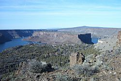
Between the Deschutes and Crooked River parts of the lake, there's a large, isolated area called "the Island." This peninsula is about 208 acres (84 hectares) in size and is about 1.75 miles (2.8 km) long. It's surrounded on three sides by very tall cliffs, ranging from 200 to 700 feet (60 to 210 meters) high above the water.
The Bureau of Land Management (BLM) named the Island a Research Natural Area in 1986. This means it's a special place for studying nature. In 1997, the BLM closed the Island to the public. However, schools and groups that work to protect nature can still visit between May and mid-February.
Because of its steep cliffs, farm animals have almost never grazed on the Island. The only time sheep grazed there was for one season in 1921. This means the Island has some of the last undisturbed plant communities in the United States. These include special types of western juniper, big sagebrush, and bluebunch wheatgrass.
The Island is also home to the striped whiptail lizard. This lizard usually lives in the deserts of the Southwestern United States. It's thought they ended up on the Island after escaping from a recreational vehicle!
The Island hasn't had a big wildfire in over a hundred years. This has allowed many woody plants to grow strong there. The BLM plans to let any future fires burn naturally as part of their research. However, they will only do this if the weather is safe and if they can stop the fire from spreading to the Cove Palisades State Park facilities below.
In 2011, U.S. Secretary of the Interior Ken Salazar officially named the Island a National Natural Landmark. It is one of only eleven such landmarks in Oregon.
 | Laphonza Butler |
 | Daisy Bates |
 | Elizabeth Piper Ensley |


