
Central Oregon facts for kids
Quick facts for kids
Central Oregon
|
|
|---|---|
|
Region
|
|

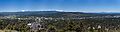
Panorama of Prineville in Crook County, and the Ochoco Mountains.
|
|
 |
|
| Country | United States |
| State | Oregon |
| Cities | Bend Madras Prineville Redmond Sisters |
| Area | |
| • Total | 7,833 sq mi (20,290 km2) |
| Population | |
| • Estimate
(2014)
|
213,578 |
| Website | www.visitcentraloregon.com |
Central Oregon is a beautiful area located in the middle of the U.S. state of Oregon. It's usually thought of as three main counties: Deschutes, Jefferson, and Crook. These three counties together are home to over 200,000 people. The biggest city in the region is Bend.
This region covers about 7,833 square miles (20,290 km²). To the west, you'll find the tall Cascades mountains. To the east are the smaller Ochoco Mountains. Central Oregon is known for its dry climate. This is because the Cascades block most of the rain. People here enjoy lots of outdoor activities. Timber (wood production) and ranching are also important jobs. Central Oregon has been a very popular place for tourists since 2012. More than 2.2 million people visited in both 2012 and 2013.
Contents
What is the Geography of Central Oregon Like?

Central Oregon is a mix of different land types. It sits where several major geological areas meet. Because of its history with volcanoes, you'll see many volcanic rock formations. These include lava beds, volcanic hills (buttes), crater lakes, and lava tubes. Deschutes County has over 500 lava tubes, making it Oregon's most cave-rich county.
The main river in Central Oregon is the Deschutes River. It starts in the Cascade Mountains. The Deschutes River flows from south to north. It eventually empties into the Columbia River. Along its way, dams create reservoirs like Crane Prairie Reservoir and Wickiup Reservoir. The river flows through Bend and past Redmond. North of Redmond, the river has carved a deep canyon. Near Madras, the Round Butte Dam creates Lake Billy Chinook.
The two largest rivers that flow into the Deschutes are the Metolius River and the Crooked River. The Metolius River starts at Metolius Springs. It flows northeast and joins the Deschutes just south of Round Butte Dam. The Crooked River flows west from the Ochoco Mountains. It joins the Deschutes from the east at Cove Palisades State Park. Both rivers become part of Lake Billy Chinook.
.jpg)
The plants in Central Oregon are mainly two types of forests. There are Ponderosa pine forests near the Cascades. To the east, you'll find smaller Western Juniper forests. The Deschutes River roughly divides these two areas. Because it's dry and hot in late summer, wildfires happen often. Small fires are good for the forest, as they clear out dead plants.
For many years, people tried to stop all fires. But this led to bigger, more dangerous wildfires. Now, local officials do "controlled burns." These are small, planned fires that help keep the forests healthy. The Oregon Badlands Wilderness is a special area. It protects the natural plants and animals of the desert basin. It's about 20 miles (32 km) east of Bend.
Most people in Central Oregon live near the rivers. Towns are built on flat areas next to rivers. Farmers use irrigation to water their fields. This helps them grow hay and other crops. It also helps with raising livestock.
A Look at Central Oregon's History
Before European settlers arrived, Native American tribes lived in Central Oregon. These included the southernmost Sahaptin tribes and the northernmost Northern Paiute tribes. In the mid-1800s, settlers came along the Oregon Trail. This led to conflicts between the tribes and the settlers.
In 1826, Peter Skene Ogden led a group of fur trappers through Central Oregon. They were the first Europeans to explore the area. Later, in 1843, Captain John C. Fremont and his U.S. Army team mapped the western part of Central Oregon. Fremont's group, including famous explorers like Kit Carson, camped near Bend.

In 1855, the Army sent another team to find a railroad route. This team surveyed the Deschutes River area. Newberry Crater is named after John Strong Newberry, who was the main scientist on this team.
In 1865, soldiers built Camp Polk. This fort was meant to protect early settlers from Native American raids. It was near where Sisters is today. But the fort was soon left empty.
After this, settlers began to claim land under the Homestead Act. They used the open lands for ranches. Prineville became the first city in the region in 1877. Sisters was founded in 1888.
In the early 1900s, new highways connected Central Oregon to the rest of the state. U.S. Route 97 linked the region to the Columbia River and Portland. Other routes connected it to the Willamette Valley.
.jpg)
The lumber industry was very important to Central Oregon's economy in the first half of the 20th century. By 1915, two large sawmills were built south of Bend. These were the Shevlin-Hixon and Brooks-Scanlon mills. Their combined production made Bend one of the world's biggest lumber towns. In 1924, the Shevlin-Hixon mill alone processed a huge amount of lumber. There were also many mills in the Prineville area.
During World War II, the need for wood grew a lot. Central Oregon mill towns became much larger. After the war, many mills eventually closed. The last big mill in Bend closed in the early 1950s. The last mill in Sisters closed in 1963.
Central Oregon's Ecology: Plants and Animals

Central Oregon has many different natural areas. These include high mountains, conifer forests, river areas, high desert, and dry, flat lands.
Unlike the wetter areas west of the Cascades, the plants and animals here are tougher. They have adapted to the dry climate. Trees like the ponderosa pine have thick bark. This bark helps them keep water and protects them from fires. Ponderosa pine cones actually need the heat of small fires to open. Other common plants include black sagebrush and cheatgrass. You can also find many different kinds of wildflowers.
Mammals in Central Oregon
You can find many large mammals in Central Oregon. These include American black bears, cougars, bobcats, coyotes, and different types of foxes. You might also see mule deer, black-tailed deer, Rocky Mountain elk, pronghorn, and bighorn sheep.
Smaller mammals are also common. These include beavers, raccoons, weasels, otters, and minks. You might also spot black-tailed jackrabbits, mountain cottontails, and different kinds of squirrels and chipmunks.
Birds of Prey and Other Birds

Central Oregon is home to many birds of prey. There are twelve types of hawks and eagles, and five types of falcons. Some examples are bald eagles, golden eagles, red-tailed hawks, and American kestrels.
Thirteen types of owls live here, including barn owls and great horned owls. Turkey vultures are also common. You can find seven types of woodpeckers, like the downy woodpecker. Many smaller birds also live in the woodlands. These include larks, tanagers, swallows, jays, crows, and chickadees.
Reptiles and Amphibians
Nine types of snakes live in Central Oregon. These include the western rattlesnake, gopher snake, and common garter snake. There are also many turtles, lizards, and frogs. You might see western pond turtles, sagebrush lizards, and Cascades frogs.
Historically, salmon used to swim up the local rivers from the Pacific Ocean. However, many dams on the Columbia River have reduced the number of ocean-going fish.
What is the Climate Like in Central Oregon?
Central Oregon is very dry and sunny. This is because the Cascade mountains create a "rain shadow." This means the mountains block most of the rain from reaching the area. The region gets about 300 sunny days each year, which is a big reason why people love it.
Summer temperatures usually range from 45 to 85 degrees Fahrenheit (7 to 29 degrees Celsius). Winter months are colder, averaging between 20 and 40 degrees Fahrenheit (-6 to 4 degrees Celsius). Most of the rain falls as snow in winter. Snowfall can range from 8 to 22 inches (20 to 56 cm). Winter snow can be tricky because it often melts and refreezes, creating layers of ice. This makes the snow heavy and hard to clear.
How Does Central Oregon's Economy Work?

Central Oregon's economy depends a lot on timber (wood), ranching, and outdoor recreation. Much of the area is covered in forests. Even though logging has slowed down, it's still important. Many areas are used for raising livestock. There are also many chances for outdoor fun.
The Deschutes National Forest covers about 1.8 million acres (7,300 km²). It's located along the east side of the Cascade mountains. The Ochoco National Forest is north and east of Prineville. It covers about 850,000 acres (3,400 km²). These two national forests provide timber and recreation. They help many local businesses and support jobs for over 50,000 people.
Outdoor Activities and Resorts
Central Oregon is full of recreational activities. Both summer and winter sports bring many visitors. In winter, people enjoy skiing, snowboarding, cross-country skiing, and snowmobiling. In summer, popular activities include water skiing, boating, fishing, hiking, and rock climbing. Because of its many rivers, lakes, and mountains, Central Oregon is called an "outdoor playground."
The region has five special "destination resorts." These include Brasada Ranch, Sunriver, Pronghorn, Eagle Crest Resort, and Black Butte Ranch. These resorts are big employers in the area. Mount Bachelor ski area is also a major attraction. It's one of the largest ski areas in the Pacific Northwest.
Tourism in Central Oregon
.jpg)
Central Oregon has a large tourism industry, especially for outdoor activities. It's also known as a great place to visit with your dog. Many hotels and restaurants welcome pets.
The region has 26 breweries, which are part of Oregon's growing craft beer scene. Other popular attractions include Oregon's Scenic Bikeways and rock climbing at Smith Rock State Park. You can also go mountain biking on over 700 miles (1,100 km) of trails. Hiking is popular at Cascade Lakes, the Deschutes River, and near the Three Sisters volcanoes.
Water sports like rafting, kayaking, and swimming are popular on the many lakes and rivers. You can also shop tax-free at boutiques and malls. There are museums like The Museum at Warm Springs and the High Desert Museum.
Events and Festivals
Central Oregon hosts many events all year long. There are 10 annual craft beer festivals. These include Winterfest in February and the Bend Brewfest in August.
Other fun events include the Sisters Rodeo and summer concerts at the Hayden Homes Amphitheater. There's also the Pacific Crest Weekend Sports Festival and The Bite of Bend food festival. You can enjoy Munch and Music in Drake Park and the Sisters Outdoor Quilt Show. The Deschutes County Fair is another big event. Many art walks and farmers markets also take place regularly.
The Deschutes National Forest has about 104 developed campsites. Many are near Bend, off the Cascade Lakes Scenic Byway.
Fly Fishing in Central Oregon
Central Oregon has been a top spot for fly fishing for a long time. In 2012, it even hosted the Fly Fishing National Championships. The Deschutes River is one of the best places for trout and steelhead fishing. Bend is a top destination for anglers (people who fish with a rod and line) in the U.S.
Some popular ponds for fly fishing include Shevlin Pond, Bend Pine Nursery Pond, and Walton Lake.
Cities in Central Oregon
| City | Population (2014) | County |
|---|---|---|
| Bend | 84,080 | Deschutes |
| Culver | 1,392 | Jefferson |
| La Pine | 1,742 | Deschutes |
| Madras | 6,533 | Jefferson |
| Metolius | 723 | Jefferson |
| Prineville | 9,258 | Crook |
| Redmond | 27,491 | Deschutes |
| Sisters | 2,224 | Deschutes |
Images for kids
-
A view from Pilot Butte, looking west at the city of Bend with the Cascade Mountains in the background.
