La Pine, Oregon facts for kids
Quick facts for kids
La Pine, Oregon
|
|
|---|---|

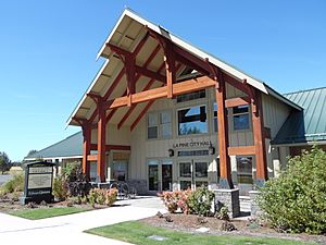
La Pine City Hall
|
|

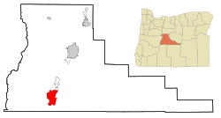
Location of La Pine, Oregon
|
|
| Country | United States |
| State | Oregon |
| County | Deschutes |
| Area | |
| • Total | 7.14 sq mi (18.49 km2) |
| • Land | 7.14 sq mi (18.49 km2) |
| • Water | 0.00 sq mi (0.00 km2) |
| Elevation | 4,236 ft (1,291 m) |
| Population
(2020)
|
|
| • Total | 2,512 |
| • Density | 351.92/sq mi (135.88/km2) |
| Demonym(s) | Lapinese |
| Time zone | UTC-8 (Pacific (PST)) |
| • Summer (DST) | UTC-7 (PDT) |
| ZIP code |
97739
|
| Area code(s) | 541 |
| FIPS code | 41-41050 |
| GNIS feature ID | 1144724 |
| Website | www.lapineoregon.gov |

La Pine is a city located in Deschutes County, Oregon, in the United States. It officially became a city on December 7, 2006.
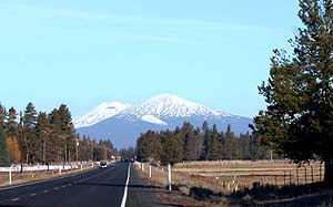
La Pine is part of the larger Bend, Oregon area. In 2020, about 2,512 people lived there. The city is in a quiet part of Central Oregon, with many homes and businesses along U.S. Highway 97. It's about 30 miles (48 km) southwest of Bend. You can see several tall mountains from the Cascade Range nearby.
The city is in the valley of the Little Deschutes River. This river is a smaller stream that flows into the Deschutes River. The river is a great place for fun activities like fishing, swimming, and canoeing.
Contents
History of La Pine
The first European-American settlers came to this area in the 1800s. They were French fur trappers. La Pine was founded in the 19th century, with Huntington Road as its main street.
The community was first called Rosland. A post office opened there in 1897, and a town was planned in 1900. In 1908, work began on the Oregon Trunk Railroad. This railway line later became part of the BNSF Railway.
What is now U.S. 97 was finished in 1917. For many years, La Pine was an unincorporated community. This means it didn't have its own city government.
In 2000, a new branch of the Deschutes Public Library was built in La Pine. People voted in 2000 on whether to become an official city, but they said no.
However, in 2006, another vote was held. This time, the people of La Pine voted yes to become a city! When it became a city in December 2006, it had 1,585 residents. The city covers about 7 square miles (18 km2).
Geography of La Pine
La Pine covers an area of about 6.98 square miles (18.1 km2). All of this area is land.
Getting Around La Pine
The main road in La Pine is U.S. Route 97. It runs north and south through the entire city. Oregon Route 31 starts about 1 mile (1.6 km) south of the city.
A train line, owned by Burlington Northern Santa Fe Railway, also runs through La Pine. It goes alongside U.S. 97.
Population and People
| Historical population | |||
|---|---|---|---|
| Census | Pop. | %± | |
| 2010 | 1,653 | — | |
| 2020 | 2,512 | 52.0% | |
| U.S. Decennial Census | |||
Who Lives in La Pine?
In 2020, there were 2,512 people living in La Pine. There were 1,226 homes.
Age and Movement
Most people in La Pine are adults, with 83.3% being 18 years or older. About 20.4% of people are 65 or older. Around 16.7% of the people are under 18 years old.
Many people have moved to La Pine from nearby areas. Some moved from other parts of Oregon, and a few from other states.
Backgrounds and Languages
Many people in La Pine have Irish or German family backgrounds. Some also have English, Norwegian, or Italian roots. Most people speak English at home.
Education and Work
About 9.6% of people in La Pine have a bachelor's degree or higher. Many others have finished high school or attended some college. Most students in La Pine are in kindergarten through 12th grade.
About 11.6% of people in La Pine are military veterans. This is higher than the average for all of Oregon.
The median household income in La Pine was $37,979 in 2020. Most workers are employed by private companies. Some work for the government, and others are self-employed.
La Pine in 2010
In 2010, there were 1,653 people living in La Pine. The city had 698 households.
Most people in La Pine were White (93.5%). A small number were Native American or from other backgrounds. About 5.8% of the population was Hispanic or Latino.
The average age in La Pine was 43.6 years. About 22.4% of residents were under 18 years old.
Education
Schools in La Pine, like La Pine Senior High School, are part of the Bend-La Pine School District.
See also
 In Spanish: La Pine para niños
 | John T. Biggers |
 | Thomas Blackshear |
 | Mark Bradford |
 | Beverly Buchanan |

