
Deschutes River (Oregon) facts for kids
Quick facts for kids Deschutes River |
|
|---|---|

The Deschutes River near its mouth on the Columbia. Pioneers camped on the bluff to the left.
|
|

Map of the Deschutes watershed
|
|


Location of the mouth of the Deschutes River in Oregon
|
|
| Country | United States |
| State | Oregon |
| County | Deschutes, Jefferson, Sherman, and Wasco |
| Physical characteristics | |
| Main source | Little Lava Lake Cascade Range, Deschutes County, Oregon 4,747 ft (1,447 m) 43°54′33″N 121°45′40″W / 43.90917°N 121.76111°W |
| River mouth | Columbia River between Fairbanks and Biggs Junction, on border between Wasco and Sherman counties, Oregon 164 ft (50 m) 45°38′07″N 120°54′52″W / 45.63528°N 120.91444°W |
| Length | 252 mi (406 km) |
| Basin features | |
| Basin size | 10,500 sq mi (27,000 km2) |
| Type: | Scenic, Recreational |
| Designated: | October 28, 1988 |
The Deschutes River is a big river in central Oregon, USA. It's a main branch of the Columbia River. This river helps drain the eastern side of the Cascade Range mountains in Oregon. It collects water from many smaller streams that flow down from the drier eastern slopes.
For thousands of years, the Deschutes River was a key travel route for Native Americans. Later, in the 1800s, pioneers used it on the Oregon Trail. The river mostly flows through wild, dry lands. Its valley is an important cultural area for central Oregon. Today, the river provides water for irrigation (watering crops). It's also a popular spot for summer activities like whitewater rafting and fishing. Like other big Oregon rivers, the Deschutes flows mainly north before joining the Columbia River.
Contents
Journey of the Deschutes River
The Deschutes River starts at Little Lava Lake. This natural lake is in the Cascade Range, about 26 miles (42 km) northwest of La Pine.
River's Path from Source to Mouth
The river first flows south into Crane Prairie Reservoir. Then it goes into Wickiup Reservoir. From there, it turns northeast, passing by the town of Sunriver. It then reaches the city of Bend, which is about 170 miles (270 km) from where the river ends.
In Bend, the river flows into Mirror Pond. This pond was created by a hydroelectric dam. It's a beautiful part of several parks in Bend. During warmer months, some of the river's water is sent to canals for irrigation. This reduces the flow between Bend and Pelton Dam.

The river continues north from Bend, flowing west of Redmond, Oregon. It passes places like Eagle Crest Resort and Cline Falls State Scenic Viewpoint. As it goes through Oregon's high desert, the river carves a deep gorge. This gorge has tall basalt cliffs. By the time it reaches Lake Billy Chinook, a reservoir near Madras, the river is about 300 feet (91 m) below the land around it. At Lake Billy Chinook, two other rivers, the Crooked River and the Metolius River, join the Deschutes.
After the dam at Lake Billy Chinook, the river stays in its deep gorge. It flows through the Warm Springs Indian Reservation. This area includes the city of Warm Springs and the Kah-Nee-Ta resort. The Deschutes River finally ends when it meets the Columbia River. This meeting point is about 5 miles (8 km) southwest of Biggs Junction.
Streams Joining the Deschutes
Many smaller streams and rivers flow into the Deschutes River along its journey.
- Near its start, streams like Snow Creek, Cultus River, Cultus Creek, and Deer Creek join it at Crane Prairie Reservoir.
- Further downstream, you'll find the Fall River, the Little Deschutes River, and the Spring River.
- Then come Tumalo Creek and Whychus Creek.
- The Metolius River and the Crooked River are major additions at Lake Billy Chinook.
- Other creeks include Seekseequa Creek, Willow Creek, Dry Hollow, Campbell, Shitike, and Trout Creek.
- The Warm Springs River also joins the Deschutes.
- Closer to the mouth, you'll find Swamp, Skookum, Oak, Antoken, Cove, Eagle, Nena, Wapinitia, Bakeoven, Spring, Oak Springs, and the White River.
- Finally, Winterwater and Elder creeks are the last to join.
History of the Deschutes River
Long ago, the Deschutes River flowed in a slightly different path. About 80,000 years ago, lava flows changed its course to where it is today.
How the River Got Its Name
French fur traders in the early 1800s named the river Rivière des Chutes. This means River of the Falls in French. They were likely referring to the Celilo Falls on the Columbia River, which was close to where the Deschutes joined it. These falls are now covered by water from a dam.
The famous explorers Lewis and Clark saw the river in 1805. They called it Towarnehiooks after a Native American name. On their way back, they renamed it Clarks River. Over time, it's also been called Chutes River and Falls River.
A Challenge for Pioneers
In the mid-1800s, the Deschutes River was a big challenge for immigrants traveling on the Oregon Trail. The main crossing point was near its mouth, in what is now the Deschutes River State Recreation Area. Many pioneers camped on a bluff (a high, steep bank) on the west side after crossing. You can still see parts of the old trail leading up the bluff today.
Dams and Railroads
In 1910, the Bend Water, Light & Power Company built a dam on the river in Bend. This created Mirror Pond and gave the city its first electricity. This dam still makes electricity for about 400 homes in Bend.
Around 1908, two railroad companies, the Deschutes Railroad and the Oregon Trunk Railway, raced to build train lines from the river's mouth to Bend. This was a big competition between two powerful railroad owners, Edward H. Harriman and James J. Hill.
In 1964, Portland General Electric (PGE) built the Round Butte Dam on the Deschutes. At the time, it was Oregon's largest hydroelectric dam. It stands 440 feet (130 m) tall and creates Lake Simtustus, a large reservoir.
Fishing in the Deschutes River
The Deschutes River is famous around the world for fly fishing. It's home to a special type of rainbow trout called "redsides" (Oncorhynchus mykiss gairdneri). These fish are known for being larger and having a distinct darker red stripe.
Where to Find Fish
Redsides are very common in the river, especially above Sherars Falls. They are strong fish because they live in such a powerful river. Most redsides caught are 8 to 15 inches (20 to 38 cm) long, but some are much bigger. You can find these redside trout throughout the river. Fishing for them is most popular from Warm Springs down to Macks Canyon. Special permits are needed if you fish from Tribal lands.
The 100-mile (160 km) stretch of river from Pelton Dam to the mouth is one of America's best trout fishing spots. It's also great for summer steelhead. This part of the river drops 1,233 feet (376 m) and carves a deep canyon.

Fly fishermen visit in late May and early June. This is when large stoneflies hatch. These insects are a major food source for the fish. Anglers often use artificial flies that look like stonefly nymphs.
People also fish for Steelhead from the river's mouth up to Round Butte Dam. Spring and fall chinook salmon are fished from the mouth to Sherars Falls. Tribal members also fish for chinook and steelhead at Sherars Falls.
Fishing in the Reservoirs
- Crane Prairie Reservoir: This reservoir offers some of Oregon's best rainbow trout fishing. Many "cranebows" (rainbow trout) here are 4-10 pounds, and some can reach 20 pounds! Other fish include brook trout, kokanee salmon, largemouth bass, black crappie, and whitefish. Boats are recommended for the best fishing.
- Wickiup Reservoir: This reservoir has many types of fish. You can find Kokanee and Coho Salmon, rainbow trout, brooke trout, whitefish, and chub. It's especially known for large brown trout, often 5-8 pounds, with some reaching over 20 pounds! It's easiest to fish from a boat here.
- Lake Billy Chinook: This lake has kokanee, bull trout, rainbow trout, brown trout, and many warm-water fish like large and small mouth bass. You can also find crayfish here. The bull trout caught in this reservoir can be very large.
How People Use the River
A lot of the water from the upper Deschutes River is sent into canals. This water is used to water farms. In summer, nearly 98% of the river's flow is used for irrigation. As cities like Bend and Redmond grow, they also need more water.
Some of the old canals lose about half their water because it seeps into the ground. There's a push to replace these canals with pipelines to save water. However, some local people don't want this because they like the historic look of the canals. Golf courses also use a lot of water, and there are 13 golf courses in the Bend, Redmond, and Sunriver areas.
Rafting and Kayaking
The Deschutes River is popular for whitewater rafting and kayaking.
- One section, called the Big Eddy, is a short part of the river upstream from Bend.
- The lower and more popular section is from Warm Springs down to just above Sherars Falls. The busiest part is about 4 miles (6.4 km) above Maupin to just above Sherars Falls.

Images for kids
-
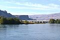
The Deschutes River near its mouth on the Columbia. Pioneers camped on the bluff to the left.
-
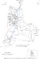
Map of the Deschutes watershed
See also
 In Spanish: Río Deschutes para niños
