
Sherman County, Oregon facts for kids
Quick facts for kids
Sherman County
|
|
|---|---|

Sherman County Courthouse in Moro
|
|

Location within the U.S. state of Oregon
|
|
 Oregon's location within the U.S. |
|
| Country | |
| State | |
| Founded | February 25, 1889 |
| Named for | William T. Sherman |
| Seat | Moro |
| Largest city | Wasco |
| Area | |
| • Total | 831 sq mi (2,150 km2) |
| • Land | 824 sq mi (2,130 km2) |
| • Water | 7.5 sq mi (19 km2) 0.9%% |
| Population
(2020)
|
|
| • Total | 1,870 |
| • Estimate
(2023)
|
1,951 |
| • Density | 2.1/sq mi (0.8/km2) |
| Time zone | UTC−8 (Pacific) |
| • Summer (DST) | UTC−7 (PDT) |
| Congressional district | 2nd |
Sherman County is one of the 36 counties in the state of Oregon. It's a small county with a population of 1,870 people, based on the 2020 census. This makes it the second-smallest county in Oregon by population. The main town and county seat is Moro, and the biggest city is Wasco. The county is named after William Tecumseh Sherman, a famous general from the American Civil War.
Contents
A Look Back: Sherman County's History
_(sheD0049).jpg)
Long ago, people called pioneers started moving to Oregon. As more people settled in western Oregon, it began to feel crowded. So, some pioneers looked for new places to live and farm in eastern Oregon, in an area called the Columbia Plateau.
The first white settler in what is now Sherman County was William Graham in 1858. More settlers, known as homesteaders, arrived in the 1880s. They came by steamboat, stagecoach, and wagons, eager to claim land. Soon, many farmers owned their own land.
As the population grew, people in this area wanted to become their own county. They were part of Wasco County before. On February 25, 1889, Sherman County was officially created from the northeast part of Wasco County. The county's boundaries have only changed once, in 1891, when a small part of Wasco County was added to Sherman County.
When the county was first formed, the town of Wasco was chosen as the county seat. However, there was a disagreement between Wasco and Moro about which town should be the county seat. After the county's borders changed, Moro eventually became the permanent county seat.
Exploring Sherman County's Geography
Sherman County is located in the north-central part of Oregon. It sits to the east of the Cascade Range mountains. The county's borders are defined by two rivers: the John Day River to the east and the Deschutes River to the west. To the north, the Columbia River forms another border.
Most of Sherman County is flat because it's part of the Columbia Plateau. The highest point in the county is about 3,004 feet (916 meters) high, but its exact location isn't known.
The United States Census Bureau says that Sherman County covers a total area of 831 square miles. Out of this, 824 square miles is land, and about 7.5 square miles (0.9%) is water.
Neighboring Counties
Sherman County shares its borders with these other counties:
- Klickitat County, Washington - to the north
- Gilliam County - to the east
- Wasco County - to the southwest and west

Who Lives in Sherman County?
| Historical population | |||
|---|---|---|---|
| Census | Pop. | %± | |
| 1890 | 1,792 | — | |
| 1900 | 3,477 | 94.0% | |
| 1910 | 4,242 | 22.0% | |
| 1920 | 3,826 | −9.8% | |
| 1930 | 2,978 | −22.2% | |
| 1940 | 2,321 | −22.1% | |
| 1950 | 2,271 | −2.2% | |
| 1960 | 2,446 | 7.7% | |
| 1970 | 2,139 | −12.6% | |
| 1980 | 2,172 | 1.5% | |
| 1990 | 1,918 | −11.7% | |
| 2000 | 1,934 | 0.8% | |
| 2010 | 1,765 | −8.7% | |
| 2020 | 1,870 | 5.9% | |
| 2023 (est.) | 1,951 | 10.5% | |
| U.S. Decennial Census 1790–1960 1900–1990 1990–2000 2010–2020 |
|||

In 2010, there were 1,765 people living in Sherman County. These people lived in 777 households, and 492 of those were families. The county had about 2.1 people per square mile. Most people living in the county were white (93.4%). Other groups included American Indian, Black, Asian, and Pacific Islander people. About 5.6% of the population was of Hispanic or Latino background.
Many people in Sherman County have German, English, or Irish family backgrounds. The average age of people living there was about 48 years old.
What Drives Sherman County's Economy?
Sherman County's economy mainly relies on farming. Farmers in the county mostly grow wheat and barley. Ranching, which is raising livestock like cattle, also helps the economy. Tourism brings some money to the area too.
The county is also home to the Biglow Canyon Wind Farm. This is a very large project that uses wind turbines to create electricity. It's the biggest wind farm of its kind in Oregon.
Towns and Communities
Sherman County has several towns and smaller communities.
Cities
- Grass Valley
- Moro (This is the county seat)
- Rufus
- Wasco
Census-Designated Place
Unincorporated Communities
These are smaller places that are not officially organized as cities:
- De Moss Springs
- Erskine
- Harmony
- Hay Canyon
- Kent
- Klondike
- Locust Grove
- Rutledge
- McDonald
- Monkland
Former Communities
These are places that used to be communities but are no longer active:
- Early
- Boardman
- Biglow
- Emigrant Springs
- Lone Rock
- Webfoot
Local Newspapers
Here are some newspapers that have been published in Sherman County:
- The Times-Journal (Current)
- Moro Bulletin
- Moro Leader (started in 1898)
- Moro Observer/Sherman County Observer (1897—1931)
- Sherman County Journal (started in 1931)
- Sherman County News (started in 1927)
Images for kids
-
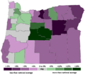
This map shows how much the population changed in Oregon counties from 2000 to 2007. Sherman County had the second-lowest growth rate.
 |
Klickitat County, Washington | |
||
| Wasco County | Gilliam County | |||
| Wasco County |
See also
 In Spanish: Condado de Sherman (Oregón) para niños
