Kent, Oregon facts for kids
Quick facts for kids
Kent, Oregon
|
|
|---|---|

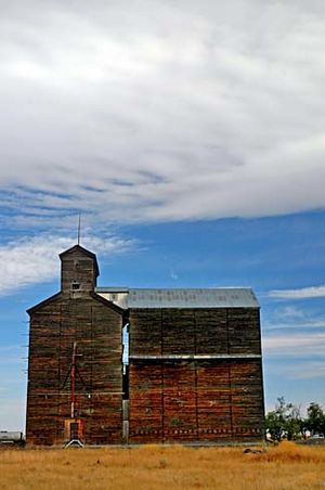
Old grain elevator in Kent
|
|
| Country | United States |
| State | Oregon |
| County | Sherman |
| Elevation | 2,713 ft (827 m) |
| Time zone | UTC-8 (Pacific (PST)) |
| • Summer (DST) | UTC-7 (PDT) |
| ZIP code |
97033
|
| Area code(s) | 458 and 541 |
| GNIS feature ID | 1122693 |
Kent is a small, quiet place in Sherman County, Oregon, United States. It's called an "unincorporated hamlet," which means it's a small community without its own local government.
In Kent, you'll find a large building for storing grain, a church, and a post office. There are also a few homes. Kent is located where two roads meet: U.S. Route 97 and Dobie Point Road. It sits between the towns of Grass Valley to the north and Shaniko to the south.
History of Kent
Kent used to be a stop on the Columbia Southern Railway. The railway station was first named Guthrie.
How Kent Got Its Name
The name "Kent" was chosen in a fun way. Local residents suggested names, and the first postmaster, Milton H. Bennett, drew one out of a hat. He started the post office around 1887. The name "Kent" was picked because it was short and easy to write.
Climate in Kent
Kent has a special kind of weather known as a steppe climate. This means it has warm, dry summers. The average monthly temperatures don't get super hot, staying below about 68 degrees Fahrenheit (20 degrees Celsius).
Weather Details
The weather in Kent is shown in the table below. It includes information like the highest and lowest temperatures ever recorded. It also shows how much rain and snow Kent usually gets each month.
| Climate data for Kent, Oregon | |||||||||||||
|---|---|---|---|---|---|---|---|---|---|---|---|---|---|
| Month | Jan | Feb | Mar | Apr | May | Jun | Jul | Aug | Sep | Oct | Nov | Dec | Year |
| Record high °F (°C) | 63 (17) |
69 (21) |
77 (25) |
89 (32) |
97 (36) |
103 (39) |
107 (42) |
108 (42) |
102 (39) |
92 (33) |
77 (25) |
65 (18) |
108 (42) |
| Mean daily maximum °F (°C) | 37.5 (3.1) |
42.9 (6.1) |
50.5 (10.3) |
57.8 (14.3) |
66.5 (19.2) |
74.2 (23.4) |
83.8 (28.8) |
83 (28) |
74.3 (23.5) |
62.4 (16.9) |
47.2 (8.4) |
39.5 (4.2) |
60 (16) |
| Mean daily minimum °F (°C) | 22.9 (−5.1) |
26.7 (−2.9) |
30.5 (−0.8) |
34.1 (1.2) |
40 (4) |
46.2 (7.9) |
52.2 (11.2) |
52 (11) |
45.9 (7.7) |
38 (3) |
30 (−1) |
25.3 (−3.7) |
37 (3) |
| Record low °F (°C) | −17 (−27) |
−19 (−28) |
5 (−15) |
14 (−10) |
21 (−6) |
26 (−3) |
32 (0) |
36 (2) |
21 (−6) |
9 (−13) |
−10 (−23) |
−18 (−28) |
−19 (−28) |
| Average precipitation inches (mm) | 1.4 (36) |
1.08 (27) |
1 (25) |
0.93 (24) |
1.02 (26) |
0.87 (22) |
0.35 (8.9) |
0.38 (9.7) |
0.57 (14) |
0.87 (22) |
1.47 (37) |
1.48 (38) |
11.42 (290) |
| Average snowfall inches (cm) | 7 (18) |
3.9 (9.9) |
2.1 (5.3) |
0.7 (1.8) |
0 (0) |
0 (0) |
0 (0) |
0 (0) |
0.1 (0.25) |
0.2 (0.51) |
2.2 (5.6) |
5.2 (13) |
21.3 (54) |
| Average precipitation days | 10 | 9 | 9 | 8 | 7 | 6 | 2 | 3 | 4 | 7 | 10 | 9 | 84 |
 | Bayard Rustin |
 | Jeannette Carter |
 | Jeremiah A. Brown |


