Wasco County, Oregon facts for kids
Quick facts for kids
Wasco County
|
|
|---|---|
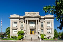
Wasco County Courthouse in The Dalles
|
|
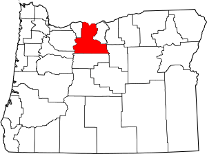
Location within the U.S. state of Oregon
|
|
 Oregon's location within the U.S. |
|
| Country | |
| State | |
| Founded | January 11, 1854 |
| Named for | Wasco people |
| Seat | The Dalles |
| Largest city | The Dalles |
| Area | |
| • Total | 2,395 sq mi (6,200 km2) |
| • Land | 2,382 sq mi (6,170 km2) |
| • Water | 14 sq mi (40 km2) 0.6%% |
| Population
(2020)
|
|
| • Total | 26,670 |
| • Estimate
(2023)
|
26,333 |
| • Density | 11.136/sq mi (4.2995/km2) |
| Time zone | UTC−8 (Pacific) |
| • Summer (DST) | UTC−7 (PDT) |
| Congressional district | 2nd |
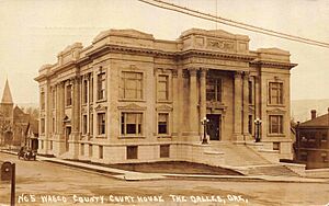
Wasco County is one of 36 counties in the state of Oregon. It is located in the northern part of Oregon, right next to the Columbia River. The county seat, which is like its main city, is The Dalles.
Wasco County is named after the Wasco people. They are a Chinook tribe of Native Americans. They have lived for a long time on the south side of the Columbia River.
Contents
Discovering Wasco County's Past
Early Native American Life
For thousands of years, Celilo Falls on the Columbia River was a very important place. It was a major gathering spot and trading center for local Native American tribes. These included the Wasco, Paiute, and Warm Springs tribes. French Canadian fur traders later called these rapids "The Great Falls of the Columbia."
The Oregon Trail and New Settlements
The Dalles first served as a stopping point for pioneers on the Oregon Trail. This trail led people toward the Willamette Valley in Oregon. In 1845, the Barlow Road was built over the Cascade Range. This made it easier for families to settle in the area. The Donation Land Claim Act of 1850 also encouraged more people to move here. Over time, Wasco County became a key hub for river and land travel.
How Wasco County Was Formed
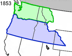
The Oregon government created Wasco County on January 11, 1854. It was formed from parts of other counties east of the Cascade Range. When it was first made, Wasco County was huge! It was one of the largest counties in the United States. It stretched all the way to the Rocky Mountains. Its northern border was the Columbia River.
Over the years, parts of Wasco County were used to create other states and counties. For example, parts became part of Dakota Territory in 1861, Idaho Territory in 1863, and Montana Territory in 1864. Other counties in Oregon were also created from its land. This is how Wasco County became its current size.
The Dalles: The County Seat
The Dalles was chosen as the county seat when Wasco County was created. It has always been the main city for the county.
Changes to the Columbia River
The building of dams greatly changed the Columbia River. The Bonneville Dam was built in 1935. Later, The Dalles Dam was built in 1957 within Wasco County. This dam caused Celilo Falls to be covered by water.
The Rajneeshpuram Movement
In the 1980s, Wasco County gained international attention. A group led by Bhagwan Shree Rajneesh started a community called Rajneeshpuram. It was on a ranch known as "The Big Muddy." The group had disagreements with the county government and local residents. These issues were about rules for building and land use.
Followers of Rajneesh, called Rajneeshees, moved into Antelope, Oregon. They were able to elect most of the town's leaders. The Rajneeshees also invited many homeless people from across the U.S. to live at Rajneeshpuram. Many people thought this was an attempt to gain control of the county through voting.
In 1984, there was an unusual event. Some people became sick after eating at restaurants in The Dalles. It was found that this was caused by the actions of some Rajneeshees.
Rajneesh left the U.S. in 1985. He and some followers faced legal issues related to immigration. Other Rajneeshees faced charges in Wasco County. Rajneesh agreed to leave the country as part of a legal agreement.
Today, the former Rajneesh ranch is called "Washington Family Ranch." It is run by Young Life Ministries. This is a Christian group that offers camp services for young people.
Exploring Wasco County's Geography
Wasco County covers about 2,395 square miles. Most of this is land, with a small amount of water. The northern border of the county is the Columbia River. This river also forms the state line with Washington.
Neighboring Counties
Wasco County shares its borders with several other counties:
- Klickitat County, Washington (to the north)
- Sherman County, Oregon (to the east)
- Gilliam County, Oregon (to the east)
- Wheeler County, Oregon (to the southeast)
- Jefferson County, Oregon (to the south)
- Marion County, Oregon (to the southwest)
- Clackamas County, Oregon (to the west)
- Hood River County, Oregon (to the west)
Protected Natural Areas
Part of the Mount Hood National Forest is located within Wasco County. This is a large area of protected land.
People and Population
| Historical population | |||
|---|---|---|---|
| Census | Pop. | %± | |
| 1860 | 1,689 | — | |
| 1870 | 2,509 | 48.5% | |
| 1880 | 11,120 | 343.2% | |
| 1890 | 9,183 | −17.4% | |
| 1900 | 13,199 | 43.7% | |
| 1910 | 16,336 | 23.8% | |
| 1920 | 13,648 | −16.5% | |
| 1930 | 12,646 | −7.3% | |
| 1940 | 13,069 | 3.3% | |
| 1950 | 15,552 | 19.0% | |
| 1960 | 20,205 | 29.9% | |
| 1970 | 20,133 | −0.4% | |
| 1980 | 21,732 | 7.9% | |
| 1990 | 21,683 | −0.2% | |
| 2000 | 23,791 | 9.7% | |
| 2010 | 25,213 | 6.0% | |
| 2020 | 26,670 | 5.8% | |
| 2023 (est.) | 26,333 | 4.4% | |
| U.S. Decennial Census 1790–1960 1900–1990 1990–2000 2010–2020 |
|||
As of the 2010 census, there were about 25,213 people living in Wasco County. The population density was about 10.6 people per square mile. Most of the people living in the county were white (86.1%). About 14.8% of the population was of Hispanic or Latino background.
The average age of people in Wasco County was 41.7 years. About 29.3% of households had children under 18 living with them. The average household had 2.44 people.
The median household income was $42,133. This means half of the households earned more than this, and half earned less. About 15.5% of the population lived below the poverty line.
Wasco County's Economy
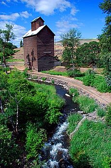
The economy of Wasco County relies on several key areas. These include:
- Agriculture: This means growing crops like wheat and fruit in orchards. It also includes raising livestock.
- Lumber: Working with wood from trees.
- Manufacturing: Making goods in factories.
- Electric Power: Generating electricity, often from dams.
- Transportation: Moving goods and people.
- Tourism: Visitors coming to see the area.
In the past, making aluminum was a big part of the local economy. However, changes in electricity prices and global aluminum prices led to some factories closing.
Communities in Wasco County
Wasco County has several towns and cities.
Cities and Towns
Other Communities
There are also smaller communities in the county. Some of these are:
- Chenoweth
- Pine Grove
- Pine Hollow
- Rowena
- Sportsmans Park
- Tygh Valley
- Wamic
- Bakeoven
- Boyd
- Celilo Village
- Criterion
- Endersby
- Fairbanks
- Friend
- Kingsley
- Nansene
- Ortley
- Rice
- Simnasho
- South Junction
- Wapinitia
See also
 In Spanish: Condado de Wasco para niños
 | Kyle Baker |
 | Joseph Yoakum |
 | Laura Wheeler Waring |
 | Henry Ossawa Tanner |


