
Bonneville Dam facts for kids
Quick facts for kids Bonneville Locks and Dam |
|
|---|---|

The spillway helps control the flow of water.
|
|
| Location | Columbia River Gorge National Scenic Area, Multnomah County, Oregon / Skamania County, Washington, United States |
| Coordinates | 45°38′39″N 121°56′26″W / 45.64417°N 121.94056°W |
| Construction began | 1934 (First Powerhouse) 1974 (Second Powerhouse) |
| Opening date | 1937 (First Powerhouse) 1981 (Second Powerhouse) |
| Construction cost | $88.4 million (First Powerhouse, Spillway, Lock and Fish structures) $664 million (Second Powerhouse) |
| Owner(s) | US Army Corps of Engineers (Operator) Bonneville Power Administration (Marketer) |
| Dam and spillways | |
| Type of dam | Concrete gravity, run-of-the-river |
| Impounds | Columbia River |
| Height | 171 ft (52 m) |
| Length | 2,690 ft (820 m) |
| Width (base) | 132 ft (40 m) (Spillway) |
| Spillway type | Service, gate-controlled |
| Reservoir | |
| Creates | Lake Bonneville |
| Total capacity | 537,000 acre⋅ft (0.662 km3) |
| Catchment area | 240,000 sq mi (620,000 km2) |
| Power station | |
| Turbines | 20 and unit 0 |
| Installed capacity | 1242 MW |
| Annual generation | 4,466 GWh (2009) |
|
Bonneville Dam Historic District
|
|
| Location | Bonneville, Oregon |
| Built | 1934–1943 |
| Architect | Claussen and Claussen |
| Architectural style | Colonial Revival |
| NRHP reference No. | 86000727 (original) 86003598 (increase) |
| Significant dates | |
| Added to NRHP | April 9, 1986 |
| Boundary increase | March 26, 1987 |
| Designated NHLD | June 30, 1987 |
The Bonneville Lock and Dam is a large dam complex that stretches across the mighty Columbia River, connecting the states of Oregon and Washington. Located about 40 miles (64 km) east of Portland, Oregon, this dam is a key landmark in the beautiful Columbia River Gorge.
The dam has two main jobs. First, it generates clean energy called hydroelectricity by using the power of flowing water. Second, it acts like a water elevator for ships, allowing them to navigate the river safely. It's a "run-of-the-river" dam, which means it doesn't store huge amounts of water but uses the river's natural flow to make power.
The United States Army Corps of Engineers built and manages the dam. When construction started in the 1930s, it was a massive project for the country. The dam is named after Captain Benjamin Bonneville, an army officer who explored and mapped parts of the famous Oregon Trail. Because of its importance, the area was named a National Historic Landmark District in 1987.
Contents
Why Was the Dam Built?
.jpg)
.jpg)
.jpg)

Before the Bonneville Dam, ships had trouble passing a rough section of the river called the Cascades Rapids. A smaller canal and lock system was built in 1896 to help, but a bigger solution was needed.
In the early 1930s, the United States was in the Great Depression, a time when many people were out of work. President Franklin D. Roosevelt started a program called the New Deal to create jobs and help the economy. Building huge projects like the Bonneville Dam was part of this plan.
Construction began in 1934. The project gave jobs to about 3,000 people who worked in shifts around the clock. Building the dam not only provided jobs but also promised to control floods and create inexpensive electricity for the Pacific Northwest.
How the Dam Was Constructed
To build the dam, engineers first had to clear a dry area in the middle of the river. They used temporary walls called cofferdams to hold back the water. This allowed workers to build the foundation on the riverbed.
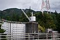
The first parts completed were a powerhouse for generating electricity and a lock for ships on the Oregon side of the river. On the Washington side, they built a spillway, which is a set of large gates that can be opened to release extra water. These main structures were finished in 1937.
The dam created a large reservoir behind it, known as Lake Bonneville. This new lake submerged the old rapids and the original 1896 canal.
Upgrades and Changes Over Time
The dam was a huge success, but as time went on, it needed updates.
- A Second Powerhouse: To generate even more electricity, a second powerhouse was built on the Washington side between 1974 and 1981.
- A New Lock: The original ship lock from 1938 was the highest in the world when it was built. But as bigger ships began using the river, it became too small. A new, larger lock was built and opened in 1993. The old lock is still there but is no longer used.
The Dam by the Numbers
The Bonneville Lock and Dam is made of several key parts:
- First Powerhouse: Built from 1933 to 1937. It has 10 generators that can produce up to 526.7 megawatts of power.
- Spillway: Built from 1933 to 1937. It has 18 huge gates to control the water level.
- Second Powerhouse: Built from 1974 to 1982. It has 8 main generators and can produce up to 558.2 megawatts.
- Bonneville Lock: The new lock, built from 1987 to 1993, is 86 feet (26 m) wide and 675 feet (206 m) long. It takes a boat about 30 minutes to pass through.
- Lake Bonneville: The reservoir created by the dam is 48 miles (77 km) long.
- Total Power: Together, both powerhouses can generate about 1.2 gigawatts of electricity, enough to power thousands of homes.
Wildlife at the Dam
Building a dam on a river can change the environment for fish and other animals. The Bonneville Dam has special features to help local wildlife.
Helping Fish Swim Upstream
The Columbia River is famous for its salmon and steelhead trout. These fish swim from the ocean up the river to lay their eggs. The dam is a giant wall in their path, so engineers built fish ladders.
A fish ladder is like a staircase for fish. It's a series of small pools, each one slightly higher than the last. Fish can jump from one pool to the next, allowing them to get past the dam and continue their journey upstream. There are even underwater viewing windows where visitors can watch the fish swim by.
The dam also created challenges for other species, like the white sturgeon. These large, ancient fish could no longer reach their spawning grounds upstream. However, a healthy population of sturgeon still lives and spawns in the river below the dam.
Sea Lions and Other Animals
The large number of fish trying to get past the dam attracts predators. California sea lions often gather at the base of the dam to hunt for an easy meal. This has become a concern for scientists who worry about the impact on the salmon population.
Next to the dam is the Bonneville Fish Hatchery, the largest in Oregon. It raises young salmon to be released into the river and is a popular tourist spot.
Gallery
-
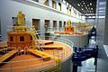
Generators inside the second powerhouse
-

View inside of powerhouse two of Bonneville Dam
-
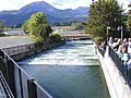
A fish ladder at Bonneville Dam
-
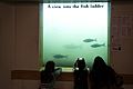
Children watch fish through a viewing window
-

A Pacific lamprey, another fish that uses the ladders, attached to the glass
-
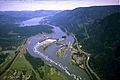
Aerial view showing the spillway, powerhouses, and lock
-
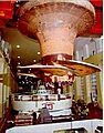
A Bonneville Dam Kaplan turbine after 61 years of service
-
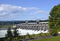
View of Bonneville Dam
-
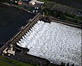
The spillway from the air
-
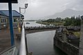
A swing bridge opens for a barge at the navigation locks
-
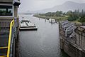
The bridge is fully open as the barge approaches
-
The downstream gates of the old, unused navigation lock
-
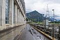
A view of the first powerhouse
-
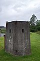
A guardhouse built during World War II for protection
-
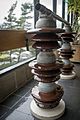
Equipment at the visitors center that helps manage electricity
-
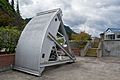
A Tainter valve, used to control water flow at the locks
-
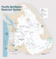
A map of the river system in the Pacific Northwest
-
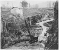
An old photo showing the excavation for the navigation lock


See also
- Grand Coulee Dam, another major dam on the Columbia River
- List of dams in the Columbia River watershed
