
Lake Bonneville facts for kids
Quick facts for kids Lake Bonneville |
|
|---|---|

Map of Lake Bonneville, showing the outline of the Bonneville shoreline, the highest level of the lake. [figure prepared by Oviatt, C.G., 2019; a similar map was published in reference 3].
|
|

Lake Bonneville
Location in the United States
|
|
| Location | Utah, Idaho, Nevada |
| Coordinates | 41°N 113°W / 41°N 113°W |
| Type | pluvial lake (a paleolake created by a change in water balance in the basin) |
| Etymology | Benjamin Bonneville |
| Surface area | ~51,000 km2 (20,000 sq mi) (at max. lake level) |
| Max. depth | over 300 m (980 ft) |
Imagine a giant lake that once covered a huge part of what is now Utah, Idaho, and Nevada. This was Lake Bonneville, the largest ancient lake in the Great Basin of western North America. It existed during the last major Ice Age, a long time ago.
Lake Bonneville was a type of lake called a pluvial lake. This means it formed because there was more rain and less evaporation due to cooler temperatures. At its biggest, Lake Bonneville was almost as large as modern Lake Michigan. Today, the Great Salt Lake, Utah Lake, and Sevier Lake are what's left of this massive ancient lake.
Contents
What Lake Bonneville Looked Like

If you look closely at the mountains around Salt Lake City in Utah, you can still see signs of Lake Bonneville. These signs are like shelves or benches on the mountainsides. They show where the lake's edges were at different times. You can see them from far away or even on satellite images!
Scientists have named three main shorelines: Stansbury, Bonneville, and Provo. The Bonneville shoreline shows the lake at its highest point. At its maximum size, Lake Bonneville was more than 300 m (980 ft) (about 984 feet) deep. It covered nearly 51,000 km2 (20,000 sq mi) (about 19,691 square miles). This huge lake had many islands and peninsulas, making its shoreline very interesting.
Why the Lake Grew and Shrank
Lake Bonneville existed between about 30,000 and 13,000 years ago. This was a time when many glaciers around the world were much larger than they are today. However, Lake Bonneville was not directly fed by these huge ice sheets.
For most of its life, Lake Bonneville had no river flowing out of it. So, its water level changed because of climate change. When there was more rain and less evaporation, the lake level rose. When it got drier and warmer, the lake level fell. It was all about the balance of water coming in versus water going out.
How Lake Bonneville Got its Name
The name "Lake Bonneville" was given by a famous geologist named G.K. Gilbert. He named it after Benjamin Bonneville, a French-born officer in the United States Army. Benjamin Bonneville was an explorer and fur trapper in the American West.
Interestingly, Captain Bonneville probably never actually saw the Great Salt Lake or the Great Basin. G.K. Gilbert's important work on Lake Bonneville, published in 1890, helped us understand this ancient lake. Scientists are still studying Lake Bonneville today to learn even more about its history.
The Lake's Amazing History
Lake Bonneville started to grow about 30,000 years ago. It slowly rose until about 18,000 years ago. At this point, it reached its highest level, which we call the Bonneville shoreline. The water became so high that it started to overflow!
The overflow happened near Red Rock Pass in what is now southeastern Idaho. The water began to trickle out, but it quickly turned into a massive flood. This event is known as the Bonneville Flood.
The Great Bonneville Flood
The Bonneville Flood was incredibly powerful. It rushed down the Marsh Creek valley into the Portneuf River, then into the Snake River, and finally into the Columbia River and the Pacific Ocean. This huge flood probably lasted less than a year.
During the flood, about 1,200 cu mi (5,000 km3) (1,200 cubic miles) of water poured out of the lake. The flood was so strong that it carved deep channels into the land. It caused the lake level to drop by about 430 ft (130 m) (426 feet).
After the flood, water continued to flow out of the lake for about 3,000 years. During this time, another important shoreline formed, called the Provo shoreline. This shoreline is special because it has thick layers of a mineral called tufa.
The Lake Shrinks
Around 15,000 years ago, the climate changed again. It became warmer and drier. This meant more water evaporated from the lake than flowed in. So, Lake Bonneville began to shrink.
By 13,000 years ago, the lake had fallen to a level similar to the modern Great Salt Lake. The lake dropped about 660 ft (200 m) (656 feet) in just 2,000 years! This was about two-thirds of its maximum depth.
Even though the Great Salt Lake is part of the same water system, we use the name "Lake Bonneville" for the period from 30,000 to 13,000 years ago. After that, it's called the "Great Salt Lake."
What We Find in Lake Bonneville Sediments
Scientists study the sediments (layers of mud and sand) left behind by Lake Bonneville. These sediments are often called "Bonneville marl." This marl is mostly made of tiny particles of calcium carbonate, a mineral that settled out of the lake water.
The Bonneville Flood also left a special layer of sediment. This "flood bed" is different from the layers above and below it. It's made of sandier material and shows signs of strong currents. Because this layer formed in less than a year, it helps scientists know exactly when the flood happened (about 18,000 years ago).
How the Earth's Surface Changed
The weight of the huge Lake Bonneville actually pushed down the Earth's crust! This process is called Isostasy. When the lake dried up, the crust slowly bounced back up.
Because of this, the old shorelines of Lake Bonneville are not perfectly flat today. They are higher in places where the lake was deepest and pushed down the crust the most. For example, the Bonneville shoreline is 243 ft (74 m) (243 feet) higher in the Lakeside Mountains than it is at Red Rock Pass.
Clues from Fossils and Ash
Besides the shorelines and sediments, scientists find other clues about Lake Bonneville:
- Fish bones and scales: These tell us about the water's physical and chemical features.
- Pollen: Tiny bits of pollen from ancient plants are found in the marl.
- Invertebrate fossils: Shells of creatures like mollusks and ostracodes.
- Mammal bones: Bones of extinct mammals from the Ice Age are found in the area.
- Volcanic ash: Layers of ash from ancient volcanoes help scientists date the different layers of sediment and understand the lake's history.
Studying Lake Bonneville helps us understand how lakes change over time. It even helps us imagine what ancient lakes on other planets, like Mars, might have been like!
Images for kids
-
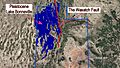
Lake Bonneville and the Wasatch Fault. Red Rock Pass is in the northeastern corner at the top of Cache Valley. The outline of the current Great Salt Lake is indicated.
-
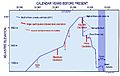
Timeline of known and suspected earthquake-induced lake level oscillations in Lake Bonneville.
-
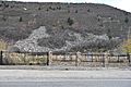
Glacial boulders swept up by the surge wave and deposited upslope on the southern lateral moraine at the mouth of Little Cottonwood Canyon. Such debris fields are known products of coastal tsunami.


See also
 In Spanish: Lago Bonneville para niños
