
Sevier Lake facts for kids
Quick facts for kids Sevier Lake |
|
|---|---|

Sevier Lake aerial view from the north
|
|

Sevier Lake
Location in Utah

Sevier Lake
Location in the United States
|
|
| Location | Millard County, Utah, United States |
| Coordinates | 38°56′20″N 113°09′43″W / 38.93889°N 113.16194°W |
| Type | intermittent endorheic |
| Primary inflows | Beaver and Sevier rivers |
| Basin countries | United States |
| Surface elevation | 4,550 ft (1,390 m) |
Sevier Lake is a special lake in Millard County, Utah. It's an intermittent lake, which means it sometimes dries up completely. It's also an endorheic lake, meaning its water stays in the area and doesn't flow out to the ocean. Sevier Lake is located in the lowest part of the Sevier Desert.
This lake is actually what's left of a much bigger, ancient lake called Lake Bonneville. Lake Bonneville existed during the Pleistocene Ice Age. Sevier Lake gets most of its water from the Beaver and Sevier rivers. It also gets water from the land around it that drains into the lake. For most of the time people have been keeping records, Sevier Lake has been dry. When it's dry, the wind can pick up dust from the lakebed, causing dust storms.
History of Sevier Lake
People first wrote about Sevier Lake in 1872. Back then, it covered about 188 square miles (490 km2). The water was very salty, about two and a half times saltier than the ocean. The deepest parts were about 15 feet (4.6 m) deep.
However, by January 1880, the lake was almost completely dry. It had been dry for a year or two before that. The Sevier River used to flow into the lake, but now much of its water is used by people for farming. In 1987, after a lot of rain, the lake looked similar to how it was described in 1872.
The Domínguez–Escalante expedition explored this area in 1776. They named the lake "Laguna de Miera" after their mapmaker, Bernardo de Miera y Pacheco. Later, in 1825, fur trappers working for William Henry Ashley visited the region. Jedediah Smith then named it Ashley Lake. On some maps from the mid-1800s, it was even named after Joseph Nicollet. Today, the lake is named after the Sevier River. The name "Sevier" comes from "Río Severo," which means "wild river" in old Spanish.
Water Levels
In late 2011, there was a lot of rain, making it an unusually wet year. Because of this, many man-made water storage areas in Millard County had too much water. They released this extra water into the Sevier River, which then flowed onto the dry bed of Sevier Lake.
For the first time since 1984, there was standing water on the lakebed. In some places, the water was over three feet deep. The water was extremely salty, with over 20% total dissolved solids (TDS). This high salt content meant the water didn't completely freeze during the winter, even when temperatures were well below 32 °F (0 °C). Only near where the Sevier River flowed into the lake did the water freeze.
Potash Mining
There's a project to mine potassium sulfate from Sevier Dry Lake. This project is being developed by a company called Crystal Peak Minerals (CPM). They have done a lot of drilling and testing all over the dry lakebed.
In 2018, CPM released a study that showed it was possible to produce potassium sulfate from the lake. This study predicted that they could produce about 298,000 metric tons of potassium sulfate each year for 30 years. The United States government approved this project in August 2019. Over its 30-year lifespan, the project could produce up to 372,000 tons of potash every year.
Climate
The climate around Sevier Dry Lake can be quite extreme. Here are some of the record temperatures and average conditions recorded between 1987 and 1993:
| Climate data for years 1987–1993 Sevier Dry Lake, Utah (elevation 4,550 ft) | |||||||||||||
|---|---|---|---|---|---|---|---|---|---|---|---|---|---|
| Month | Jan | Feb | Mar | Apr | May | Jun | Jul | Aug | Sep | Oct | Nov | Dec | Year |
| Record high °F (°C) | 68 (20) |
69 (21) |
78 (26) |
86 (30) |
91 (33) |
102 (39) |
104 (40) |
102 (39) |
94 (34) |
87 (31) |
77 (25) |
60 (16) |
104 (40) |
| Mean daily maximum °F (°C) | 35.6 (2.0) |
40.7 (4.8) |
56.6 (13.7) |
65.7 (18.7) |
75.1 (23.9) |
87.4 (30.8) |
96.2 (35.7) |
91.3 (32.9) |
82.7 (28.2) |
70.2 (21.2) |
49.5 (9.7) |
36.1 (2.3) |
65.6 (18.7) |
| Mean daily minimum °F (°C) | 8.9 (−12.8) |
13.7 (−10.2) |
30.6 (−0.8) |
35.4 (1.9) |
42.8 (6.0) |
52.1 (11.2) |
61.5 (16.4) |
56.0 (13.3) |
46.3 (7.9) |
36.4 (2.4) |
23.5 (−4.7) |
10.7 (−11.8) |
34.8 (1.6) |
| Record low °F (°C) | −18 (−28) |
−31 (−35) |
9 (−13) |
14 (−10) |
25 (−4) |
32 (0) |
49 (9) |
30 (−1) |
28 (−2) |
20 (−7) |
−7 (−22) |
−21 (−29) |
−31 (−35) |
| Average precipitation inches (mm) | 0.38 (9.7) |
0.39 (9.9) |
1.05 (27) |
0.46 (12) |
0.78 (20) |
0.56 (14) |
0.38 (9.7) |
0.75 (19) |
0.49 (12) |
0.89 (23) |
0.45 (11) |
0.36 (9.1) |
6.96 (177) |
| Average snowfall inches (cm) | 5.0 (13) |
5.3 (13) |
2.0 (5.1) |
0.0 (0.0) |
0.0 (0.0) |
0.0 (0.0) |
0.0 (0.0) |
0.0 (0.0) |
0.0 (0.0) |
0.0 (0.0) |
1.6 (4.1) |
6.9 (18) |
20.8 (53) |
| Source: The Western Regional Climate Center | |||||||||||||

Gallery
-
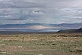
Sevier Lake after a late summer thunderstorm
-
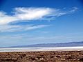
As seen from US 50 in 2009
-
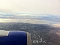
Aerial view from the east in 2011


See also
 In Spanish: Lago Sevier para niños
