
Sevier River facts for kids
Quick facts for kids Sevier River |
|
|---|---|

The Sevier River in Marysvale Canyon
|
|

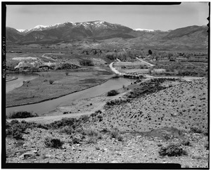
Map of the Sevier River-Sevier Lake drainage basin
|
|
| Country | United States |
| State | Utah |
| Physical characteristics | |
| Main source | Confluence of Minnie and Tyler Creeks Long Valley Junction, Kane County 7,310 ft (2,230 m) 37°30′00″N 112°30′02″W / 37.50000°N 112.50056°W |
| River mouth | Sevier Lake Southwest of Delta, Millard County 4,524 ft (1,379 m) 39°02′57″N 113°07′53″W / 39.04917°N 113.13139°W |
| Length | 385 mi (620 km) |
| Basin features | |
| Basin size | 11,574 sq mi (29,980 km2) |
| Tributaries |
|
The Sevier River (say "severe") is a 385-mile (620 km)-long river in the Great Basin area of southwestern Utah, United States. It starts near Bryce Canyon National Park. The river flows north through farming valleys and canyons. Then it turns southwest and ends in Sevier Lake in the Sevier Desert. This lake is usually dry because so much river water is used for farming.
The Sevier River's drainage basin (the area of land where all the rain and snowmelt drain into the river) is 11,574 square miles (29,980 km2) big. This covers more than 13 percent of Utah. The river's name comes from the Spanish words Río Severo, which means "violent river". The Sevier is the longest river that stays entirely within Utah.
Contents
Where Does the Sevier River Flow?
The Sevier River begins where Minnie Creek and Tyler Creek meet. This is in Long Valley in Kane County. The river's starting point is high up, at 7,310 ft (2,230 m). It flows between the Markagunt Plateau and the Paunsaugunt Plateau.
The river flows north through a wide valley. It passes through Garfield County, going by Hatch and Panguitch. Then it goes through a narrow, 5-mile (8.0 km) canyon called Circleville Canyon. It enters Piute County at Circleville. The East Fork Sevier River joins it at Kingston. Just north of Kingston, a dam creates Piute Reservoir.
The Sevier River continues north past Marysvale. It flows through Marysvale Canyon into Sevier County. At Sevier, the river enters the Sevier Valley. This is a 50-mile (80 km) long farming area. In this valley, the river flows northeast, passing many towns like Richfield and Salina. North of Sigurd, the river is dammed to form Rocky Ford reservoir. It then flows into Sanpete County. Here, it meets the San Pitch River near Gunnison.
In Juab County, the Yuba Dam creates Sevier Bridge Reservoir. This reservoir also reaches into Sanpete County. Below the dam, the river flows north, then sharply west through Leamington Canyon. It goes into Millard County. The river flows southwest across the Sevier Desert. It is used a lot for farming in the Delta area. Dams at DMAD and Gunnison Bend reservoirs hold its water. The river is usually dry for the last 30 miles (48 km) below Delta. It then reaches the often-dry Sevier Lake bed.
Understanding the Sevier River Basin
The Sevier River drainage basin is where the Basin and Range Province and the Colorado Plateau meet. The northern and western parts of the basin have long mountain ranges. These include the Pavant and Canyon Mountains. To the east and south are high plateaus and block-shaped mountains. These include the Wasatch and Sevier Plateaus. The highest point in the basin is Delano Peak at 12,174-foot (3,711 m). The lowest point is Sevier Lake, at 4,524 feet (1,379 m) above sea level.

The basin has a continental climate, from dry desert to cold mountains. Rain and snow range from 6.4 inches (160 mm) in valleys to over 40 inches (1,000 mm) in mountains. Most of the water comes from snow in winter and spring. Some also comes from summer thunderstorms. In 1999, about 823,000 acre-feet (1.015×10⁹ m3) of water flowed into the basin each year. But only about 32,900 acre-feet (40,600,000 m3) reached Sevier Lake. This was mostly in wet years. Even before farming, not all water reached the lake. This was due to a lot of evaporation in the Sevier Desert.
Most of the Sevier basin is countryside with small farming towns. The biggest town is Richfield. About 69 percent of the land is owned by the government. Much of this is in national forests like Manti-La Sal and Fishlake. The basin also includes parts of Bryce Canyon National Park. About 23 percent of the basin is privately owned.
The Sevier River area is important for travel. U.S. Route 89 follows the river for over 100 miles (160 km). I-70 also runs next to the river for about 30 miles (48 km).
How the Sevier River Basin Formed
The rocks in the Sevier River basin are mostly igneous and sedimentary. These rocks range in age from Jurassic to Quaternary periods. Underneath are older marine sedimentary rocks. These formed when western US was a shallow sea. Mountains formed between 100 and 80 million years ago. The Sevier Desert began to form about 20 million years ago. This happened as the Earth's crust stretched and lowered the land. More mountains and plateaus formed about 12–2 million years ago.
There are large cracks in the Earth's crust called faults. The Sevier Fault and Elsinore Fault run along the upper Sevier River. The Sevier Valley is a sunken block of land between these faults. It is filled with deep soil deposits. Underground water basins hold a lot of water.

The basin has many valuable minerals. These include coal near Salina and beryllium near Delta. The dry Sevier Lake bed is a big source of salts. Historically, uranium was mined near Marysvale. The colorful Big Rock Candy Mountain near Marysvale is a famous site. Its yellow, red, and orange colors come from different minerals.
During the Pleistocene Ice Age, the Sevier River flowed into Lake Bonneville. This huge lake covered a large part of the Great Basin. The Sevier Valley was underwater up to Richfield. As the climate became drier, Sevier Lake became a separate lake. It later drained into Great Salt Lake. As Sevier Lake shrank, the river formed a large delta. This is why the town of Delta is named that way. The largest sand dunes in Utah, in Little Sahara Recreation Area, formed from Sevier River delta sand. Wind moved this sand over thousands of years.
Volcanic activity happened in the Sevier basin between 1000–1500 AD. Lava flows created Navajo Lake.
Plants and Animals of the Sevier River
Valley and Stream Habitats
The valleys of the Sevier River basin were once mostly grasslands and shrublands. Oryzopsis hymenoides (Indian ricegrass) seeds were an important food for Native Americans. Many plants here, like greasewood and saltgrass, can grow in salty soil. Farming and grazing have changed these valleys a lot. Many native grasslands are now covered by plants like Russian thistle (tumbleweed).

The Sevier River used to have many wetlands and areas along its banks. These were especially big where it met Sevier Lake. Much of this habitat is now farmland. But about 92,000 acres (37,000 ha) of wetlands still exist. The upper river and mountain streams have cutthroat trout, brook trout, and rainbow trout. Cutthroat are the only native species. The lower river has warmer water fish like brown trout and carp. Reservoirs often have walleye and yellow perch.
The Sevier River is a key water source in a desert area. Many birds use it during their migration. These include geese, ducks, and cranes. Gunnison Bend Reservoir sees thousands of snow geese each spring. Other common birds are pheasants and chukars. Birds of prey like bald eagles also live here. Animals like beaver and river otter used to be common. Predators like coyotes and cougars still live in less populated areas.
Mountain Habitats
In the high mountains and plateaus above 8,000 feet (2,400 m), you'll find forests of fir, pine, spruce, and quaking aspen. Some trees like Engelmann spruce and bristlecone pine grow at the highest elevations. There are many streams and small lakes in the mountains. Large wildfires used to happen often, but they have been stopped since the 1900s.
.jpg)
Small mammals like squirrels, chipmunks, and porcupines live in the high country. Larger animals include mule deer, pronghorn, black bear, and cougar. Animals like bighorn sheep, bison, and wolves used to live here but were hunted until they disappeared. Deer populations have recovered after being very low.
The foothills have many types of plants. Small trees like gambel oak and maple grow at higher elevations. Lower down, you'll find pinyon and juniper trees mixed with grasslands.
A Look at Sevier River History
Early People and Cultures

People lived in southwestern Utah as early as 10,000 BC. The climate was much wetter then. The Sevier basin was partly covered by Lake Bonneville. Wetlands and a full Sevier River provided lots of food for people. The Desert Archaic culture followed, with small groups moving around. This culture ended around 1500 BC.
Around 500 AD, the Fremont culture lived in the Sevier basin. They used irrigation to grow crops like corn, beans, and squash. Fremont remains have been found near Clear Creek. This site is now Fremont Indian State Park. The Fremont culture disappeared around 1300 AD, possibly due to a long dry period.
The Ute, Southern Paiute, and Goshute peoples lived in the Sevier River basin before Europeans arrived. Their lands met at the Sevier River delta. The Utes lived along most of the Sevier River. The Paiutes lived to the south and west, and the Goshutes lived in drier areas.
Explorers and Traders Arrive
The first Europeans to see the river were Spanish missionaries in 1776. They were Francisco Atanasio Domínguez and Silvestre Vélez de Escalante. They named the river El Río de Santa Isabel. They named Sevier Lake Laguna de Miera. They were looking for a way to California but had to turn back.
The river became an important trade route in the late 1700s and early 1800s. Spanish traders exchanged goods for furs, hides, and horses from Native Americans. The river's current name, Sevier, likely came from Spanish traders in 1813. They called it Río Severo, meaning "violent river".
In 1821, the Sevier River basin became part of Mexico. William H. Ashley explored the area in 1825 looking for beaver. Jedediah Smith helped create a trade route through the Sevier basin in 1826. This became part of the Old Spanish Trail. John C. Frémont explored the Great Basin in 1844. He confirmed that the Sevier River did not flow to the ocean. The fur trade was very active in the 1830s and 1840s. The trade of people also happened until 1848. After the Mexican–American War, the Sevier River became part of Utah Territory.
Settlers and Conflicts
The first Mormon settlers arrived in the Sevier Valley in 1849. They soon had conflicts with Native Americans. In 1853, a group of travelers attacked some Pahvant Utes. In response, the Pahvants attacked a railroad survey crew, killing eight people. Despite this, more settlers came. By 1864, 30 Mormon families settled in Richfield.
Between 1865 and 1872, there were many fights between settlers and Native American groups. This time is called the Black Hawk War. It was named after Chief Antonga Black Hawk. Settlers' livestock ate the native grasses. These grasses were a main food source for Native Americans. This forced them to raid settlements for food. Many towns were left empty as the fighting grew. One sad event was the Circleville Massacre. In this event, 26 Paiutes were killed by settlers. In total, at least 70 settlers and many Native Americans died.
The US government stepped in, and the tribes were defeated by 1870. Most Native Americans were moved to the Uintah Reservation. Many resisted this move. By 1872, many towns were settled again. Richfield grew into the largest city in the Sevier Valley. The famous outlaw Butch Cassidy grew up on a ranch near Circleville in the 1870s.
Farming and Water Use

Farming with irrigation started along the Sevier River in 1850. The first water storage reservoir was built in 1860. In 1865, settlers dug the Richfield Irrigation Canal using only hand tools. More farming towns grew along the river after the Black Hawk War ended. A project called the Tropic Ditch moved water 15 miles (24 km) from the East Fork of the Sevier River to the town of Tropic.
Farming was hard because the Sevier River often flooded. In 1909, heavy snowmelt broke a dam and flooded the town of Deseret. By 1912, major reservoirs helped control the river. As more people came, sharing water became a problem. In a very dry year, some people even hired a group to try and remove dams upstream. Rules were set in 1900 and 1936 to share the water fairly.
Heavy water use caused Sevier Lake to dry up by 1880. Dust from the dry lake bed now causes air pollution. But the river and lake can still fill up after big floods. In 1982-1983, record snowmelt caused huge floods. Dams were damaged, and over 1.5 million acre feet of water flowed into Sevier Lake. It temporarily filled the dry lake bed 35 feet (11 m) deep.
Mining, Transportation, and Power
The Sevier basin has a long history of mining. Coal and salts have been mined near Salina since the 1870s. In 1891, the Sevier Railroad reached Salina. This made the town a shipping point for coal and farm goods. Today, much of the coal goes to the Intermountain Power Plant near Delta. This power plant uses a lot of coal and water from the Sevier River. In 2017, it was announced that the plant would switch to natural gas.
.jpg)
Gold was mined in several places along the river starting in the late 1800s. The Sevier Railroad was extended to gold mining areas like Belknap and Marysvale. Boom towns like Kimberly grew quickly.
Uranium was found in Piute County in 1948. During the 1950s and 1960s, a lot of uranium was mined near Marysvale. The mining area had many environmental issues. The state of Utah later spent money to close down two hundred mines.
Trains stopped running regularly on the Marysvale line in 1972. In 1983, floods washed out much of the tracks. The line was then closed.
Reservoirs and Dams on the Sevier River
The Sevier River has many dams and diversions. These help water more than 350,000 acres (140,000 ha) of farmland. Most of the land is used for raising cattle and turkeys. The basin is divided into upper and lower sections for water distribution. There are 175 irrigation companies that manage water use. The Sevier River Water Users Association helps regulate how water is used.
More than 1 million acre feet of water are used each year. Most of this (over 60 percent) is for farming. Water is often used more than once. This can make the water saltier in the lower river. Up to 480,000 acre-feet (590,000,000 m3) of water can be stored in reservoirs. The three largest are Sevier Bridge, Piute, and Otter Creek. They hold 75 percent of the total storage.
Otter Creek Reservoir
Smaller reservoirs were built starting in the 1860s. But by the 1890s, more water was needed. Otter Creek Reservoir was built between 1897 and 1901. It was built by ten irrigation companies. The reservoir holds water from Otter Creek. It also stores water from the East Fork Sevier River. It can hold 52,700 acre-feet (65,000,000 m3) of water.
Piute Reservoir
Piute Dam was built on the Upper Sevier River from 1908 to 1914. This created Piute Reservoir. The reservoir holds up to 71,826 acre-feet (88,596,000 m3) of water. This water is used in the Sevier Valley. Water from Piute Reservoir flows into the 65-mile (105 km)-long Sevier Valley-Piute Canal. This canal waters 20,000 acres (8,100 ha) of land.
Sevier Bridge Reservoir
By the early 1900s, the lower Sevier River often dried up. This was due to heavy farming and dry years. The Deseret Irrigation Company started building Yuba Dam in 1902. Work continued until 1907. The dam was first 60 feet (18 m) high. It was raised to 90 feet (27 m) between 1913 and 1916. Sevier Bridge Reservoir can hold 236,145 acre-feet (291,281,000 m3) of water. This makes it the fourth biggest human-made lake in Utah.
Fun Activities on the Sevier River
The upper parts of the Sevier River and its mountain streams are great for trout fishing. You can find native cutthroat trout. There are also introduced brook, brown, and rainbow trout. A 20-mile (32 km) section of the East Fork is known for excellent trout fishing. This area was restored after damage from floods in 1983. Marysvale Canyon is also good for trout fishing when the water is low. Fishing is generally not as good downstream of Marysvale Canyon. This is because the water is warmer and has more silt.
See also
 In Spanish: Río Sevier para niños
