
Richfield, Utah facts for kids
Quick facts for kids
Richfield, Utah
|
|
|---|---|

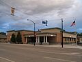
Sevier County Courthouse
|
|
| Nickname(s):
Red Hill Country; Panoramaland
|
|

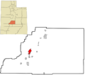
Location within Sevier County and the State of Utah.
|
|
| Country | United States |
| State | Utah |
| County | Sevier |
| Settled | 1864 |
| Founded by | Albert Lewis |
| Named for | Rich fields of wheat |
| Area | |
| • Total | 5.93 sq mi (15.36 km2) |
| • Land | 5.93 sq mi (15.36 km2) |
| • Water | 0.00 sq mi (0.00 km2) |
| Elevation | 5,354 ft (1,632 m) |
| Population
(2020)
|
|
| • Total | 8,201 |
| • Estimate
(2019)
|
7,888 |
| • Density | 1,329.96/sq mi (513.52/km2) |
| Time zone | UTC−7 (Mountain (MST)) |
| • Summer (DST) | UTC−6 (MDT) |
| ZIP code |
84701
|
| Area code(s) | 435 |
| FIPS code | 49-63570 |
| GNIS feature ID | 1444889 |
Richfield is a city in Sevier County, Utah, United States. It is the main city and county seat for Sevier County. Richfield is also the largest city in southern-central Utah.
Contents
About Richfield

In 2020, about 8,201 people lived in Richfield. The city is located in an area called the Mormon Corridor. It is just off Interstate 70. This is about 40 miles (64 km) east of where I-70 meets Interstate 15.
Richfield is a mix of farming, shops, and industries. It has become a popular stop for tourists. This is because it is on the interstate freeway, about halfway between Los Angeles, California and Denver, Colorado. Many travelers stop here.
Richfield is far from bigger cities like Salt Lake City, which is over 100 miles (160 km) away. But many smaller towns are nearby, such as Sigurd and Glenwood. Because of its location on major roads, Richfield is like the main city for central Utah. People from the area come to Richfield to shop, bowl, golf, see shows, or go to religious events. They also visit the Snow College campus and get medical care here. Richfield is part of "Panoramaland," a gateway to several nearby national parks and national forests.
Richfield's History
Early People and Explorers
People lived in the Richfield area for over 7,000 years before it became a city. Signs of the Fremont culture have been found here. These date from about 1 CE to 1000 CE.
In 1776, Father Escalante and his Spanish explorers passed through the area. They were looking for a path between New Mexico and California. Later, in the 1820s, fur traders like Jedediah Smith traveled through. The area was also part of the Old Spanish Trail from 1830 to 1850.
Founding the City
In January 1864, a group of ten men led by Albert Lewis came from Sanpete County, Utah. They arrived in what is now Richfield. These Mormon settlers found good soil, water, and wood. They decided it was a great place to build a town.
The pioneers built a simple shelter for all ten men. They called it 'The Hole in the Ground.' It was a dugout covered with branches and a rough chimney. This dugout was on what is now Main Street. The men stayed there through the winter, planning for their families to join them.
Growth and Development
Early Mormon settlements were left in 1867 because of the Black Hawk War. But when people returned in 1871, Richfield grew into an important regional center. The arrival of the Denver and Rio Grande Railroad in 1891 helped farming and mining grow in the valley.
In 1939, Utah Governor Henry H. Blood did not approve a plan for a junior college in Richfield. Fifty-seven years later, Snow College opened a campus in Richfield. About 600 students attend this campus each year.
Religion in Richfield
Like many rural areas in Utah, The Church of Jesus Christ of Latter-day Saints (LDS Church) is very important here. The early Mormon settlers worked hard to build towns. From 1847 to 1877, they founded 360 towns. Following directions from Brigham Young, Latter-day Saints founded Richfield about 150 years ago. Most people living in Richfield are members of the LDS Church.
Even though it is a strong Mormon area, people who are not Mormon or who are less active in the church also hold elected positions. Because of the area's traditional rural culture and the influence of the Latter-day Saints, most voters in Richfield support the Republican Party.
The Richfield area has about 20 different churches. These include The Church of Jesus Christ of Latter-day Saints, St. Elizabeth Catholic Church, First Baptist Church, Jehovah's Witnesses, Good Shepherd Lutheran Church, and Assembly of God.
Geography and Climate
Where is Richfield?
Richfield covers about 5.3 square miles (13.7 km2) of land. It is located 5,280 feet (1,609 meters) above sea level.
The city is easy to reach by major roads. It is located along Interstate 70. Interstate 15 is only about 30 minutes away. Richfield is about 159 miles (256 km) from Salt Lake City and 164 miles (264 km) from St. George.
Weather in Richfield
Richfield has a cold semi-arid climate with four clear seasons. This means it's usually dry, but not a desert.
- Winter: High temperatures are often in the 30s and 40s Fahrenheit (around 0-10°C). Lows are in the teens and twenties Fahrenheit (around -10 to -5°C). Snow is common but often melts quickly.
- Summer: Days are warm, with July highs usually in the 90s Fahrenheit (around 32-37°C). Sometimes it gets close to 100°F (38°C). Nights are cooler, usually in the 50s or 60s Fahrenheit (around 10-20°C). From July to September, thunderstorms bring over a third of the yearly rainfall.
- Frost: Because of its dry air and high altitude, Richfield usually gets its first frost by late September and its last in late May.
The hottest temperature ever recorded in Richfield was 104°F (40°C) in July 1931 and 1939. The coldest was -33°F (-36°C) in February 1989. Richfield gets about 8.12 inches (206 mm) of rain each year. The average snowfall is about 17.8 inches (45 cm).
| Climate data for Richfield, Utah (Richfield Radio KSVC), 1991–2020 normals, extremes 1893–present | |||||||||||||
|---|---|---|---|---|---|---|---|---|---|---|---|---|---|
| Month | Jan | Feb | Mar | Apr | May | Jun | Jul | Aug | Sep | Oct | Nov | Dec | Year |
| Record high °F (°C) | 71 (22) |
75 (24) |
81 (27) |
90 (32) |
103 (39) |
101 (38) |
104 (40) |
103 (39) |
99 (37) |
90 (32) |
80 (27) |
73 (23) |
104 (40) |
| Mean maximum °F (°C) | 56.0 (13.3) |
62.6 (17.0) |
71.9 (22.2) |
78.7 (25.9) |
87.1 (30.6) |
93.9 (34.4) |
98.3 (36.8) |
95.5 (35.3) |
90.2 (32.3) |
82.0 (27.8) |
69.9 (21.1) |
58.3 (14.6) |
98.7 (37.1) |
| Mean daily maximum °F (°C) | 41.0 (5.0) |
47.3 (8.5) |
57.5 (14.2) |
64.0 (17.8) |
73.2 (22.9) |
84.6 (29.2) |
90.4 (32.4) |
88.4 (31.3) |
80.7 (27.1) |
67.7 (19.8) |
53.2 (11.8) |
41.0 (5.0) |
65.8 (18.8) |
| Daily mean °F (°C) | 29.0 (−1.7) |
34.5 (1.4) |
42.4 (5.8) |
47.8 (8.8) |
56.2 (13.4) |
65.6 (18.7) |
72.0 (22.2) |
70.2 (21.2) |
61.8 (16.6) |
49.9 (9.9) |
38.3 (3.5) |
28.6 (−1.9) |
49.7 (9.8) |
| Mean daily minimum °F (°C) | 17.0 (−8.3) |
21.7 (−5.7) |
27.2 (−2.7) |
31.7 (−0.2) |
39.3 (4.1) |
46.6 (8.1) |
53.7 (12.1) |
52.2 (11.2) |
42.9 (6.1) |
32.0 (0.0) |
23.4 (−4.8) |
16.2 (−8.8) |
33.7 (0.9) |
| Mean minimum °F (°C) | −1.8 (−18.8) |
4.9 (−15.1) |
14.4 (−9.8) |
19.0 (−7.2) |
26.3 (−3.2) |
35.0 (1.7) |
43.0 (6.1) |
42.6 (5.9) |
30.2 (−1.0) |
18.0 (−7.8) |
7.0 (−13.9) |
−2.6 (−19.2) |
−8.5 (−22.5) |
| Record low °F (°C) | −28 (−33) |
−33 (−36) |
−12 (−24) |
5 (−15) |
14 (−10) |
20 (−7) |
30 (−1) |
22 (−6) |
12 (−11) |
0 (−18) |
−15 (−26) |
−32 (−36) |
−33 (−36) |
| Average precipitation inches (mm) | 0.55 (14) |
0.45 (11) |
0.69 (18) |
0.59 (15) |
0.97 (25) |
0.43 (11) |
0.65 (17) |
0.71 (18) |
0.79 (20) |
0.88 (22) |
0.48 (12) |
0.61 (15) |
7.80 (198) |
| Average snowfall inches (cm) | 4.3 (11) |
3.4 (8.6) |
2.0 (5.1) |
0.6 (1.5) |
0.1 (0.25) |
0.0 (0.0) |
0.0 (0.0) |
0.0 (0.0) |
0.0 (0.0) |
0.3 (0.76) |
2.4 (6.1) |
4.7 (12) |
17.8 (45.31) |
| Average precipitation days (≥ 0.01 in) | 5.2 | 5.6 | 6.1 | 6.8 | 6.6 | 3.4 | 5.7 | 6.9 | 4.9 | 6.0 | 4.8 | 5.2 | 67.2 |
| Average snowy days (≥ 0.1 in) | 2.5 | 2.1 | 1.3 | 0.6 | 0.1 | 0.0 | .00 | 0.0 | 0.0 | 0.3 | 1.5 | 2.5 | 10.9 |
| Source 1: NOAA | |||||||||||||
| Source 2: National Weather Service | |||||||||||||
Population and People
| Historical population | |||
|---|---|---|---|
| Census | Pop. | %± | |
| 1870 | 4 | — | |
| 1880 | 1,197 | 29,825.0% | |
| 1890 | 1,531 | 27.9% | |
| 1900 | 1,908 | 24.6% | |
| 1910 | 2,602 | 36.4% | |
| 1920 | 3,303 | 26.9% | |
| 1930 | 3,067 | −7.1% | |
| 1940 | 3,584 | 16.9% | |
| 1950 | 4,212 | 17.5% | |
| 1960 | 4,412 | 4.7% | |
| 1970 | 4,471 | 1.3% | |
| 1980 | 5,482 | 22.6% | |
| 1990 | 5,593 | 2.0% | |
| 2000 | 6,847 | 22.4% | |
| 2010 | 7,551 | 10.3% | |
| 2020 | 8,201 | 8.6% | |
| U.S. Decennial Census | |||
According to the census of 2010, there were 7,551 people living in Richfield. The city had about 1,425 people per square mile (551 per km2). Most people in Richfield are White (94.41%). Other groups include Native American (3.29%) and African American (0.39%). About 2.35% of the population was Hispanic or Latino.
In 2000, 44% of households had children under 18. Most households (66.2%) were married couples. The average household had about 3 people. The average family had about 3.5 people.
The population was spread out by age:
- 35.4% were under 18
- 10.8% were 18 to 24
- 22.7% were 25 to 44
- 17.0% were 45 to 64
- 14.1% were 65 or older
The average age in the city was 29 years old. For every 100 females, there were about 97 males.
The average income for a household was $36,024. For a family, it was $40,284. About 9.3% of the population lived below the poverty line. This included 10.5% of those under 18.
Richfield's population has grown in every census since 1940.
Economy
Richfield has several major employers. These include Walmart, Sevier Valley Hospital, and Lin's Fresh Market. The forest headquarters for Fishlake National Forest is also a big employer. There are also many smaller businesses, restaurants, and hotels.
The local newspaper is called The Richfield Reaper.
Transportation

Interstate 70 and U.S. Route 89 are the main highways that serve Richfield. Other state routes like Utah State Route 118 and Utah State Route 119 connect Richfield to nearby towns. Utah State Route 120 is a business loop that goes through the city.
Richfield also has bus service from Greyhound. You can travel to Denver and Las Vegas, Nevada from here.
The Richfield Municipal Airport is located one mile southwest of the city.
Education
Richfield is part of the Sevier School District. The city has two elementary schools, Ashman and Pahvant. There is one middle school, Red Hills, and one high school, Richfield High. There is also an alternative high school called Cedar Ridge.
For higher education, Richfield has a campus of Snow College.
Notable People
Many interesting people have connections to Richfield:
- Edward O. Anderson — An architect for the LDS Church.
- Theodore Brandley — A former mayor of Richfield. He helped start the agricultural village of Stirling, Alberta, Canada.
- Jake Garn — A U.S. Senator from Utah. He was the first member of the United States Congress to fly in space.
- Joseph Hansen — He was a secretary and bodyguard for Leon Trotsky in Mexico.
- Walter Frederick Morrison — The inventor of the Frisbee.
- Howard C. Nielson — A member of the U.S. House of Representatives and the Utah State Legislature.
- Cornelius Salisbury — A painter.
- Mary Thurman — An actress and silent film star.
Images for kids
-
Sevier County Courthouse
-
Location within Sevier County and the State of Utah.
-
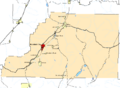
Richfield is highlighted in red
-
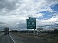
A sign for Exit 37 and Business Loop 70 and SR-120, August 2013
See also
 In Spanish: Richfield (Utah) para niños
