
Stirling, Alberta facts for kids
Quick facts for kids
Stirling
|
|||
|---|---|---|---|
|
Village
|
|||
| Village of Stirling | |||

Galt Historic Railway Park north of Stirling.
|
|||
|
|||
| Nickname(s):
The Junction Town (1912)
Village of Gardens A Town of Two Towns |
|||
| Motto(s):
Experience The History
|
|||

Stirling
Location in Alberta
|
|||
| Country | Canada | ||
| Province | Alberta | ||
| Region | Southern Alberta | ||
| Census division | 2 | ||
| Municipal district | County of Warner No. 5 | ||
| Founded | May 5, 1899 | ||
| Incorporated | |||
| • Village | September 3, 1901 | ||
| Area
(2021)
|
|||
| • Land | 2.7 km2 (1.0 sq mi) | ||
| Elevation | 935 m (3,068 ft) | ||
| Population
(2021)
|
|||
| • Total | 1,164 | ||
| • Density | 431.8/km2 (1,118/sq mi) | ||
| Time zone | UTC−7 (MST) | ||
| • Summer (DST) | UTC−6 (MDT) | ||
| Postal code span |
TOK 2EO
|
||
| Area code(s) | +1-403 | ||
| Highways | Highway 4 Highway 61 Highway 846 |
||
| Waterways | Etzikom Coulee Kipp Coulee Stirling Lake Milk River Ridge Reservoir |
||
| Historic Sites | Galt Historic Railway Park Michelsen Farmstead William T. Ogden House |
||


Stirling is a small village in southern Alberta, Canada. It is surrounded by the County of Warner No. 5. The village is located on Highway 4. It is about 31 kilometers (19 miles) southeast of Lethbridge. It is also about 72 kilometers (45 miles) northwest of the Canada–US border.
Stirling is also known as Stirling Agricultural Village. This is because it is a National Historic Site of Canada.
Contents
History of Stirling


In the 1880s, railways were built across Southern Alberta. The Canadian Pacific Railway (CPR) built a line from Calgary to Fort Macleod. The Alberta Railway and Coal Company (ARCC) built a smaller railway. This line went from Lethbridge to Medicine Hat to supply coal to the CPR.
In 1899, the ARCC built another railway. This one went from Lethbridge, Alberta, to Great Falls, Montana. It followed the old Whoop-up Trail. This railway was built to sell coal in Montana, not for new settlers.
The first station south of Lethbridge was at "18 Mile Lake." This was a stop for trains to get water. The station was named after J. A. Stirling, a person who helped fund the ARCC. At first, only railway workers lived there.
The Alberta Railway & Coal Company owned a lot of dry land in Southern Alberta. This land was mostly good for ranching. Not many settlers wanted to farm there.
The company saw how the Church of Jesus Christ of Latter-day Saints (LDS Church) used irrigation in Utah and nearby Cardston, Alberta. So, in 1899, they asked the LDS Church to help settle the area.
The agreement said the LDS Church and the Alberta Railway & Irrigation Company would build an irrigation canal. They would also create two communities: Stirling and Magrath. After the St. Mary's Irrigation Canal was finished, the Church received thousands of acres of land. This land was given to missionaries who worked on the canal.
With irrigation arriving on November 14, 1899, Stirling quickly grew next to the railway station. Today, the St. Mary's Main Canal is 312 kilometers (194 miles) long. It still provides water for farming in Southern Alberta.
Why Stirling is a National Historic Site
On May 5, 1899, about 30 Mormon settlers arrived at Stirling station. They were led by Theodore Brandley from Utah. Charles Ora Card from Cardston greeted them.
The next day, Brandley and Card planned the new town of Stirling. Like many Mormon settlements, Stirling was designed using Joseph Smith's "Plat of Zion" plan. The village was originally one square mile (640 acres). It had 47 blocks and 1 "Reserved" block.
Each block was divided into 8 lots, each about 1.2 acres. A wide street, 100 feet (30 meters) wide, with an irrigation canal, surrounded each block. Stirling is special because each block also has a 20-foot (6-meter) wide alleyway. This gives every home access to a back alley.
Stirling also has a unique Town Square in the northeast corner. This location was chosen because it was closest to the original railway station. The "Plat of Zion" usually put the town square in the center. The plan allowed residents to have large gardens and raise animals. Because of this, Stirling was known as the "Village of Gardens." These canals were used until 1968. That's when the village installed fresh drinking water and sewer lines.
Stirling is known as the best-preserved Mormon settlement in Canada. It still follows the "Plat of Zion" plan. Because of this, Stirling was named a National Historic Site of Canada on June 22, 1989.
Stirling is one of only two communities created by a partnership between the Church of Jesus Christ of Latter-day Saints and Charles A. Magrath of the Alberta Railway & Coal Company.
The Story of New Stirling (Maybutt)

The St. Mary Railway from Stirling to Cardston was built between 1900 and 1902. In 1912, the Canadian Pacific Railway (CPR) took over the Alberta Railway and Irrigation Company. The CPR then started building a new line east of Stirling to Saskatchewan. Stirling became an important railway junction with lines going in all directions.
The CPR needed more space for train yards. The original station area was too small. So, the CPR moved the station one mile north. This new spot was perfect for a new town. A town site was planned and lots were sold in what was called "New Stirling."
Because people got confused between the two post offices, "New Stirling" was renamed Maybutt. Mr. Fisher, who planned the town, named it after his wife, Mrs. "May Butt."
A large hotel, the Prairie Queen Hotel, a Presbyterian Church, and many other businesses and homes quickly appeared. The community even had its own newspaper, the "New Stirling Star." However, the town did not grow much. Buildings were moved away, and the school was never built. By the 1950s, the post office closed.
Maybutt slowly became a forgotten ghost town. Few original buildings remain. In recent years, some homes have been moved to Maybutt for small farms.
Geography and Climate
Stirling is located in the County of Warner No. 5. It is 31 kilometers (19 miles) southeast of Lethbridge. It sits where Highway 4 and Highway 846 meet. The Milk River Ridge is south of the village. Etzikom Coulee and Kipp Coulee are north of it.
| Coordinates: | 49°30′N 112°31′W / 49.500°N 112.517°W |
|---|---|
| Elevation | 935 metres (3,068 ft) |
| Land Area | 2.64 square kilometres (1.02 sq mi) |
Weather in Stirling
Stirling has a semi-arid climate. This means it is quite dry. Stirling also experiences chinooks. These are warm winds that can raise winter temperatures above 10 °C (50 °F). Chinooks bring more than 200 days of wind each year.
| Climate data for Stirling | |||||||||||||
|---|---|---|---|---|---|---|---|---|---|---|---|---|---|
| Month | Jan | Feb | Mar | Apr | May | Jun | Jul | Aug | Sep | Oct | Nov | Dec | Year |
| Record high °C (°F) | 16.7 (62.1) |
21.8 (71.2) |
23.3 (73.9) |
31.1 (88.0) |
34.2 (93.6) |
38.3 (100.9) |
39.4 (102.9) |
38.9 (102.0) |
36.7 (98.1) |
31.7 (89.1) |
22.8 (73.0) |
19.6 (67.3) |
39.4 (102.9) |
| Mean daily maximum °C (°F) | −1.8 (28.8) |
1.5 (34.7) |
6 (43) |
12.9 (55.2) |
18.2 (64.8) |
22.3 (72.1) |
25.5 (77.9) |
25.4 (77.7) |
20.1 (68.2) |
14 (57) |
4.3 (39.7) |
−0.2 (31.6) |
12.3 (54.1) |
| Daily mean °C (°F) | −7.8 (18.0) |
−4.6 (23.7) |
−0.2 (31.6) |
6.0 (42.8) |
11.3 (52.3) |
15.5 (59.9) |
18.0 (64.4) |
17.7 (63.9) |
12.6 (54.7) |
7.0 (44.6) |
−2.5 (27.5) |
−6.1 (21.0) |
5.7 (42.3) |
| Mean daily minimum °C (°F) | −13.8 (7.2) |
−10.7 (12.7) |
−6.5 (20.3) |
−0.9 (30.4) |
4.2 (39.6) |
8.6 (47.5) |
10.5 (50.9) |
10 (50) |
5.1 (41.2) |
0 (32) |
−7.2 (19.0) |
−12 (10) |
−1.1 (30.0) |
| Record low °C (°F) | −42.8 (−45.0) |
−42.2 (−44.0) |
−38 (−36) |
−25.6 (−14.1) |
−11.7 (10.9) |
−1.7 (28.9) |
0.9 (33.6) |
−1 (30) |
−9.4 (15.1) |
−26.7 (−16.1) |
−34.7 (−30.5) |
−42.8 (−45.0) |
−42.8 (−45.0) |
| Average precipitation mm (inches) | 17.6 (0.69) |
11.6 (0.46) |
24 (0.9) |
31.3 (1.23) |
53.5 (2.11) |
63 (2.5) |
47.5 (1.87) |
45.8 (1.80) |
36.9 (1.45) |
18.9 (0.74) |
16.9 (0.67) |
16.7 (0.66) |
386.3 (15.21) |
| Source: Environment Canada | |||||||||||||
Economy and Industries

Farming in Stirling
For a long time, Stirling's economy has mostly depended on agriculture (farming). The community still has strong ties to farming. It is part of the South Grow Regional Initiative. This group works to improve economic development for communities in the region.
Northeast of town is a 200-foot tall concrete terminal grain elevator. This large elevator was built in 1998 and 1999. It cost $11 million and was one of the first of its kind. It can hold 17,500 metric tonnes of grain.
Other Businesses and Activities
Stirling's location and history make tourism another important industry. Stirling has many businesses and fun activities. These include a convenience store, a grain elevator now used as a hemp plant, and a truck and tractor dealer. There is also a pool, a community-owned campground, a library, two museums, and Centennial Park.

Population of Stirling
In 2021, the Village of Stirling had a population of 1,164 people. These people lived in 360 homes. This was an increase from its 2016 population of 978. Stirling has a land area of 2.7 square kilometers (1.0 square miles). This means there were about 431.8 people per square kilometer in 2021.
Getting Around and Services
Stirling is connected to two main roads. Highway 4 goes south to Interstate 15 and north to Lethbridge. The historic Red Coat Trail, also known as Highway 61, goes east to Foremost.
Emergency services like health care and police come from the nearby town of Raymond, Alberta. Stirling has its own volunteer fire department. It has served the area since 1957. In recent years, residents have restarted a Neighborhood watch program. This group works to prevent crime and vandalism in the village.
Fun Things to Do in Stirling

Stirling has many fun places to visit. These include ball parks, a swimming pool with water slides, and a tennis court. There is also a community center with a picnic area, playgrounds, and rodeo grounds. You can find a fish pond, cafe, Bed & breakfast, and library.
The Milk River Ridge Reservoir south of Stirling is great for water activities in summer. Stirling Lake, also called Michelsen Marsh, north of Stirling, is perfect for bird watching all year.
At the east entrance of Main Street, there is a new information kiosk. It looks like an old pioneer home. Inside, you can find historical information and a map of interesting sites in Stirling.
Exploring the Mormon Trail
The village of Stirling is on the historic Red Coat Trail and Canada's Mormon Trail. You can take a self-guided tour that starts in Stirling. It follows the trail through Raymond, Magrath, and Cardston.
A group has been formed to connect these communities along the Mormon Trail. Each year, Stirling, Raymond, Magrath, and Cardston hold events like Chautauqua. These events show local talent and the history of the Mormon communities.
Museums to Visit

- Michelsen Farmstead - This is a typical farm from the early 1900s in Stirling. It was made a Provincial Historic Site of Alberta in 2001. The Stirling Historical Society keeps it looking like it did in the 1930s. You can find it at the corner of 6th Street and 2nd Avenue.
- Bishop's storehouse - Also known as Lord's storehouse. It was moved next to the Kiosk at the corner of 1st Street and 4th Avenue.
Local Fun Spots
- Stirling Lions Club Fish Pond - Fish are added every year for fishing fun. It's at the corner of 7th Street and 4th Avenue.
- Centennial Park - A community park with a swimming pool, playgrounds, tennis court, and basketball courts. It also has a reunion center, a senior citizen's center, baseball fields, and a campground.
- William T. Ogden House - A beautiful Neo-Classical style house. It is a Provincial historic site of Alberta. Around Halloween, the owners decorate the 7,000 square foot (650 square meter) house as a live haunted house. It is the largest haunted house in southern Alberta. Find it at 441 4th Street.
- Lost Frontier Mini-Railway - A small train park open for bookings from May to October. It's a very popular local attraction. The park is on the grounds of the William T. Ogden House. It also has a petting zoo, a mini village, a large Cuckoo clock, and the "world's smallest church." It's at 441 4th Street.

Yearly Events in Stirling
- Stirling Community Garage Sale (Saturday of Victoria Day weekend) - A big garage sale held by the Stirling Historical Society.
- Lions Community BBQ (June) - A community barbecue held at the Stirling Lions Hall.
- Stirling Settler Days (July) - This event celebrates Stirling's founding on May 5, 1899. It also marks the Mormon pioneers' arrival in the Salt Lake Valley. It used to be called "Pioneer Day."
- Stirling Fall Festival (September) - Held at the Michelsen Farmstead. Visitors can make rope, stick dolls, and dipped candles. There are also wagon rides and games for kids.
- Harvest Dance (October) - An old-fashioned Barn dance also held at the Michelsen Farmstead.
- Lions Christmas Dinner (November) - A community dinner with traditional home-cooked food.
- A Victorian Christmas (December) - A dinner and show at the Galt Historic Railway Park.
- Santa Claus Mansion (December) - Held at the William Ogden House. It's part of the town's Christmas lights tour.
- Christmas Lights tour (December) - A tour to see the beautiful Christmas light displays in town.
Nearby Attractions
- Devil's Coulee Dinosaur Heritage Museum: This museum in the Village of Warner has a Hadrosaur (duck-billed dinosaur) nest and embryo. It also features ancient fossils and dinosaur models.
- Galt Historic Railway Park: Located 1 kilometer (0.6 miles) north of Stirling. This museum shows what life and travel were like from the late 1880s to early 1920s. It is in a restored 1890 International Train Station from Coutts, Alberta, Canada, and Sweetgrass, Montana, USA.
- Waterton Lakes National Park: A national park in the southwest corner of Alberta, Canada. It is 40 kilometers (25 miles) west of Cardston. It borders Glacier National Park in Montana, USA. The Rocky Mountains rise suddenly from the prairies here.
- Writing-on-Stone Provincial Park: 44 kilometers (27 miles) east of Milk River. This park protects one of the largest prairie areas in Alberta. It also protects the largest collection of rock art made by Plains People. There are over 50 rock art sites with thousands of figures.
Education in Stirling

Stirling has one school, Stirling School, that teaches students from Kindergarten to grade 12. It is part of the Westwind School Division. In 2006, 322 students were enrolled.
Stirling School has several sports teams. These include volleyball, badminton, and even golf.
Sports in Stirling
In 1924, rodeo pioneer and Stirling cowboy Earl W. Bascom created rodeo's first one-hand bareback rigging. This equipment is now used worldwide. This makes Stirling known as the "Home of the Modern Rodeo Bareback Rigging." Earl Bascom is seen as a great inventor of rodeo equipment. He is called the "Father of Modern Rodeo."
The high school girls' basketball team, the Lakettes, won the 1A provincial championships in 1997, 1998, and 1999. They also placed in other provincial championships between 1996 and 2006. They won or placed second for six years in a row from 1996 to 2003.
The high school boys' basketball team, the Lakers, won the 1A provincial championships in 2001, 2003, 2006, 2007, and 2008. They placed second in three other provincial championships between 1996 and 2006.
In 2006, the Lakers won the final game 98–68 against the Youngstown Falcons. They had a season of 30 wins and 9 losses. They also won three other tournament titles. These included the 1A South Zone Title, the Picture Butte Sugar King Invitational, and the Mccoy Invitational.
The Stirling Lakers won another provincial title in 2007. They beat their rivals from Foremost in the championship game. On their way to provincials, the Lakers also became South Zone champions. In 2008, Stirling hosted the provincials and won their third provincial title in a row.
Media and Entertainment
Stirling is served by several local newspapers. These include the Westwind Weekly, Lethbridge Herald, and Prairie Post. Stirling once had its own newspaper called the Stirling Star.
Newspapers
- Lethbridge Herald
- Prairie Post - A newspaper about Alberta and southwest Saskatchewan.
- Stirling Star - Stirling's newspaper, printed in New Stirling until the late 1930s.
- Westwind Weekly - A weekly newspaper with news from Stirling and nearby communities.
Movies Filmed in the Area
- Pure Escape - A movie filmed in southern Alberta and Stirling in the 1980s.
- The Calgary Stampede - A movie filmed in 1925, starring Hoot Gibson. The palomino horses used in the film were from the Bascom Ranch of Stirling.
- RV - A movie filmed in the Vancouver area and southern Alberta, including Stirling. It was filmed from May to December 2005. It starred Robin Williams, Cheryl Hines, Joanna Levesque, Josh Hutcherson, Jeff Daniels, and Kristin Chenoweth.
Famous People from Stirling
- Earl W. Bascom (1906-1995) - Moved to Stirling in 1924. He was a rodeo pioneer and invented the modern rodeo bareback rigging. He is in cowboy halls of fame and is called the "father of modern rodeo." He was also a Hollywood actor, artist, and sculptor.
- Theodore Brandley - An LDS missionary and one of the founders of Stirling.
- Reg Kesler - A Calgary Stampede champion and member of the Canadian Professional Rodeo Hall of Fame.
- Jim Hillyer (1974–2016) - A Member of Parliament.
Images for kids
-
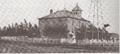
Stirling School in 1902, demolished 1957
-
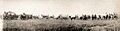
Pioneer Days Pageant, July 24, 1930, which is now known as Stirling Settler Days
