
Alberta facts for kids
Quick facts for kids
Alberta
|
|||
|---|---|---|---|
|
|||
| Motto(s):
Fortis et liber (Latin for 'strong and free')
|
|||
| Country | Canada | ||
| Confederation | September 1, 1905 (split from NWT) (10th, with Saskatchewan) | ||
| Capital | Edmonton | ||
| Largest city | Calgary | ||
| Largest metro | Calgary Region | ||
| Government | |||
| • Type | Parliamentary constitutional monarchy | ||
| Area | |||
| • Total | 661,849 km2 (255,541 sq mi) | ||
| • Land | 640,082 km2 (247,137 sq mi) | ||
| • Water | 19,532 km2 (7,541 sq mi) 3% | ||
| Area rank | Ranked 6th | ||
| 6.6% of Canada | |||
| Population
(2021)
|
|||
| • Total | 4,368,370 | ||
| • Estimate
(Q4 2025)
|
5,040,871 | ||
| • Rank | [[Population of Canada by province and territory|Ranked 4th]] | ||
| • Density | 6.82/km2 (17.7/sq mi) | ||
| Demonym(s) | Albertan | ||
| Official languages | English | ||
| GDP | |||
| • Rank | 3rd (provincial) | ||
| • Total (2023) | $459.288 billion | ||
| • Per capita | CA$ 96,576 (US$ 71,012) (2023) ([[List of Canadian provinces and territories by gross domestic product|1st (provincial), ≈12th (see: List of countries by past and projected GDP (nominal) per capita (global]]) | ||
| HDI | |||
| • HDI (2022) | 0.947 ([[List of Canadian provinces and territories by Human Development Index|1st (provincial), 8th (global) (see: List of countries by Human Development Index)]]) | ||
| Time zone | UTC−07:00 (Mountain) | ||
| • Summer (DST) | UTC−06:00 (Mountain DST) | ||
| Postal abbr. |
AB
|
||
| Postal code prefix |
T
|
||
| ISO 3166 code | CA-AB | ||
| Flower | Wild rose | ||
| Tree | Lodgepole pine | ||
| Bird | Great horned owl | ||
| Rankings include all provinces and territories | |||


Alberta is a Canadian province located in Western Canada. It is one of the three prairie provinces. Alberta shares borders with British Columbia to the west, Saskatchewan to the east, the Northwest Territories to the north, and the U.S. state of Montana to the south. Alberta and Saskatchewan are the only two Canadian provinces that do not touch an ocean.
The eastern part of Alberta features wide, flat Great Plains. The western part of the province is next to the towering Rocky Mountains. Alberta mostly has a continental climate. This means it has warm summers and cold winters. However, temperatures can change quickly because the air is often dry. These changes are less noticeable in western Alberta due to warm Chinook winds.
Alberta is the fourth largest province in Canada by land area. It is also the fourth most populated, with over 4.3 million people. Edmonton is Alberta's capital city. Calgary is its largest city. More than half of all Albertans live in these two major cities. This creates a friendly rivalry between them. English is the province's official language.
Alberta's economy is strong and diverse. It has many skilled workers and good financial systems. Most jobs are in the service sector. This includes healthcare, education, and tourism. Important industries also include manufacturing, construction, and farming. The knowledge economy is growing with many tech companies. The energy sector, especially oil and gas, is very important. It shapes the economy and exports. In 2023, Alberta's economy produced about $350 billion. This was 15% of Canada's total economic output.
Alberta is famous for its beautiful natural areas. It has many important nature reserves. It is also a great place to find fossils. Six UNESCO World Heritage Sites are located here. These include the Canadian Rocky Mountain Parks and Dinosaur Provincial Park. Other popular spots are Banff National Park and Jasper National Park.
Contents
- The Name of Alberta
- Exploring Alberta's Geography
- Alberta's Climate and Weather
- Alberta's Amazing Wildlife and Plants
- Discovering Alberta's Dinosaurs
- Alberta's Journey Through History
- Alberta's People and Cultures
- Alberta's Economy: How People Make a Living
- How Alberta is Governed
- Alberta's Culture and Fun Events
- Sports Teams in Alberta
- Learning in Alberta: Education
- Staying Healthy: Healthcare in Alberta
- Getting Around: Transportation in Alberta
- Friendship Partners Around the World
- Images for kids
- See also
The Name of Alberta
Alberta was named after Princess Louise Caroline Alberta. She was born in 1848 and passed away in 1939. Princess Louise was the fourth daughter of Queen Victoria. She was also the wife of John Campbell, who was the Governor General of Canada. Other places like Lake Louise and Mount Alberta are also named in her honor.
The name "Alberta" comes from "Albert." This was the name of Princess Louise's father, Prince Albert. The name means "noble" and "bright" or "famous."
Exploring Alberta's Geography

Alberta covers a large area of about 661,848 square kilometers. It is the fourth largest province in Canada. Alberta's southern border is at the 49th parallel north. This line separates it from the U.S. state of Montana. To the north, the 60th parallel north divides Alberta from the Northwest Territories.
The province stretches about 1,223 kilometers from north to south. It is about 660 kilometers wide at its widest point. The highest place in Alberta is Mount Columbia. It stands 3,747 meters tall in the Rocky Mountains. The lowest point is 152 meters high on the Slave River in Wood Buffalo National Park.
Alberta has many rivers and lakes. These are used for swimming, fishing, and other water sports. Some large lakes include Lake Claire, Lesser Slave Lake, and Lake Athabasca. The longest river is the Athabasca River. It flows 1,538 kilometers from the Columbia Icefield to Lake Athabasca. The Peace River is the largest river by water flow.
Alberta's capital, Edmonton, is near the center of the province. It is a major city in northern Canada. It is also a hub for developing natural resources. Calgary is about 280 kilometers south of Edmonton. It is surrounded by large ranching areas. Most of Alberta's people live in the area between Calgary and Edmonton.

The northern half of Alberta is mostly boreal forest. The Rocky Mountains in the southwest have temperate coniferous forests. The southern part of the province is prairie land. This land is used for farming and cattle ranching. The central aspen parkland region has very fertile soil. This is where most of the population lives.
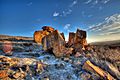
The Alberta badlands are in southeastern Alberta. Here, the Red Deer River has carved deep canyons. These areas have amazing landforms. Dinosaur Provincial Park shows off the badlands. It also has desert plants and dinosaur fossils.
Alberta's Climate and Weather

Alberta's climate changes a lot from north to south. Winters are cold, especially in the far north. Summers are warm. The Rocky Mountains affect the climate in the southwest. They block moisture from the west. This creates a rain shadow, making much of Alberta dry.
Annual rainfall is low in the southeast. It is higher in the north and in the foothills of the Rocky Mountains. Northern Alberta has a subarctic climate with boreal forests. Southern Alberta's farming areas have a semi-arid steppe climate. This means it's dry, and plants use more water than falls as rain.

Western Alberta gets warm, dry Chinook winds in winter. These winds can quickly raise temperatures. Central and northwestern Alberta have aspen parkland. This is a mix of prairie and forest. Alberta gets a lot of sunshine each year. Northern Alberta has about 18 hours of daylight in summer.
Alberta can experience strong thunderstorms in summer. It also sees about 15 tornadoes each year. The area near Calgary and Edmonton often gets hail. This is due to the nearby Rocky Mountains.
Alberta's Amazing Wildlife and Plants
Flora: Plant Life and Reproduction

In central and northern Alberta, spring brings early flowers. The prairie crocus often blooms in April. Other early flowers include the golden bean and wild rose. In summer, many types of sunflowers bloom. The southern prairies have short grasses. They also have hardy plants like the prairie coneflower and sage.
The parkland region has clumps of trees on hillsides. These are mostly deciduous trees like aspen, poplar, and willow. North of the North Saskatchewan River, you find large evergreen forests. These include jack pine, lodgepole pine, and spruce trees.
Fauna: Animal Life and Habitats

Alberta's different climates are home to many animals. The southern prairies were once home to millions of buffalo. Now, buffalo live on farms and in parks.
Herbivores like moose, mule deer, and elk live in wooded areas. Pronghorn are found in the southern prairies. Bighorn sheep and mountain goats live in the Rocky Mountains. Smaller animals like rabbits, squirrels, and skunks are found everywhere. Alberta has only one venomous snake, the prairie rattlesnake.
Large carnivores like wolves, grizzly bears, and black bears live in the mountains and forests. Smaller carnivores include coyotes, red foxes, and Canada lynx. Many birds nest in central and northern Alberta. These include ducks, geese, swans, and pelicans. Rivers and lakes have many fish like pike, walleye, and rainbow trout. The bull trout is Alberta's provincial fish.
.jpg)
Alberta is unique because it is almost completely free of Norwegian rats. Since the 1950s, the government has had a successful rat-control program. This means wild rat sightings are very rare. It is even against the law for people to own Norwegian rats in Alberta.
Discovering Alberta's Dinosaurs

Alberta is famous for its many Late Cretaceous dinosaur fossils. Scientists have found complete skeletons, bones, and even mass graves here. At least 38 different types of dinosaurs have been found in the province.
Dinosaur fossils are found in many places across Alberta. The Dinosaur Provincial Park area is especially rich in fossils. The Drumheller Valley and Edmonton regions also have many dinosaur remains. The Royal Tyrrell Museum of Palaeontology in Drumheller is a world-renowned museum. It showcases many of these amazing dinosaur discoveries.
Alberta's Journey Through History
The first people arrived in what is now Alberta over 10,000 years ago. They were Paleo-Indians who came after the last ice age. They became the various First Nations peoples. These included the Plains Indians who hunted buffalo in the south. The Woodland Cree in the north hunted and fished.
French Canadian fur traders were the first Europeans to visit Alberta in the early 1700s. The fur trade was very important. The Hudson's Bay Company and the North West Company were rival trading companies. French was a common language in early fur trading forts.

Explorers like Peter Pond and Sir Alexander Mackenzie mapped the northern areas. Mackenzie was the first European to cross North America north of Mexico. In 1803, a small southern part of Alberta became part of the United States. However, it was later given to the United Kingdom in 1818.
In 1870, the land that would become Alberta was bought by Canada. It became part of the North-West Territories. Treaties were signed with First Nations. These agreements gave land to the Crown. In return, the Crown promised to support First Nations.
The District of Alberta was created in 1882. Many immigrants arrived in the late 1800s. They helped develop farming and ranching. In 1905, the Alberta Act was passed. This officially made Alberta a province. Alexander Cameron Rutherford became the first premier.
After a tough period including World War I and the 1918 flu epidemic, a huge discovery changed Alberta. In 1947, massive oil reserves were found near Leduc. This started a new era of wealth. The oil sands began to be developed in 1967.

More recently, Alberta faced some challenges. In 2013, heavy rainfall caused major floods in southern Alberta. In 2016, a large wildfire forced over 80,000 people to leave Fort McMurray. Like the rest of the world, Alberta was also affected by the COVID-19 pandemic starting in 2020.
Alberta's People and Cultures

In 2021, Alberta had a population of over 4.2 million people. The province has grown quickly since 2000. This is mainly because of its strong economy. Alberta has a young population. The average age is 36.7 years. Most people live in cities, especially in the Calgary-Edmonton area.
Languages Spoken in Alberta
English is the most common language spoken in Alberta. Many people also speak French. Other languages like Tagalog, Punjabi, Spanish, and Hindi are also common. This shows Alberta's diverse population.
Diverse Ethnic Backgrounds
Alberta has a rich mix of ethnic backgrounds. Many Albertans have roots in Western European countries. These include England, Scotland, Ireland, and Germany. More recently, people from Asia, Africa, and South America have also moved to Alberta.
Indigenous peoples are an important part of Alberta's heritage. This includes First Nations and Métis communities. Their population is growing. Many cities, like Calgary and Edmonton, have historic Chinatowns.
Religion in Alberta
About half of Albertans identify as Christian. A large number of people also say they have no religious affiliation. Other religions like Islam, Sikhism, and Hinduism are also practiced. Edmonton is home to Canada's oldest mosque, the Al-Rashid Mosque. Calgary has Canada's largest mosque, the Baitun Nur Mosque.
Alberta's Economy: How People Make a Living
Alberta's economy is strong and based on free markets. It has a highly educated workforce. Most jobs are in the service industry. However, Alberta also has important manufacturing, construction, and energy sectors. The energy sector, especially oil and gas, is very important to Alberta's economy.
Most of Alberta's exports go to the United States. These exports are mainly oil and gas. Food products and industrial goods are also important exports. In 2023, Alberta's economy produced $350 billion. This was a big part of Canada's total economy.
Historically, the fur trade was Alberta's first major economy. Then, farming and ranching became important. The Canadian Pacific Railway helped bring many settlers. In 1947, the discovery of oil made Alberta a top oil producer. The province is now working to grow other industries. These include technology, renewable energy, and tourism.
Primary Industries: Resources from the Land

Farming employs about 2% of Albertans. Alberta has over three million cattle. It produces 40% of all Canadian beef. The province also produces a lot of bison meat. Wheat and canola are major crops. Alberta leads Canada in spring wheat production.

Forestry provides many jobs and contributes billions to the economy. It uses timber for paper, wood products, and biofuels. Alberta is also Canada's leading beekeeping province. Beekeepers produce honey from flowers like clover.
Mining, not including oil and gas, employs about 4,300 people. It focuses on coal, sand, gravel, and other minerals.
Oil and Gas Extraction
Oil and gas extraction is Alberta's biggest industry. It employs about 135,000 people. This sector makes up about 27% of Alberta's economy. Alberta produces most of Canada's crude oil and natural gas. It is also a major exporter of natural gas worldwide.

The Athabasca oil sands near Fort McMurray hold huge oil reserves. These reserves are almost as large as all the conventional oil in the rest of the world. Companies use different methods to get the oil from the sands. The price of oil affects how much oil can be profitably extracted.
Secondary Industries: Making and Building Things
.jpg)
Alberta's manufacturing sector employs about 122,300 people. It makes up 5% of all jobs. This sector contributes $23.4 billion to Alberta's economy. Key areas include food manufacturing, metal products, and machinery.
The construction industry is also a major employer. It has 222,200 workers, which is 10% of Alberta's workforce. It adds $23.6 billion to the economy. This includes building homes, offices, and large engineering projects. The utilities sector, which provides electricity, also employs many people.
Tertiary Industries: Services for Everyone
Alberta's service sector employs about 80% of its people. These jobs are in many areas. They include retail, healthcare, education, and tourism. This sector makes up most of Alberta's economic activity.

Retail and wholesale trade employ about 15% of Albertans. Healthcare and social assistance is another large employer. It includes hospitals, clinics, and nursing homes. Education services also employ many people. This includes teachers and university staff.
The finance, insurance, and real estate sector is important. Professional, scientific, and technical services are growing quickly. Transportation and warehousing also provide many jobs. Public administration, arts, and food services are other key parts of the service sector.
Tourism in Alberta
.jpg)
Alberta has been a popular tourist spot for a long time. People come for skiing, hiking, and camping. They also visit places like West Edmonton Mall and the Calgary Stampede. Calgary and Edmonton each welcome over four million visitors every year.
Banff National Park, Jasper National Park, and the Rocky Mountains are very popular. They attract about three million people annually. The scenic Icefields Parkway connects Banff and Jasper. Five of Canada's UNESCO World Heritage Sites are in Alberta. These include Dinosaur Provincial Park and Head-Smashed-In Buffalo Jump.

The Calgary Stampede is a huge event. It celebrates Canada's Wild West and ranching. Over a million people visit it each year. Drumheller, known as the "Dinosaur Capital of The World," is another big draw. It is home to the Royal Tyrrell Museum of Palaeontology.
How Alberta is Governed

Alberta has a parliamentary democracy. It has one main law-making body, the Legislative Assembly of Alberta. This assembly has 87 members who are elected by the people. Local governments and school boards are also elected separately.
Charles III is the King of Canada and Alberta's head of state. His duties are carried out by the Lieutenant Governor, Salma Lakhani. The government is led by the Premier. The Premier chooses members for the Cabinet from the Legislative Assembly. Edmonton is the capital city and home to the provincial government. The current Premier is Danielle Smith. She took office on October 11, 2022.

Alberta's politics are often seen as conservative. The Progressive Conservatives governed for 44 years. In 2015, the New Democrats formed the government. This was a big change. Since 2019, the United Conservative Party has been in power.
Law Enforcement in Alberta
The Royal Canadian Mounted Police (RCMP) is responsible for policing in most of Alberta. The Alberta Provincial Police used to police the province. It was replaced by the RCMP in 1932. The Alberta Sheriffs Branch also helps with law enforcement. They handle traffic and protect the Premier.
Military Presence
Alberta has several military bases. These include CFB Cold Lake, CFB Edmonton, CFB Suffield, and CFB Wainwright. CFB Edmonton is the headquarters for the 3rd Canadian Division. CFB Suffield is Canada's largest training facility.
How Alberta Collects Money (Taxation)
Alberta gets money from different sources. These include royalties from natural resources like oil and gas. It also collects personal and corporate income taxes. Grants from the Canadian federal government help fund projects. Alberta is the only province in Canada without a provincial sales tax. Residents pay a federal sales tax of 5%.
Alberta's Culture and Fun Events

Calgary is famous for its Calgary Stampede. It is called "The Greatest Outdoor Show on Earth." This huge rodeo festival has races and competitions like bull riding. It celebrates Alberta's western heritage.
Summer brings many festivals to Alberta, especially in Edmonton. The Edmonton International Fringe Festival is one of the largest in the world. Both Calgary and Edmonton host folk music festivals. Edmonton's "heritage days" festival celebrates over 70 ethnic groups.
Alberta also has an Artist in Residence program. An artist is chosen each year to promote the arts across the province. Lauren Crazybull was Alberta's first artist in residence in 2019.
Sports Teams in Alberta
| Team | City | League | Stadium/arena | Capacity |
|---|---|---|---|---|
| Edmonton Oilers | Edmonton | National Hockey League | Rogers Place | 18 347 |
| Calgary Flames | Calgary | National Hockey League | Scotiabank Saddledome | 19 289 |
| Edmonton Elks | Edmonton | Canadian Football League | Commonwealth Stadium | 60 081 |
| Calgary Stampeders | Calgary | Canadian Football League | McMahon Stadium | 40 000 |
| Calgary Wranglers | Calgary | American Hockey League | Scotiabank Saddledome | 19 289 |
| Calgary Hitmen | Calgary | Canadian Hockey League | Scotiabank Saddledome | 19 289 |
| Edmonton Oil Kings | Edmonton | Canadian Hockey League | Rogers Place | 18 347 |
| Lethbridge Hurricanes | Lethbridge | Canadian Hockey League | Enmax Centre | 5 479 |
| Medicine Hat Tigers | Medicine Hat | Canadian Hockey League | Canalta Centre | 7 100 |
| Red Deer Rebels | Red Deer | Canadian Hockey League | Peavey Mart Centrium | 7 111 |
| Cavalry FC | Calgary | Canadian Premier League | ATCO Field | 6 000 |
| Calgary Surge | Calgary | Canadian Elite Basketball League | Winsport Event Centre | 2 900 |
| Edmonton Stingers | Edmonton | Canadian Elite Basketball League | Edmonton Expo Centre | 4 000 |
| Calgary Roughnecks | Calgary | National Lacrosse League | Scotiabank Saddledome | 19 289 |
| Edmonton Storm | Edmonton | Western Women's Canadian Football League | Clarke Stadium | 5 100 |
| Calgary Rage | Calgary | Western Women's Canadian Football League | Shouldice Athletic Park | 1 000 |
| Lethbridge Steel | Lethbridge | Western Women's Canadian Football League | University of Lethbridge Community Stadium | 2 000 |
| Edmonton Riverhawks | Edmonton | West Coast League | RE/MAX Field | 9 200 |
Learning in Alberta: Education
Alberta's government is in charge of education. It supports local school boards, universities, and colleges.
Elementary and Secondary Schools
Alberta has many public and separate school systems. Separate schools often have a Catholic focus. All schools follow the curriculum approved by Alberta Education. Teachers are certified by the province. Students take provincial tests and can earn high school diplomas.
Colleges and Universities

Alberta has several publicly funded colleges and universities. These include the University of Alberta and the University of Calgary. They offer many different degrees. There are also community colleges and polytechnic institutes. These schools provide specific career training and diplomas. The Banff Centre for Arts and Creativity is a special arts institution.
Staying Healthy: Healthcare in Alberta

Alberta has a publicly funded health care system. This means that health services are paid for by the government. Alberta Health Services (AHS) delivers these services. Alberta was one of the first provinces to have a public health program.
Alberta's health care budget is one of the highest per person in Canada. This helps maintain and improve health care across the province. AHS manages all public health services. It also funds ambulance services, including air ambulances.
Getting Around: Transportation in Alberta
Air Travel

Alberta has international airports in Calgary and Edmonton. Calgary International Airport is a major hub for flights. It connects to other Canadian cities, the U.S., Europe, and Mexico. Edmonton International Airport is a hub for northern Canada. It also has flights to many international destinations.
Public Transit
Major cities like Calgary and Edmonton have good public transit systems. They use buses and light rail transit (LRT). The Calgary CTrain and Edmonton LRT help many people travel each day.
Train Travel

Alberta has over 9,000 kilometers of railway tracks. These are mainly used for freight transport by companies like Canadian Pacific Kansas City and Canadian National Railway. Passenger trains like Via Rail's Canadian travel through Alberta. The Rocky Mountaineer offers scenic train tours.
In 2024, Alberta's premier announced a plan to expand passenger rail. This plan includes new services to many cities. It also aims to create intercity rail between Edmonton and Calgary.
Roads and Highways

Alberta has a large network of highways and roads. Highway 2 is the main north-south route. It connects cities like Calgary, Red Deer, and Edmonton. The section between Calgary and Edmonton is called the Queen Elizabeth II Highway.
Alberta has two main east-west highways. The southern one is part of the Trans-Canada Highway. It goes through Calgary and Banff National Park. The northern one, the Yellowhead Highway, goes through Edmonton and Jasper National Park. The Icefields Parkway is a beautiful scenic drive. It runs between Jasper and Lake Louise.
In cities, major highways are often called "trails." For example, Highway 2 is called Deerfoot Trail in Calgary. Many of these trails are named after First Nations people and tribes.
Friendship Partners Around the World
Alberta has special relationships with many places globally:
- Gangwon-do, South Korea (1974)
- Hokkaido, Japan (1980)
- Heilongjiang, China (1981)
- Montana, United States (1985)
- Jalisco, Mexico (1999)
- Alaska, United States (2002)
- Saxony, Germany (2002)
- Ivano-Frankivsk, Ukraine (2004)
- Lviv, Ukraine (2005)
- California, United States (1997)
Images for kids
-
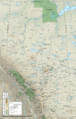
A topographic map of Alberta, showing cities, towns, and natural features.
-
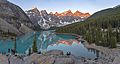
Moraine Lake at Banff National Park. The Alberta Mountain forests are found in southwestern Alberta.
-
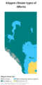
Köppen climate types in Alberta.
-
Southeastern Alberta has a dry, semi-arid steppe climate.
-
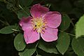
The wild rose is Alberta's provincial flower.
-
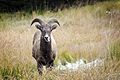
A bighorn sheep in Kananaskis Country. This is Alberta's provincial mammal.
-

An Alberta Department of Public Health rat poster from 1948.
-
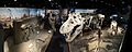
Dinosaur skeletons at the Royal Tyrrell Museum of Palaeontology.
-
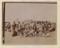
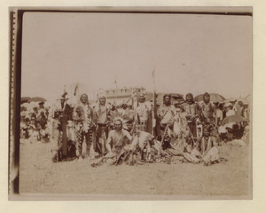
Blackfoot Confederacy warriors in Macleod in 1907.
-
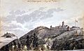
Fort Chipewyan, a trading post in 1820.
-
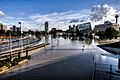
Downtown Calgary was affected by the 2013 Alberta floods.
-
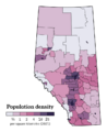
Population density of Alberta in 2021.
-
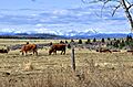
Cows in Rocky View. Alberta produces nearly half of all Canadian beef.
-
Petroleum resources in Alberta.
-
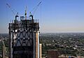
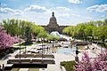
Construction in Calgary, seen from the Calgary Tower in 2010.
-
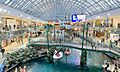
The West Edmonton Mall is one of the largest malls in the world.
-
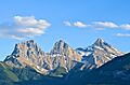
The Three Sisters at Bow Valley Provincial Park near Canmore.
-
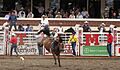
Bronco riding at the Calgary Stampede. This is one of the world's largest rodeos.
-
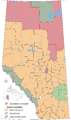
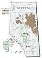
Locations of Alberta's specialized and rural municipalities.
-
The Alberta Legislative Building is where the Legislative Assembly of Alberta meets.
-
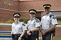
Royal Canadian Mounted Police officers in St. Albert.
-
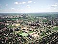
The University of Alberta in 2005. It is Alberta's oldest and largest university.
-
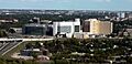
Foothills Medical Centre in Calgary is Alberta's largest hospital.
-
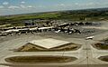
Calgary International Airport, Alberta's largest airport by passenger traffic.
-
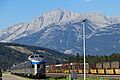
A Via Rail passenger train passing by freight trains near Jasper station.
-
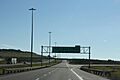
Highway 1 (the Trans-Canada Highway) at Alberta Highway 22 (Cowboy Trail).

See also
 In Spanish: Alberta para niños
- Index of Alberta-related articles
- Outline of Alberta
- Symbols of Alberta
