
Lesser Slave Lake facts for kids
Quick facts for kids Lesser Slave Lake |
|
|---|---|

Southeast corner of the lake from Marten Mountain looking south with Dog Island, Devonshire Beach, and the Town of Slave Lake visible in the distance
|
|

Lesser Slave Lake
Location in Alberta
|
|
| Location | Big Lakes / Lesser Slave River No. 124, Alberta |
| Coordinates | 55°26′26″N 115°29′19″W / 55.44056°N 115.48861°W |
| Type | Eutrophic |
| Primary inflows | South Heart River, Swan River Driftpile River, Assineau River, Marten River |
| Primary outflows | Lesser Slave River |
| Catchment area | 13,900 km2 (5,400 sq mi) |
| Basin countries | Canada |
| Max. length | +100 km (62 mi) |
| Max. width | 15 km (9.3 mi) |
| Surface area | 1,168 km2 (451 sq mi) |
| Average depth | 11.4 m (37 ft) |
| Max. depth | 20.5 m (67 ft) |
| Water volume | 13.69 km3 (11.10×10⁶ acre⋅ft) |
| Shore length1 | 247 km (153 mi) |
| Surface elevation | 578 m (1,896 ft) |
| Settlements | Slave Lake, High Prairie, Alberta |
| 1 Shore length is not a well-defined measure. | |
Lesser Slave Lake is a large lake in central Alberta, Canada. It is located northwest of the city of Edmonton. This lake is the second largest lake completely within Alberta's borders. It is also the biggest lake that you can easily reach by car.
The lake covers about 1,160 km2 (450 sq mi) of area. It is over 100 km (62 mi) long and 15 km (9.3 mi) wide at its widest point. Lesser Slave Lake is usually about 11.4 m (37 ft) deep. Its deepest spot is 20.5 m (67 ft). Water from the lake flows east into the Athabasca River. This happens through the Lesser Slave River.
Exploring Lesser Slave Lake
The town of Slave Lake is found at the eastern end of the lake. This town is right where the Lesser Slave River begins to flow out of the lake.
Images for kids
-
Lesser Slave Lake in the Center of Alberta
-
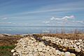
Lesser Slave Lake at Canyon Creek
-
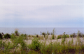
Slave Lake shoreline


See also
 In Spanish: Pequeño Lago de los Esclavos para niños
