
Slave Lake facts for kids
Quick facts for kids
Slave Lake
|
|
|---|---|
|
Town
|
|
| Town of Slave Lake | |

Main street in August 2006
|
|

Town boundaries
|
|

Slave Lake
Location in M.D. of Lesser Slave River

Slave Lake
Location in Alberta
|
|
| Country | Canada |
| Province | Alberta |
| Region | Northern Alberta |
| Planning region | Upper Athabasca |
| Municipal district | Municipal District of Lesser Slave River No. 124 |
| Incorporated | |
| • Village | January 1, 1961 |
| • Town | August 2, 1965 |
| Area
(2021)
|
|
| • Land | 14.31 km2 (5.53 sq mi) |
| Elevation | 590 m (1,940 ft) |
| Population
(2021)
|
|
| • Total | 6,836 |
| • Density | 477.7/km2 (1,237/sq mi) |
| Time zone | UTC−7 (MST) |
| • Summer (DST) | UTC−6 (MDT) |
| Postal code span |
T0G 2A0 & 2S0
|
| Area code(s) | 780, 587, 825 |
| Highways | Highway 2 Bicentennial Highway |
| Waterways | Lesser Slave Lake Lesser Slave River |
| Website | slavelake.ca |
Slave Lake is a town in northern Alberta, Canada. It's surrounded by the Municipal District of Lesser Slave River No. 124. The town is about 255 kilometers (158 miles) northwest of Edmonton. It sits on the southeast shore of Lesser Slave Lake. Two main roads, Highway 2 and Highway 88, meet here.
Slave Lake is an important center for the area. The main office for the Sawridge First Nation is also located in the town.
Contents
Exploring Slave Lake's Past
The first European to visit the Slave Lake area was David Thompson in 1799. After his visit, British agents set up several fur trading posts. One of these posts, run by the Hudson's Bay Company, was at the mouth of the lake.
A settlement grew around this trading post and was first called Sawridge. In 1923, its name was changed to Slave Lake. A big flood in the 1930s damaged much of the town. Because of this, the town was moved and rebuilt on higher ground. Slave Lake officially became a town in 1965. In July 1988, Sawridge Creek flooded the town again.
The 2011 Wildfire
On May 15, 2011, a large wildfire spread into Slave Lake. Strong winds pushed the flames, destroying many homes and businesses. Everyone in town had to leave for safety. Highways were closed, and people were told to go to beaches or large open areas. Highway 2 was closed at first but later reopened for people to evacuate.
By May 16, 2011, officials reported that about 40% of the town was destroyed or damaged. This included the town hall, the library, a radio station, a mall, and many other buildings. Luckily, no one was hurt or died in the fire. On May 17, the mayor said one-third of the town was destroyed. A few days later, on May 20, a firefighting helicopter crashed into Lesser Slave Lake, and its pilot died.
On July 6, Prince William and Catherine, who are the Duke and Duchess of Cambridge, visited Slave Lake. They came to support the residents and encourage rebuilding efforts.
Understanding Slave Lake's Climate
Slave Lake has a subarctic climate, which means it has mild summers and very long, cold winters. It's also close to a humid continental climate.
| Climate data for Slave Lake Airport | |||||||||||||
|---|---|---|---|---|---|---|---|---|---|---|---|---|---|
| Month | Jan | Feb | Mar | Apr | May | Jun | Jul | Aug | Sep | Oct | Nov | Dec | Year |
| Record high °C (°F) | 13.6 (56.5) |
14.8 (58.6) |
17 (63) |
28.6 (83.5) |
32.5 (90.5) |
33.3 (91.9) |
32.2 (90.0) |
32.3 (90.1) |
29.6 (85.3) |
28.1 (82.6) |
19.1 (66.4) |
12.4 (54.3) |
33.3 (91.9) |
| Mean daily maximum °C (°F) | −9.4 (15.1) |
−5.9 (21.4) |
1.2 (34.2) |
9.4 (48.9) |
16.1 (61.0) |
19.3 (66.7) |
21.2 (70.2) |
20.3 (68.5) |
14.6 (58.3) |
9.1 (48.4) |
−1.6 (29.1) |
−8.2 (17.2) |
7.2 (45.0) |
| Daily mean °C (°F) | −14.5 (5.9) |
−11.7 (10.9) |
−4.7 (23.5) |
3.3 (37.9) |
9.7 (49.5) |
13.6 (56.5) |
15.6 (60.1) |
14.6 (58.3) |
9.2 (48.6) |
3.8 (38.8) |
−6.1 (21.0) |
−12.9 (8.8) |
1.7 (35.1) |
| Mean daily minimum °C (°F) | −19.6 (−3.3) |
−17.4 (0.7) |
−10.6 (12.9) |
−2.9 (26.8) |
3.3 (37.9) |
7.9 (46.2) |
10.0 (50.0) |
8.8 (47.8) |
3.7 (38.7) |
−1.5 (29.3) |
−10.5 (13.1) |
−17.7 (0.1) |
−3.9 (25.0) |
| Record low °C (°F) | −42.8 (−45.0) |
−42.5 (−44.5) |
−38.3 (−36.9) |
−26.1 (−15.0) |
−7.2 (19.0) |
−2.7 (27.1) |
2.9 (37.2) |
−2.2 (28.0) |
−7.8 (18.0) |
−21.8 (−7.2) |
−36.1 (−33.0) |
−42.5 (−44.5) |
−42.8 (−45.0) |
| Average precipitation mm (inches) | 24.3 (0.96) |
17.3 (0.68) |
17.7 (0.70) |
21.4 (0.84) |
43.5 (1.71) |
88.2 (3.47) |
95.6 (3.76) |
72.5 (2.85) |
50.8 (2.00) |
27.2 (1.07) |
18.9 (0.74) |
25.2 (0.99) |
502.7 (19.79) |
| Average rainfall mm (inches) | 0.6 (0.02) |
1.0 (0.04) |
1.7 (0.07) |
12.1 (0.48) |
40.9 (1.61) |
88.2 (3.47) |
95.6 (3.76) |
72.4 (2.85) |
48.8 (1.92) |
18.0 (0.71) |
3.1 (0.12) |
2.0 (0.08) |
384.5 (15.14) |
| Average snowfall cm (inches) | 29.9 (11.8) |
21.2 (8.3) |
20.8 (8.2) |
10.4 (4.1) |
2.7 (1.1) |
0.0 (0.0) |
0.0 (0.0) |
0.0 (0.0) |
2.2 (0.9) |
9.7 (3.8) |
19.7 (7.8) |
29.8 (11.7) |
146.5 (57.7) |
| Average precipitation days (≥ 0.2 mm) | 12.0 | 10.0 | 9.2 | 7.1 | 10.5 | 14.1 | 15.0 | 12.6 | 12.6 | 10.0 | 11.3 | 12.9 | 137.3 |
| Average rainy days (≥ 0.2 mm) | 0.9 | 0.9 | 1.6 | 4.3 | 10.1 | 14.1 | 15.0 | 12.6 | 11.9 | 7.3 | 2.6 | 1.2 | 82.5 |
| Average snowy days (≥ 0.2 cm) | 12.5 | 10.2 | 8.6 | 3.6 | 1.0 | 0.0 | 0.0 | 0.0 | 1.0 | 4.5 | 10.1 | 13.0 | 64.5 |
| Average relative humidity (%) (at 3pm) | 76.2 | 71.3 | 64.1 | 51.0 | 47.5 | 55.6 | 59.0 | 59.9 | 60.5 | 59.8 | 73.7 | 77.5 | 63.0 |
| Mean monthly sunshine hours | 80.4 | 112.2 | 173.3 | 234.8 | 281.1 | 277.7 | 294.6 | 260.4 | 167.9 | 141.7 | 84.6 | 63.1 | 2,171.8 |
| Percent possible sunshine | 33.3 | 41.3 | 47.3 | 55.4 | 56.1 | 53.4 | 56.5 | 56.0 | 43.8 | 43.5 | 33.5 | 28.2 | 45.7 |
| Source: Environment Canada | |||||||||||||
How Many People Live in Slave Lake?
|
||||||||||||||||||||||||||||||||||||||||||||||||
In 2021, Statistics Canada counted 6,836 people living in Slave Lake. These people lived in 2,405 homes. This was a small increase from its 2016 population of 6,651. The town covers an area of 14.31 square kilometers (5.53 square miles). This means there were about 477.7 people per square kilometer.
In 2016, the town had 6,651 people living in 2,329 homes. This was a slight decrease from the 2011 population of 6,782.
Sports and Recreation
In 1994, Slave Lake was proud to host the Arctic Winter Games. This is a big event that celebrates sports and culture from northern regions around the world.
| Club | League | Sport | Venue | Established | Championships |
|---|---|---|---|---|---|
| Slave Lake Wolves |
|
Ice Hockey | Arctic Ice Centre |
|
|
Local Media
If you want to know what's happening in Slave Lake, you can check out a few local media sources. BOOM (FM) is a radio station that serves the area. There's also a community newspaper called the Lakeside Leader.
Images for kids
-
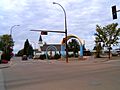
Main Street in 2006
-
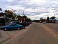
Main Street in 2006
-
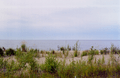
Slave Lake shoreline


