
Great Slave Lake facts for kids
Quick facts for kids Great Slave Lake |
|
|---|---|

False-color photo of Great Slave Lake
|
|

Map of Great Slave Lake and Lake Athabasca
|
|
| Location | Northwest Territories |
| Coordinates | 61°40′N 114°00′W / 61.667°N 114.000°W |
| Type | remnant of a vast glacial lake |
| Primary inflows | Hay River, Slave River |
| Primary outflows | Mackenzie River |
| Catchment area | 971,000 km2 (374,905 sq mi) |
| Basin countries | Canada |
| Max. length | 480 km (300 mi) |
| Max. width | 109 km (68 mi) |
| Surface area | 27,200 km2 (10,502 sq mi) |
| Average depth | 41 m (135 ft) |
| Max. depth | 614 m (2,014 ft) |
| Water volume | 1,580 km3 (380 cu mi)/ |
| Shore length1 | 3,057 km (1,900 mi) |
| Surface elevation | 156 m (512 ft) |
| Frozen | November - mid June |
| Settlements | Yellowknife, Hay River, Behchoko, Fort Resolution, Lutselk'e, Hay River Reserve, Dettah, N'Dilo |
| 1 Shore length is not a well-defined measure. | |
Great Slave Lake (which means Grand lac des Esclaves in French) is a very large lake in the Northwest Territories of Canada. It is the second-largest lake in this area. It is also the deepest lake in all of North America, reaching a depth of 614 meters (about 2,014 feet). This makes it the ninth-largest lake in the world by volume.
The lake is about 480 kilometers (298 miles) long. It can be anywhere from 19 to 109 kilometers (12 to 68 miles) wide. The total area it covers is about 27,200 square kilometers (10,500 square miles). The lake gets its name from the Slavey First Nations people. Many towns are located on its shores. These include Yellowknife, Hay River, Behchoko, Fort Resolution, Lutselk'e, Hay River Reserve, Dettah, and N'Dilo.
Contents
History of Great Slave Lake
Early People and Explorers
Long ago, North American Aboriginal Peoples were the first to live around Great Slave Lake. They built communities, like the one in Dettah, which is still there today. In 1771, a British fur trader named Samuel Hearne explored this area. He even crossed the lake when it was frozen solid. He first called it Lake Athapuscow, but this was a misunderstanding of the name Athabaska. Later, in 1897-1898, an American adventurer named Charles "Buffalo" Jones traveled near the Arctic Circle in this region.
Gold Rush and Modern Times
In the 1930s, people found gold near the lake. This led to the founding of the city of Yellowknife. Yellowknife later became the capital city of the Northwest Territories. In 1967, a highway was built around the lake. This road, now called Yellowknife Highway or Highway 3, made it easier to travel to and from the area all year round.
On January 24, 1978, a satellite from the Soviet Union called Kosmos 954 fell from space. It broke apart as it entered Earth's atmosphere. This satellite had a special power source called a nuclear reactor. Some pieces of this power source fell near Great Slave Lake. A team from the United States and Canada worked together to clean up the area. They called their effort Operation Morning Light. They were able to find and remove most of the satellite pieces.
Geography and Nature
Lake Features
Several rivers flow into Great Slave Lake. These include the Hay River, Slave River, and Taltson River. The Mackenzie River is the only river that flows out of the lake. The western side of the lake has many forests. However, the eastern side and the northern arm look more like tundra, which is a cold, treeless plain. The southern and eastern shores are at the edge of the Canadian Shield, an ancient rocky area.
Great Slave Lake is what remains of a much larger glacial lake that existed after the last ice age. Other lakes, like Great Bear Lake and Lake Athabasca, also formed this way.
Deep Waters
The main western part of the lake is shaped like a bowl. It covers about 18,500 square kilometers (7,140 square miles). This part has an average depth of about 32.2 meters (106 feet). Its deepest point is 187.7 meters (616 feet).
However, the eastern parts of the lake are much deeper. These areas include McLeod Bay and Christie Bay. The deepest spot ever recorded in Christie Bay is 614 meters (2,014 feet). This makes it the deepest lake in North America.
Wildlife
South of Great Slave Lake, there is a special place where Whooping Cranes build their nests. This area is in a remote part of Wood Buffalo National Park. Whooping Cranes are very tall birds and are quite rare.
Ice Road
During the winter, when Great Slave Lake freezes over, a special ice road is built. This road connects the city of Yellowknife to the community of Dettah. It allows people to drive across the frozen lake.
Related pages
Images for kids
-
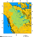
Mackenzie River drainage basin showing Great Slave Lake's position in the Western Canadian Arctic
-
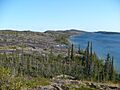
Eastern arm of Great Slave Lake.
-
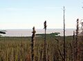
Northern Bay, Great Slave Lake
-
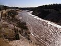
Hay River, one of the tributaries of Great Slave Lake


See also
 In Spanish: Gran Lago del Esclavo para niños
