
Mackenzie River facts for kids
Quick facts for kids Mackenzie River |
|
|---|---|

The Mackenzie River in August 2009
|
|

Map of the Mackenzie River watershed
|
|
| Other name(s) | French: Le fleuve Mackenzie, Slavey: Deh-Cho, Gwich'in: Nagwichoonjik, Inuvialuktun: Kuukpak, Michif: Grande Rivière |
| Country | Canada |
| Territories | |
| Cities | |
| Physical characteristics | |
| Main source | Great Slave Lake Fort Providence 156 m (512 ft) 61°12′15″N 117°22′31″W / 61.20417°N 117.37528°W |
| 2nd source | Most distant source of the Mackenzie–Slave–Peace–Finlay–Thutade system Headwater of Thutade Creek: a glacier snout on the south-west slopes of Alma Peak. 1,990 m (6,530 ft) 56°44′53″N 127°30′38″W / 56.74806°N 127.51056°W |
| River mouth | Arctic Ocean Beaufort Sea, Inuvik Region 0 m (0 ft) 68°56′23″N 136°10′22″W / 68.93972°N 136.17278°W |
| Length | 4,241 km (2,635 mi) |
| Width |
|
| Depth |
|
| Discharge (location 2) |
(Period of data: 1940-2017)288 km3/a (9,100 m3/s)
|
| Discharge (location 3) |
|
| Basin features | |
| Basin size | 1,783,912 km2 (688,772 sq mi) to 1,805,200 km2 (697,000 sq mi) |
| Tributaries |
|
The Mackenzie River is a huge river in Canada. It flows through forests and tundra in the Northwest Territories. This river system is the longest in Canada. It is also the second largest in North America, after the Mississippi River.
The Mackenzie River is 1,738 kilometres (1,080 mi) long. It starts from Great Slave Lake and flows north into the Arctic Ocean. There, it forms a big delta. The entire river system, including its many smaller rivers, is 4,241 kilometres (2,635 mi) long. This makes it one of the longest river systems on Earth.
The river's journey begins far away at Thutade Lake in British Columbia. For thousands of years, Indigenous peoples like the Inuvialuit and Gwich'in have lived along the Mackenzie. It was also a key route for early European explorers.
Today, the Mackenzie River region has some economic activities. These include fur trading in the past and oil discovery in the 1920s. Minerals like gold and zinc are found here. The river's waters are also used to create hydroelectricity.
Contents
Exploring the Mackenzie River's Path
Where the River Begins: Headwaters
The Mackenzie River system gathers water from many places. These include parts of British Columbia, Alberta, Saskatchewan, Yukon, and the Northwest Territories. The farthest source is Thutade Lake in British Columbia. Water from this lake flows into the Finlay and then the Peace River.
The Peace River and the Athabasca River are two major rivers that feed the Mackenzie. They collect water from the Rocky Mountains and the prairies of Alberta. These rivers meet at the Peace-Athabasca Delta. This is a large wetland area near Lake Athabasca.
From there, the Slave River forms and flows north into Great Slave Lake. The Slave River brings most of the water into Great Slave Lake. Other rivers like the Taltson and Hay River also flow into this lake.
The Main Journey: Mackenzie's Flow
The Mackenzie River itself starts from the western end of Great Slave Lake. This is about 150 kilometres (93 mi) southwest of Yellowknife. At first, the river is very wide. It then narrows near Fort Providence.
In 2012, the Deh Cho Bridge was built near Fort Providence. This bridge provides a safe way to cross the river. It is the only bridge over the main part of the Mackenzie. Further west, the river widens again, looking more like a shallow lake.

The river then turns northwest, passing Jean Marie River. At Fort Simpson, the Liard River joins it. The Liard River brings a lot of mud, which mixes with the clearer Mackenzie water. This creates a cool effect where one side of the river looks muddy and the other clear for a long distance.

The Mackenzie continues north through open forests. The Mackenzie Mountains are on its west side. Many smaller rivers join it from the west. The Great Bear River, which flows from Great Bear Lake, joins the Mackenzie at Tulita.
The river becomes very wide near Norman Wells. This area is important for oil production. Further north, the Mackenzie flows through a narrow limestone gorge called The Ramparts. This gorge is only 500 metres (1,600 ft) wide and up to 45 metres (148 ft) deep.
After passing Fort Good Hope, the Mackenzie crosses the Arctic Circle. It then becomes a braided river with many channels. The Arctic Red River joins it at Tsiigehtchic. Here, the Dempster Highway crosses the river using a ferry or an ice bridge in winter.
About 30 kilometres (19 mi) northwest of Tsiigehtchic, the river forms the huge Mackenzie River Delta. This delta has many channels, ponds, and wetlands. It covers over 12,000 square kilometres (4,600 sq mi) and is the second biggest Arctic delta in the world. The delta has many pingos, which are hills of earth-covered ice.
The Mackenzie River's Vast Drainage Basin
The Mackenzie River's drainage basin is the area of land where all water flows into the river. It covers almost 20 percent of Canada, about 1,805,000 square kilometres (697,000 sq mi). Most of this area has permafrost, which is ground that stays frozen all year.
The Mackenzie basin is surrounded by other major river systems. To the west, it borders the Yukon River and rivers flowing to the Pacific Ocean. To the east, it borders rivers flowing into Hudson Bay.
This basin is home to some of North America's largest lakes. Great Bear Lake is the biggest in the watershed. Great Slave Lake is slightly smaller but very deep. Lake Athabasca is another important lake in the system. There are also six other large lakes, including Williston Lake, a huge artificial lake.
How the Mackenzie River Flows: Water Characteristics
The Mackenzie River releases over 325 cubic kilometres (78 cu mi) of water each year into the Arctic Ocean. This is about 11% of all river water flowing into the Arctic. The river is frozen for most of the year. Ice usually breaks up in May or June. It freezes again in late October or November.

The average flow rate at its mouth is 9,910 m3/s (350,000 cu ft/s). This makes it the second largest river in Canada by flow. About 60 percent of its water comes from the western part of the basin. This includes water from the Rocky Mountains and other mountain ranges.
The large lakes in the eastern part of the basin help regulate the river's flow. They slow down the release of water during spring floods. This helps prevent extreme flooding downstream.
How the Mackenzie River Was Formed: Geology
About 30,000 years ago, a massive ice sheet covered most of northern Canada. This ice sheet, called the Laurentide Ice Sheet, was thousands of meters thick. When it melted, it left behind a huge lake called Lake McConnell. Today, Great Bear Lake, Great Slave Lake, and Lake Athabasca are what's left of this ancient lake.
The Mackenzie River channel itself is quite new in geological terms. It formed over a few thousand years as the ice sheet retreated. Before the ice ages, rivers in this area flowed differently. The Mackenzie system was "captured" by lower elevations to the northwest after the ice melted. This created its current path to the Arctic.
Around 13,000 years ago, huge floods from Lake Agassiz likely carved out parts of the Mackenzie channel. Lake Agassiz was a massive lake formed by melting ice. These floods might have even changed ocean currents and caused a cold period called the Younger Dryas.
The Mackenzie River carries a lot of sediment (like sand and mud). It transports about 128 million tonnes each year to its delta. Most of this sediment comes from rivers joining the Mackenzie downstream of Great Slave Lake.
Life Along the Mackenzie River: Ecology

The Mackenzie River's watershed is one of the largest natural areas in North America. About 63% of the basin is covered by boreal forest. Wetlands make up about 18% of the area. Most of these forests are untouched old-growth forest.
However, human activities like oil extraction can affect water quality. Also, a warming climate is melting permafrost in the northern parts of the watershed. This can make the soil unstable.
The forests mostly have black spruce, aspen, and poplar trees. In the north, you'll find smaller plants like dwarf birch and willows. There are also large areas of muskeg and peat bogs. Further south, there are more diverse forests, prairies, and fertile riverbanks.
There are 53 types of fish in the basin. The Mackenzie River has similar fish to the Mississippi River. Scientists believe these two river systems were connected during the Ice Ages. This allowed fish to move between them. Common fish include northern pike and lake whitefish.
Many migratory birds use the Mackenzie Delta and other deltas in the basin. These areas are important for resting and breeding. Over 215 bird species have been seen here. These include the whooping crane and bald eagle. However, changes to water levels from dams have affected bird populations.
Water mammals like beavers and muskrats are very common in the Mackenzie Delta. The Mackenzie estuary is also a place where beluga whales give birth.
A Journey Through Time: History of the Mackenzie River

Many people believe that early humans traveled through the Mackenzie valley. This happened over 10,000 years ago during their migration from Asia to North America. However, finding old human sites is hard because of floods and erosion. Indigenous peoples have lived along the river for thousands of years. The oldest known continuous settlement is at Tsiigehtchic, dating back about 1300–1400 years.
European explorers began using the Mackenzie as a route in the late 1700s. Scottish explorer Alexander Mackenzie traveled the river in 1789. He hoped it would lead to the Pacific Ocean. Instead, he reached the Arctic Ocean and the river was later named after him.

In the 19th century, the North West Company set up forts along the river. These became towns like Fort Simpson. The area was rich in beaver and muskrat, leading to a busy fur trade. Indigenous people were the first trappers. Later, more European trappers arrived, which led to a decrease in animal populations.
In the late 1800s and early 1900s, European diseases spread among Indigenous communities. This caused many people to lose their lives. For example, a severe influenza in 1928 affected many people along the river.
Steamboat service started in the 1880s. More boats appeared during the Klondike Gold Rush in the early 1900s. Steamboats carried people and goods along the river. They were a main way to travel into the northern interior.
Oil was found at Norman Wells in the 1920s. This started a period of industrial growth in the Mackenzie valley. Oil was shipped by steamboats to mines and towns. During World War II, oil from Norman Wells was sent to Fairbanks, Alaska, through the Canol pipeline. This pipeline was very expensive and had problems. It only operated for 13 months.
In 1964, the Mackenzie Northern Railway reached Great Slave Lake. This helped transport zinc from the Pine Point Mine. Even though the mine closed in 1988, the railway is still important for transportation.
In 1997, a special area along the Mackenzie River at Tsiigehtchic became a National Historic Site. It is important for the Gwichya Gwich'in culture and spirituality.
In 2008, researchers found a way to extract natural gas from methane hydrate in the Mackenzie Delta. This was an important step for future energy sources.
How People Use the Mackenzie River Today
.jpg)
In 2001, about 400,000 people lived in the Mackenzie River basin. Most of them lived in the southern parts, especially in Alberta. The cold northern areas are home mainly to Indigenous communities. Most of the Mackenzie watershed is wild. Human activities have little effect on the overall water quality.
Natural Resources and Economic Activities
The Mackenzie basin is rich in natural resources. There is oil and gas in the Northwest Territories and Alberta. Lumber is found in the Peace River headwaters. Uranium is in Saskatchewan, and gold and zinc are near Great Slave Lake. In 2003, there were gold mines near Yellowknife.
Communities along the river rely on fishing for food. There is also some commercial fishing. Farming is mostly in the Peace and Athabasca valleys. This area has very fertile soil. Warmer temperatures from climate change are expected to improve farming conditions.
An oil pipeline connects Norman Wells to Zama City, Alberta. New oil fields were found in the Mackenzie delta in the 1970s. In 2016, there were an estimated 166 billion barrels of oil in this region. There was a plan for a Mackenzie Valley Pipeline, but it was not built due to environmental concerns.
Traveling on the Mackenzie River: Transportation
When the river is not frozen, the Mackenzie is a key way to travel in northern Canada. It connects many isolated communities. Wide, calm parts of the river are often used by seaplanes. The northernmost major railhead (end of a railway line) is at Hay River. Goods are shipped there by train and then loaded onto barges.
Barges travel the entire length of the Mackenzie. They are pulled by tugboats in long "trains." Goods are shipped to Tuktoyaktuk on the Arctic coast. From there, they are transferred to larger ships. In winter, the frozen Mackenzie River becomes an ice road. This road is strong enough for large trucks.
Navigating the Mackenzie River can be tricky. Sandbars and shallow areas change every year. In some narrow parts, barges must be separated and towed one by one.
Harnessing Water Power: Hydroelectricity
There are no dams on the main Mackenzie River. However, many of its smaller rivers and sources have dams. These dams produce hydroelectricity, control floods, and help with irrigation. The W.A.C. Bennett Dam and Peace Canyon Dam on the upper Peace River were completed in 1968 and 1980. They produce a lot of electricity.
The reservoir behind the W.A.C. Bennett Dam, Williston Lake, is a huge artificial lake. It helps stabilize the water flow of the Peace, Slave, and Mackenzie rivers. This has made the Peace Valley better for farming. However, it has also affected wildlife and river communities.
The Site C Dam on the Peace River was completed in 2024. It generates enough power for many households. This project faced legal challenges from Indigenous groups and environmentalists.
Major Rivers Joining the Mackenzie: Tributaries
Largest Tributaries of the Mackenzie River
| Tributary | Length | Watershed | Discharge | |||
|---|---|---|---|---|---|---|
| km | mi | km2 | sq mi | m3/s | cu ft/s | |
| Liard River | 1,115 | 693 | 277,100 | 106,989 | 2,434 | 85,960 |
| North Nahanni River | 200 | 124 | ||||
| Root River | 220 | 138 | ||||
| Redstone River | 289 | 180 | 16,400 | 6,332 | 417 | 14,726 |
| Keele River | 410 | 255 | 19,000 | 7,340 | 600 | 21,200 |
| Great Bear River | 113 | 70 | 156,500 | 60,425 | 528 | 18,646 |
| Mountain River | 370 | 230 | 13,500 | 5,212 | 123 | 4,344 |
| Arctic Red River | 500 | 311 | 22,000 | 8,494 | 161 | 5,690 |
| Peel River | 580 | 360 | 28,400 | 10,965 | 689 | 24,332 |
Images for kids
-
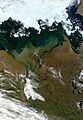
Satellite view of the lower Mackenzie River

See also
 In Spanish: Río Mackenzie para niños
- List of rivers of Canada
- List of rivers of the Northwest Territories
- Peace River Country
- Steamboats of the Mackenzie River
- Peel Watershed
