
Peace River (Canada) facts for kids
Quick facts for kids Peace River |
|
|---|---|

Peace River Valley in BC
|
|

Map of the Peace River watershed in western Canada
|
|
| Native name | Rivière de la Paix |
| Country | Canada |
| Province | British Columbia, Alberta |
| Cities | Fort Saint John, British Columbia, Peace River, Alberta |
| Physical characteristics | |
| Main source | Finlay River Thutade Lake, British Columbia 1,140 m (3,740 ft) 57°04′29″N 126°53′36″W / 57.07472°N 126.89333°W |
| 2nd source | Parsnip River Near Mount Barton, British Columbia 1,716 m (5,630 ft) 54°30′02″N 121°26′26″W / 54.50056°N 121.44056°W |
| River mouth | Slave River Confluence of Peace with Athabasca River, Alberta 59°00′01″N 111°24′38″W / 59.00028°N 111.41056°W |
| Length | 1,923 km (1,195 mi) |
| Basin features | |
| River system | Mackenzie River watershed |
| Basin size | 306,000 km2 (118,000 sq mi) |
| Tributaries |
|
The Peace River (which means rivière de la Paix in French) is a very long river in Canada. It stretches for about 1,923-kilometre-long (1,195 mi)! This amazing river starts high up in the Rocky Mountains in northern British Columbia. From there, it flows towards the northeast, making its way through northern Alberta.
The Peace River eventually joins another big river called the Athabasca River. They meet in a special area known as the Peace–Athabasca Delta. Together, they form the Slave River, which then flows into the even larger Mackenzie River. The Finlay River is considered the very beginning of the Peace River. It is also seen as the ultimate source of the entire Mackenzie River system. This combined Finlay–Peace–Slave–Mackenzie river system is one of the longest in the world, ranking as the 13th longest!
Contents
Where the Peace River Flows
The Peace River begins its journey in the mountains of British Columbia. Its main starting points are the Finlay River and the Parsnip River. These two rivers meet to form Williston Lake, which is a large reservoir. After leaving Williston Lake, the Peace River flows through beautiful valleys and plains.
Cities Along the River
As the Peace River travels, it passes by several important towns and cities. In British Columbia, it flows near Fort Saint John. In Alberta, it goes through the town of Peace River, Alberta. These communities often rely on the river for various activities and transportation.
The Name of the River
The name "Peace River" comes from a significant historical event. In 1781, a treaty was signed at a place called Peace Point, Alberta. This treaty helped to set the boundary between two Indigenous groups, the Beaver people and the Cree people. The river became a symbol of peace between them.
Images for kids
-
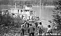
The Grenfell was one of the vessels that shipped cargo on the Peace River.
-
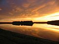
Peace River in Fort Vermilion, Alberta.
-
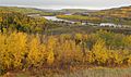
The Peace River as it winds past the town of Peace River during the autumntime.


See also
 In Spanish: Río de la Paz (Canadá) para niños
