
Peace River, Alberta facts for kids
Quick facts for kids
Peace River
Peace River Crossing (1898–1916)
Rivière-la-Paix (French) |
||
|---|---|---|
|
Town
|
||
| Town of Peace River | ||

Peace River seen from the Sagitawa Lookout
|
||
|
||

Location in the MD of Peace No. 135
|
||

Peace River
Location in Alberta

Peace River
Location in Canada
|
||
| Country | Canada | |
| Province | Alberta | |
| Region Sub-region |
Northern Alberta | |
| Planning region | Upper Peace | |
| Adjacent municipal districts | Municipal District of Peace No. 135, County of Northern Lights and Northern Sunrise County | |
| Incorporated | ||
| • Village | 2 June 1914 (as Peace River Crossing) | |
| • Name change | 22 May 1916 | |
| • Town | 1 December 1919 | |
| Area
(2021)
|
||
| • Land | 25.34 km2 (9.78 sq mi) | |
| Elevation | 330 m (1,080 ft) | |
| Population
(2021)
|
||
| • Total | 6,619 | |
| • Density | 261.2/km2 (677/sq mi) | |
| Time zone | UTC−07:00 (MST) | |
| • Summer (DST) | UTC−06:00 (MDT) | |
| Forward sortation area |
T8S
|
|
| Area code(s) | +1-780, +1-587, +1-825 | |
| Highways |
|
|
| Waterways |
|
|

Peace River is a town in northwest Alberta, Canada. It sits where the Peace River meets the Smoky River, Heart River, and Pat's Creek. It's about 486 km (302 mi) northwest of Edmonton. The town was first called Peace River Crossing between 1914 and 1916.
The town of Peace River is almost 300 meters (1,000 ft) below the flat land around it. Pat's Creek used to flow openly through town. Now, it runs through a culvert under the streets. It comes out at the Peace River in Riverfront Park.
In 2021, Peace River had a population of 6,619 people. Many people also live in nearby areas along Highway 2 and other roads. There are First Nation communities to the northeast. You can also find French-Canadian farming communities to the south and east. Mennonite and Hutterite German-Canadian farming communities are to the north and northwest.
Peace River hosted the Alberta Winter Games in 2004. In 2010, Peace River and Grimshaw together hosted the Alberta Summer Games.
Contents
History of Peace River
After the last ice sheets melted in northern Canada, people from Asia traveled through an ice-free path into the Americas. When the Ice Age ended, many groups moved north. They followed large herds of grazing animals. In the Peace River area, the main language groups were the Athapaskan and the Algonquian.
In 1670, the Hudson's Bay Company arrived in Eastern Canada. Guns became trade goods and moved westward. The Algonquian-speaking Cree pushed the Athapaskan-speaking Dunne-za (or Beaver) further west. The Beaver then pushed the Sekani into the Rocky Mountain Trench in the mid-1700s. The Cree and Beaver eventually made a truce. The big river they called Unchagah (the Peace River) became the border between their hunting lands.
The North West Company moved west in the late 1700s. They wanted to reach the Pacific Ocean. This caused a rivalry with the Hudson's Bay Company, another big fur-trading company.
Important Dates
- 1792: Alexander MacKenzie built Fort Fork on the east bank of the Peace River. It was just south of where it meets the Smoky River.
- 1818: The Hudson's Bay Company (HBC) opened the first Fort St. Mary's. It was at the meeting point of the Peace and Smoky rivers. It only lasted one season.
- 1820: The HBC built Fort St. Mary's III on the west side of the Peace River. It was right across from the mouth of the Heart River. This is where Peace River town is today.
- 1886: The Anglican Church started the first mission on Shaftesbury Trail.
- 1888: The Roman Catholic Church started the St. Augustine mission on Shaftesbury Trail.
- 1898: The North-West Mounted Police set up a permanent post at Peace River Crossing.
- 1909: The town area of Peace River was first mapped out.
- 1914: Peace River Landing Settlement became the Village of Peace River Crossing on June 2.
- 1914: Peace River's first hospital, the Irene Cottage Hospital, opened.
- 1910-1916: The railway reached the area. Settlers began moving into the valley.
- 1916: The Village of Peace River Crossing was renamed the Village of Peace River on May 22.
- 1919: The Village of Peace River became the Town of Peace River on December 1.
- 1926-1931: The population kept growing as the Great Depression affected Saskatchewan and Southern Alberta.
Historic Buildings and Sites

The Northern Alberta Railway (NAR) station was built in 1916. It was a busy place for passengers from 1916 to 1956. It was used for freight until 1981. The station had a fire in 1986. It was fixed up in 1991, costing about $300,000. Today, it is the Tourist Information Centre in Peace River.
The NAR station was used for passengers again in 2006. Alberta Prairie Steam Tours brought eight passenger cars to Peace River. People could travel like pioneers from the 1920s.

The Catholic St. Augustine Mission was set up in 1888. It is along Shaftesbury Trail. Missionaries came here to teach and help the First Nations people. An old cemetery is next to the mission. This site is now inside the Peace River Provincial Correctional Centre.
Third Mission Heritage Suites used to be the priests’ house. It was moved to Peace River in 1958. It became apartments before being made into a hotel suite.
The Anglican Mission Site was started in 1886. Only a small cemetery remains there now.
The St. James Anglican Cathedral Church was built in 1936. The church also built Athabasca Hall nearby. This hall was the biggest building in town. In 1979, the church sold it to the Town of Peace River.

The McNamara Hotel was built in 1921. It has burned down twice, in 1926 and 1993. It was rebuilt both times.
Fort Fork is a national historic site. It is in the Peace River Wildland Provincial Park. The fort was built in 1792. Alexander Mackenzie and David Thompson stayed there in the winters of 1792 and 1802. The fort was left in 1805. The Peace River has almost washed it away. Only a flag marks its old spot.

A 3.7 meter (12 ft) tall wooden statue stands at Riverfront Park. It honors Henry Fuller Davis, a famous person in Peace River's history. He was called “Twelve-Foot Davis” because he claimed a 3.7 meter (12 ft) piece of land during the Cariboo Gold Rush in British Columbia. He found almost $30,000 worth of gold there. He used this money to start a trading post near Peace River. That's why Peace River is sometimes called the Land of Twelve-Foot Davis. His grave is on top of Grouard Hill, east of town.
Dr. Greene Cairn is in Greene Valley Provincial Park. It remembers Dr. William Greene. He was a doctor and dentist. He was also one of the first eight men to fly in 1910.
Geography of Peace River

Peace River is in an area called the Peace River Formation. This area formed on the bottom of an old lake called Glacial Lake Peace. This lake covered most of the region below 610 meters (2,000 ft).
The town is in the Peace River Lowland. The Peace River and its smaller rivers cut through the old lake sediments and into the rock below. The Peace River Lowlands are surrounded by hills.

The area is mostly aspen parkland with mixed forests. There are many wet areas like marshes. These wetlands are used by different water birds for nesting. The parkland also has many land and water animals. This is also Canada's most northern farming area.
The Greene Valley Provincial Park is just east of town. The Peace River Wildland Provincial Park is to the south. These parks and the river valley are home to animals like moose, deer, bears, and many birds and fish. Keeping these natural areas safe helps protect wildlife.
Historically, the town has had floods. But now, the town has a system of dikes. These dikes protect against floods and ice-jam floods. This has greatly reduced the risk of flooding.
On November 30, 2022, a series of small earthquakes happened southeast of Peace River. One was a 5.59-magnitude earthquake. Researchers think it was caused by human activities linked to the local gas and oil industry. No damage or injuries were reported.
Climate of Peace River

Peace River has a humid continental climate. It has low rainfall all year. The climate is dry, so there is less humidity.
Air from the Pacific Ocean loses its moisture over the mountains before reaching Peace River. Cold air from the Arctic flows directly into the region. Because of cold air, the river valley often fills with fog. Outside the valley, the sky is clear. The fog usually clears in a few hours. Winds in town follow the Peace River valley. Outside the valley, winds can change a lot.
In winter, the Peace River often freezes from January to April. The ice cover is rough and uneven. The ice causes the river water levels in town to rise. This is watched by Alberta Environment and BC Hydro. BC Hydro runs two dams on the Peace River in British Columbia. These dams affect the river's water levels.
Summers often have thunderstorms. These storms sometimes bring small hail. Tornadoes are rare in the Peace River area.
Because Peace River is so far north, summer has long days. On June 21, there are 17 hours and 41 minutes of daylight. In winter, on December 21, there are less than seven hours of daylight. Peace River usually has sunny skies when it's daylight. There are about 2,060 hours of sunshine each year.
The temperature in the Peace River valley can be up to 5°C (9°F) warmer than the land around it. This special climate helps vegetables grow well in the valley.
The hottest temperature ever recorded in Peace River was 38.9°C (102.0°F) on July 4, 1926. The coldest was -56.7°C (-70.1°F) on January 12, 1911.
| Climate data for Peace River Airport, 1981–2010 normals, extremes 1907–present | |||||||||||||
|---|---|---|---|---|---|---|---|---|---|---|---|---|---|
| Month | Jan | Feb | Mar | Apr | May | Jun | Jul | Aug | Sep | Oct | Nov | Dec | Year |
| Record high °C (°F) | 12.1 (53.8) |
12.8 (55.0) |
20.6 (69.1) |
29.4 (84.9) |
36.7 (98.1) |
38.7 (101.7) |
38.9 (102.0) |
36.7 (98.1) |
34.4 (93.9) |
28.3 (82.9) |
20.0 (68.0) |
15.6 (60.1) |
38.9 (102.0) |
| Mean daily maximum °C (°F) | −9.9 (14.2) |
−6.4 (20.5) |
0.0 (32.0) |
9.8 (49.6) |
16.6 (61.9) |
20.5 (68.9) |
22.6 (72.7) |
21.5 (70.7) |
15.9 (60.6) |
8.2 (46.8) |
−3.3 (26.1) |
−7.7 (18.1) |
7.3 (45.1) |
| Daily mean °C (°F) | −14.9 (5.2) |
−11.9 (10.6) |
−5.6 (21.9) |
3.8 (38.8) |
10.0 (50.0) |
14.3 (57.7) |
16.3 (61.3) |
14.9 (58.8) |
9.6 (49.3) |
2.8 (37.0) |
−7.8 (18.0) |
−12.7 (9.1) |
1.6 (34.9) |
| Mean daily minimum °C (°F) | −19.9 (−3.8) |
−17.4 (0.7) |
−11.3 (11.7) |
−2.3 (27.9) |
3.3 (37.9) |
8.1 (46.6) |
10.0 (50.0) |
8.3 (46.9) |
3.2 (37.8) |
−2.7 (27.1) |
−12.3 (9.9) |
−17.8 (0.0) |
−4.2 (24.4) |
| Record low °C (°F) | −56.7 (−70.1) |
−48.9 (−56.0) |
−42.2 (−44.0) |
−38.9 (−38.0) |
−11.4 (11.5) |
−4.4 (24.1) |
−1.1 (30.0) |
−3.7 (25.3) |
−15.6 (3.9) |
−30 (−22) |
−42.2 (−44.0) |
−53.9 (−65.0) |
−56.7 (−70.1) |
| Average precipitation mm (inches) | 21.6 (0.85) |
14.2 (0.56) |
15.3 (0.60) |
18.1 (0.71) |
40.2 (1.58) |
66.4 (2.61) |
63.4 (2.50) |
45.4 (1.79) |
39.2 (1.54) |
23.5 (0.93) |
21.7 (0.85) |
17.4 (0.69) |
386.3 (15.21) |
| Average rainfall mm (inches) | 0.8 (0.03) |
0.5 (0.02) |
1.1 (0.04) |
10.1 (0.40) |
37.3 (1.47) |
66.4 (2.61) |
63.4 (2.50) |
45.4 (1.79) |
38.0 (1.50) |
13.3 (0.52) |
3.7 (0.15) |
0.7 (0.03) |
280.7 (11.05) |
| Average snowfall cm (inches) | 22.7 (8.9) |
15.7 (6.2) |
16.6 (6.5) |
8.8 (3.5) |
2.9 (1.1) |
0.0 (0.0) |
0.0 (0.0) |
0.0 (0.0) |
1.5 (0.6) |
10.7 (4.2) |
21.1 (8.3) |
18.6 (7.3) |
118.5 (46.7) |
| Average precipitation days (≥ 0.2 mm) | 10.6 | 8.3 | 8.2 | 6.9 | 10.2 | 11.7 | 13.6 | 11.1 | 10.3 | 9.6 | 11.4 | 9.9 | 121.7 |
| Average rainy days (≥ 0.2 mm) | 0.78 | 0.56 | 1.0 | 4.4 | 9.4 | 11.7 | 13.6 | 11.1 | 9.9 | 6.7 | 2.4 | 0.58 | 72.0 |
| Average snowy days (≥ 0.2 cm) | 10.3 | 8.0 | 7.6 | 3.2 | 1.2 | 0.0 | 0.0 | 0.0 | 0.67 | 4.2 | 10.0 | 9.4 | 54.5 |
| Source: Environment Canada | |||||||||||||
Urban Planning and Growth

Peace River is surrounded by other areas like the M.D. of Peace No. 135 and Northern Sunrise County. These areas work together to plan for Peace River's future growth. They want to share costs for services and taxes. This helps the town grow without having to take over more land.
The town wants to move industrial businesses away from the river. This will allow more homes to be built along the beautiful riverfront.
Peace River has a lower population density than some nearby towns. This is partly because of the hilly land in the river valley. The town plans to use its land wisely. This means building more homes in smaller areas. This helps use land and services efficiently. It also supports public transportation.
Downtown Improvements

In 2009, the town started a plan to improve its downtown and boost tourism. Key ideas included:
- Making the Riverfront District better with a marina and upgraded park.
- Opening Main Street to the Heart River with ramps and art.
- Creating a heritage park near the Tourist Information Centre.
- Building taller buildings (at least 3 stories) downtown.
- Improving the Twelve Foot Davis Ball Park for festivals. They also want to add a dance area for Aboriginal events.
Peace River Neighbourhoods

Peace River has different neighbourhoods. They are separated by hills and rivers.
The Downtown area is the main center for business, government, and culture. It has three parts:
- The Commercial District has offices, banks, shops, and restaurants.
- The Riverfront District is along the Peace River. It has restaurants, a mall, an arts hall, hotels, and parks.
- The Mixed Commercial/Residential District has homes, offices, and recreation spots.
The South End is the oldest neighbourhood. It is south of downtown, across the Heart River bridge. It has older homes and places for seniors.
The North End is north of Highway 2. It has two parts: Springfield and Norglen. This area has schools and most of the town's recreation centers. It also has many apartments.

West Peace is on the west side of the Peace River. It has Upper and Lower West Peace. These areas have mostly single-family homes.
The Pines neighbourhood is north of West Peace. It used to have many pine trees. Now it has single-family homes.
Rosedale is south of Lower West Peace. It has single-family homes on larger lots.
Shaftesbury Estates is south of Rosedale. It is growing fast and has single-family homes.

Saddleback Ridge is on West Hill, behind Misery Mountain. It has mostly single-family homes. Rolling Hills is a separate neighbourhood nearby.
Westbrook Estates is about 1 km (0.6 mi) south of Saddleback. It has homes on larger properties.
The West Hill Commercial District has big stores, hotels, and restaurants. The Northern Lakes College Peace River Campus is also here.
There are three trailer parks in Peace River: Cheviot Heights, Terrace, and Coolsprings. New residential areas are also being planned.
Population of Peace River
|
|||||||||||||||||||||||||||||||||||||||||||||||||||||||||||||||||||||
In 2021, the Town of Peace River had 6,619 people. This was a small decrease from 6,842 people in 2016. The town has a population density of 261.2 people per square kilometer (676.5 per sq mi).
In 2016, 6.3% of the people identified as First Nations. 11.0% identified as Métis.
In 2006, the average age in Peace River was 32.2 years. This was younger than Alberta's average of 36.0 years. Also, 7.4% of the population was under 5 years old. 8.2% were 65 or older.
Most residents (72.0%) identified as Christians in 2001. 26.5% had no religious affiliation.
Peace River has a strong Aboriginal culture. This is because of the area's history and nearby First Nation communities. The Peace River Aboriginal Inter-agency Committee organizes the Peace River Pow Wow. This event celebrates Aboriginal culture. It is held at the Peace River Agricultural Fair Grounds in June.
In 2006, 6.50% of residents spoke French as their first language. This is higher than the average for Alberta. The town is near French Canadian communities. St. Isidore, a French Canadian community nearby, hosts a Winter Carnival in February.
Economy of Peace River
The Government of Alberta is the biggest employer in Peace River. Many government offices are located here. After that, the main jobs are in resource industries. These include forestry, agriculture, oil, and gas. Over the years, Peace River's economy has grown. It now includes professional services, manufacturing, health care, and construction.
Peace River is close to the Peace River Oil Sands. This is Alberta's third-largest oil sands deposit. In 2010, Penn West Energy Trust made a big deal with China Investment Corporation. This deal helped fund oil sands operations. Shell also planned a large expansion in the area.
The Peace River is Alberta's largest river. But it has very few water permits. Less than 1% of its water flow is used. This is why large energy projects are being considered here. In 2008, Bruce Power wanted to build a nuclear power plant near Lac Cardinal. They later chose a different site north of town. However, in 2011, Bruce Power decided not to build a nuclear plant in Alberta.
Arts and Culture
Festivals and Events
Peace River has many annual festivals and events:
- St. Isidore Carnival in February
- Alberta Pond Hockey tournament in February
- African Heritage Month events in February
- Peace River Film Festival in March
- Aboriginal Gathering & Pow Wow in June
- Paddle the Peace on Father's Day
- Peace River Heritage Run in June
- Peace River Gold Cup jet boat racing in July
- Peace Fest in July
- Tri-River Triathlon in August
- Annual Peace River Gay Pride
Libraries
The Peace River Public Library is part of a big library system. This gives people access to over 2.9 million items across Alberta. The library has books, videos, music, and newspapers. It also has old environmental reports and a nuclear display.
The library is getting bigger and better. The new building will also have a cultural center and an art gallery.
There is a law library at the Peace River Courthouse. A toy library is at the Belle Centre. Other libraries are in nearby towns like Nampa and Grimshaw.
Film and Theatre
There are two theatre companies in the area. The Peace Players perform at Athabasca Hall in Peace River. The Lac Cardinal Regional Performing Arts Society performs in Grimshaw. Both groups put on several plays each year, including musicals and children's shows. They sometimes work together on bigger productions.
The Peace River Film Festival happens for two days in March at Athabasca Hall. Cinema 72 is a movie theatre with two screens. It mostly shows popular films. It is expanding to four screens to show more independent films. Cinema Politica also shows free documentaries twice a month. These films aim to start discussions about social and environmental issues.
Music and Visual Arts
Peace River has many musicians. No Limitz and Jeff McCann have performed across Canada. No Limitz hosts a music conference and songwriting workshop in May. They also organize free summer concerts at Riverfront Park. These concerts feature local musicians.
The North Peace Performing Arts Festival runs for almost two weeks in March. Students perform and can move on to provincial and national competitions.
PeaceFest is the biggest concert in the Peace River region. It started after a major flood in 1997. It happens in July at the Twelve Foot Davis Ball Park. It is held at the same time as jet boat racing and a fair.
The Peace River Art Club is a group of local artists. Their art is shown in various businesses, like Java Domain cafe. They also have exhibitions at Athabasca Hall and the Peace River Municipal Library.
Nightlife
Peace River has several nightclubs and pubs. The Underground Music Society also organizes blues, folk, and jazz concerts. These concerts happen on the last Saturday of certain months. The society is a non-profit group run by volunteers.
In 2008, Peace River created a bylaw for drinking establishments. This bylaw helps prevent violence. It requires businesses to provide first aid, clean up outside, and have good outdoor lighting.
Attractions
Museums
- Peace River Museum, Archives & Mackenzie Centre: This museum has over 10,000 items. It shows the history of fur trade, Aboriginal artifacts, and settlement in Peace River.
- Lac Cardinal Pioneer Village Museum: This museum shows what life was like in the 1920s and 1940s.
Other museums are in nearby towns like Nampa and Girouxville.
Parks and Trails

- Riverfront Park: Located south of downtown, this park has picnic tables, a playground, and a boat launch. It has an outdoor stage for performances. A giant wooden statue of Twelve Foot Davis is also here. Lights are put on the trees during Christmas.
- Peace River Lions Club Park: This park has campsites and trails. It is on the west side of the Peace River.
- 12 Foot Davis Grave Site and Dr. Greene Cairn Site: These sites are on Grouard Hill. They overlook the Smoky, Peace, and Heart Rivers.
- Normand Boucher Community Arboretum: This park has 140 trees and 42 shrubs. Many are different species from Alberta and around the world.
- Pat's Creek hiking trail: This 3 km (1.9 mi) trail is north of town. It used to be an old highway route. Cross-country skiing is popular here in winter.
Parks near Peace River include Wilderness Park and Queen Elizabeth Provincial Park. There is also a large trail system for walking and biking. This includes the dikes in the river valley. Part of the Trans Canada Trail runs through Peace River. The 29 km (18 mi) Friendship Trail connects Grimshaw and Peace River.
Recreation Facilities
Peace River has facilities for all seasons:
- Athabasca Hall: Built in 1938, this historic hall has 244 seats. It also has an art gallery and dance studio.
- Golf World on The Peace: This is an 18-hole mini-golf course. It is wheelchair accessible.
- Baytex Energy Centre: Opened in 1978, this arena can hold up to 1,900 people. It is home to hockey leagues.
- Peace Regional Pool: This pool opened in 1991. It has swimming lessons for all ages.
- Water Play Park: Peace River has an outdoor water park for kids. It is open in July and August.
- Misery Mountain skiing: On the West Hill, Misery Mountain has ski runs for all skill levels. It offers rentals, lessons, and a ski chalet.
- Golf courses: The area has several golf courses, including the 9-hole Creek Golf Course and the 18-hole Mighty Peace Golf Course.
Hunting and Fishing
The Peace River region has diverse wildlife. Hunters come for big game like moose, white-tailed deer, and elk. There are many companies that offer hunting trips. Ducks and geese are hunted at nearby Lac Cardinal. Black bears, coyotes, and wolves are also hunted.
There are many fishing spots in the region. The Peace River and its smaller rivers have fish like Arctic Grayling, Bull Trout, and Walleye. Some lakes are stocked with fish.
Tours and Adventures

- Northbase Outdoor Ranch: Offers outdoor events for all ages. This includes kids' camps, riding lessons, and horseback trail rides. You can also rent canoes to paddle on the Peace River.
- Peace Valley Guest Ranch: Offers river boat cruises on the Peace River and horse trail rides.
- Shaftesbury Ferry: You can ride across the river on this working ferry. It is about 25 km (16 mi) south of Peace River. The ferry runs during daylight hours and is free.
Sports and Recreation
Peace River has competitive sports like hockey, baseball, Tae Kwon Do, curling, soccer, and boxing. The Peace River Stampeders play in the North Peace Hockey League. The Peace River Navigators play in the Northwest Junior Hockey League. Youth hockey programs are also available.
The area has baseball, fastball, and slow pitch leagues. Many curling events are held in winter. Tae Kwon Do and boxing clubs host tournaments. Golf courses also host many tournaments.
| Club | League | Sport | Venue | Established | Championships |
|---|---|---|---|---|---|
| North Peace Navigators | NWJHL | Ice Hockey | Baytex Energy Centre | 2000 | 3 |
High-profile sports include the Alberta Pond Hockey Championships at Lac Cardinal. Winners can go to the World Pond Hockey Championships. Jet boat racing for the Peace River Gold Cup is also popular. The Tri-River Triathlon is a competitive event.
Peace River schools have done well in swimming, volleyball, basketball, badminton, and track and field. High school football has become strong. The Peace River Pioneers football team reached the provincial finals in 2009 and 2010. They have won four Mighty Peace Football League championships.
Many recreational leagues are available for all ages and skill levels. These include tennis, soccer, squash, volleyball, softball, curling, basketball, and ice hockey.
The Peace Country Fish & Game Association has a shooting range. It hosts competitive and recreational events.
Summer activities include boating, tubing, hiking, biking, and photography. In winter, people enjoy tobogganing, snowmobiling, and skiing at Misery Mountain. There is also drop-in basketball. At the end of ski season, Misery Mountain hosts the Slush Cup. Skiers try to cross an icy pond.
Infrastructure
Transportation
Peace River is on Highway 2, which goes to southern Alberta. It is also near Highway 35 to the Northwest Territories and Highway 43 to British Columbia and Alaska. This makes it an important link for travel. These highways also provide access to oil, gas, and forest areas.
The old Northern Alberta Railway tracks provide the only rail crossing over the Peace River in Alberta. The Canadian government built the Great Slave Lake Railway. It runs north from Peace River to Hay River, Northwest Territories. This is Canada's most northern railroad. It was built to help ship lead-zinc ore. Now, Canadian National Railway owns and runs the line.
Road Network
Peace River's roads are set up in a grid. Avenues run east to west, and streets run north to south. 100 Avenue and 100 Street are in the downtown area. Avenue numbers increase to the south, and street numbers decrease to the east. Some roads still have their old historical names.
Airport
The town owns and manages the Peace River Airport (IATA: YPE, ICAO: CYPE). It is 5 km (3.1 mi) west on Highway 2. Northern Air has regular flights to and from Edmonton. They also offer charter flights and air ambulance services.
A committee is looking into the airport's future. It includes representatives from Peace River and nearby areas.
Public Transit
Peace River used to have a small bus network called Peace River Transit. It was run by the town's Community Services Department. In 2006, 1.4% of people used public transit for work. The number of riders was growing. Special taxi passes were available for seniors, people with disabilities, and low-income individuals. The bus system stopped in 2011 due to high costs. However, the taxi pass program is still available.
It is hard for small towns to have good public transit. This is because people live far apart. This makes it harder for buses to serve everyone.
Utilities
Peace River gets its water from the Peace River. The water is treated at the Shaftesbury Water Treatment Plant. It is then pumped to three reservoirs. Wastewater is treated at a plant in the north end of town. Garbage collection is handled by a private company.
Providing water and sewer services in Peace River is challenging. This is due to big changes in temperature and elevation. This can cause leaks and breaks in pipes. The changing elevation also means many pump stations are needed. These factors make building and maintaining infrastructure expensive.
Education
Peace River has both public and Catholic schools. The Peace River School Division runs public schools like Springfield Elementary, T.A. Norris Middle School, and Peace River High School. The Holy Family Catholic Regional Division runs Catholic schools like Good Shepherd School and Glenmary Catholic Junior/Senior High School. The Conseil scolaire du Nord-Ouest No. 1 runs École des Quatre-Vents, a French public school. Peace River Adventist Junior Academy is another private school.
Northern Lakes College Peace River Campus offers post-secondary education. They have trades training in carpentry, electrical, and welding. The campus also hosts the Boreal Research Institute.
Peace Adult Literacy offers a volunteer program to help adults learn to read and write.
Media
The region has two weekly newspapers: the Peace River Record-Gazette and Mile Zero News. The Record-Gazette covers Peace River and nearby areas. Mile Zero News covers Grimshaw and other areas. They often report on similar news.
Peace River has two local radio stations: CKKX-FM (Kix FM) and CKYL-FM (River Country). Both are owned by Peace River Broadcasting. Other radio stations are also available in the area.
Notable People
- Wade Campbell
- Chrystia Freeland
- Linden Gaydosh
- Jillian Harris
- Kelly Kisio
- Melina Laboucan-Massimo
- Ken Lovsin
- Darren Kramer
- Chris Osgood
- Alex Ritson
- Brian Skrudland
- Aaron James Sorensen
- Fred Sutherland
- Nigel Whitmey
Images for kids
-
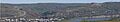
Peace River as seen from West Hill.
-
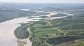
Aerial view of the Town of Peace River
-
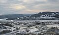
Peace River in winter


