Eastern Canada facts for kids
Quick facts for kids
Eastern Canada
Est du Canada (French)
|
|
|---|---|

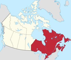
Eastern Canada (red) within the rest of Canada (tan)
|
|
| Country | Canada |
| Composition | |
| Principal cities | |
| Area | |
| • Total | 2,783,400 km2 (1,074,700 sq mi) |
| Population
(2016)
|
|
| • Total | 23,946,177 |
| • Density | 8.60321/km2 (22.2822/sq mi) |
Eastern Canada (also called the Eastern provinces or the East) is a large region in Canada. It is located south of Hudson Bay and east of the province of Manitoba. This area includes six different provinces.
These provinces are: Newfoundland and Labrador, Nova Scotia, Prince Edward Island, New Brunswick, Quebec, and Ontario. The two largest provinces, Ontario and Quebec, are often called Central Canada. The other four provinces are known as Atlantic Canada. New Brunswick, Nova Scotia, and Prince Edward Island are also known as the Maritime provinces.
Contents
Canada's Eastern Capitals
Canada's capital city, Ottawa, is found in Eastern Canada. It is located within the province of Ontario.
Each province in Eastern Canada also has its own capital city:
- Newfoundland and Labrador - St. John's
- Nova Scotia - Halifax
- Prince Edward Island - Charlottetown
- New Brunswick - Fredericton
- Quebec - Quebec City
- Ontario - Toronto
What Defines Eastern Canada?
Different groups sometimes define Eastern Canada in slightly different ways. For example, The Canadian Press news agency considers everything east of and including Thunder Bay, Ontario, to be part of Eastern Canada.
Eastern Canada's Population
In 2016, the total population of Eastern Canada was about 23,946,177 people. This means that about 70% of all Canadians live in this region! Most of these people live in the provinces of Ontario and Quebec.
This region is home to three of Canada's five biggest cities. Toronto, in Ontario, is one of the largest cities in all of North America.
Largest Cities in Eastern Canada
Here are some of the biggest metropolitan areas (cities and their surrounding areas) in Eastern Canada:
- Toronto, Ontario - 6,254,191 people
- Montreal, Quebec - 4,098,927 people
- National Capital Region (Ottawa-Gatineau, Ontario-Quebec) - 1,568,381 people
- Quebec City, Quebec - 807,200 people
- Hamilton, Ontario - 536,917 people
- London, Ontario - 474,786 people
- St. Catharines-Niagara, Ontario - 447,888 people
- Kitchener, Ontario - 441,380 people
- Halifax, Nova Scotia - 403,131 people
- Windsor, Ontario - 329,144 people
- Barrie, Ontario - 212,667 people
- Sherbrooke, Quebec - 212,105 people
- St. John's, Newfoundland and Labrador - 205,955 people
Population by Province
Here is how many people lived in each Eastern Canadian province in 2016, from the most to the least populated:
- Ontario - 13,448,494 people
- Quebec - 8,164,361 people
- Nova Scotia - 923,598 people
- New Brunswick - 747,101 people
- Newfoundland and Labrador - 519,716 people
- Prince Edward Island - 142,907 people
See also
 In Spanish: Este de Canadá para niños
 | Laphonza Butler |
 | Daisy Bates |
 | Elizabeth Piper Ensley |


