
Quebec City facts for kids
Quick facts for kids
Québec
|
|||||
|---|---|---|---|---|---|
| Ville de Québec (French) | |||||
|
|||||
| Nickname(s):
La Vieille Capitale
|
|||||
| Motto(s):
Don de Dieu feray valoir
("I shall put God's gift to good use"; the Don de Dieu was Champlain's ship) |
|||||

Québec
Location in Quebec

Québec
Location in Canada
|
|||||
| Country | Canada | ||||
| Province | Quebec | ||||
| Region | Capitale-Nationale | ||||
| Metropolitan community | Communauté métropolitaine de Québec | ||||
| Agglomeration | Agglomeration of Quebec City | ||||
| Historic countries | Kingdom of France Kingdom of Great Britain |
||||
| First settled | 11 October 1535, by Jacques Cartier |
||||
| Founded | 3 July 1608, by Samuel de Champlain |
||||
| Constituted | 1 January 2002 | ||||
| Incorporated | 1832 | ||||
| Boroughs |
List
Beauport
Charlesbourg La Cité-Limoilou La Haute-Saint-Charles Les Rivières Sainte-Foy–Sillery–Cap-Rouge |
||||
| Government | |||||
| • Type | Quebec City Council | ||||
| Area | |||||
| • City | 452.30 km2 (174.63 sq mi) | ||||
| • Land | 453.38 km2 (175.05 sq mi) | ||||
| • Urban | 442.85 km2 (170.99 sq mi) | ||||
| • Metro | 3,499.46 km2 (1,351.15 sq mi) | ||||
| Elevation | 98 m (322 ft) | ||||
| Population
(2021)
|
|||||
| • City | 549,459 (12th) | ||||
| • Density | 1,214.8/km2 (3,146/sq mi) | ||||
| • Urban | 733,156 (8th) | ||||
| • Urban density | 1,655.5/km2 (4,288/sq mi) | ||||
| • Metro | 839,311 (7th) | ||||
| • Metro density | 239.8/km2 (621/sq mi) | ||||
| • Pop 2016–2021 | |||||
| Demonym(s) | Québécois or Québécois de Québec (to distinguish residents of the city from those of the province) | ||||
| Time zone | UTC−05:00 (EST) | ||||
| • Summer (DST) | UTC−04:00 (EDT) | ||||
| Postal codes |
G1A to G2N
|
||||
| Area codes |
|
||||
| GDP (Québec CMA) | CA$47.94 billion (2020) | ||||
| GDP per capita (Québec CMA) | CA$53,477 (2016) | ||||
| Official name: Historic District of Old Quebec | |||||
| Type: | Cultural | ||||
| Criteria: | iv, vi | ||||
| Designated: | 1985 (9th session) | ||||
| Reference #: | 300 | ||||
| Region: | Europe and North America | ||||


Quebec City (also called Québec) is the capital city of the Canadian province of Quebec. In July 2021, about 549,459 people lived in the city. Its larger metropolitan area had a population of 839,311. This makes it the twelfth-largest city and seventh-largest metropolitan area in Canada. It is also the second-largest city in the province, after Montreal. Quebec City has a climate with warm summers and cold, snowy winters.
Samuel de Champlain, a French explorer, founded a French settlement here in 1608. He used the Algonquin name for the area. Quebec City is one of the oldest European settlements in North America. The walls around Old Quebec are the only fortified city walls left in the Americas north of Mexico. In 1985, UNESCO named this area a World Heritage Site.
Contents
- Understanding the Name of Quebec City
- Exploring the History of Quebec City
- Geography and Climate of Quebec City
- Boroughs and Neighbourhoods of Quebec City
- Who Lives in Quebec City?
- Economy of Quebec City
- Arts and Culture in Quebec City
- Attractions in Quebec City
- Sports in Quebec City
- Transportation in Quebec City
- Education in Quebec City
- Sister Cities of Quebec City
- Images for kids
- See also
Understanding the Name of Quebec City
The name "Quebec" comes from the Algonquin word Kébec. This word means "where the river narrows". The Saint Lawrence River becomes narrower near the promontory of Quebec and its Cape Diamant.
In English, people often say "Quebec City" to tell it apart from the province of "Quebec". Both the Canadian and Quebec governments officially spell the city's name with an accent: Québec. However, in English, the federal government spells the province name without an accent (Quebec).
Exploring the History of Quebec City
Quebec City is one of the oldest European settlements in North America. It is the only fortified city north of Mexico that still has its original walls.
Early French Settlements (1500s–1763)
The first known French settlement in North America was Fort Charlesbourg-Royal. Explorer Jacques Cartier started it in 1541 with about 400 people. But they left less than a year later because of the harsh winter and resistance from local Indigenous people.

Samuel de Champlain officially founded Quebec on July 3, 1608. He built it where an old St. Lawrence Iroquoian settlement called Stadacona used to be. Champlain is known as "The Father of New France".
The settlement was small for many years. In 1629, English privateers led by David Kirke captured it during a war. Champlain argued that this was illegal because the war had already ended. In 1632, the English king Charles I agreed to return the lands to France.
By 1665, about 550 people lived in 70 houses in the city. Many were members of religious groups. Quebec was a base for attacks against New England during the French and Indian Wars. In 1690, the English attacked the city but were defeated.
During the French and Indian War (also called the Seven Years' War), the British captured Quebec in 1759. This happened after the Battle of the Plains of Abraham. British troops led by General James Wolfe defeated the French under General Louis-Joseph de Montcalm.

France gave New France, including Quebec City, to Britain in 1763. This marked the end of French rule. At that time, Quebec was a town of 8,000 people. It was known for its grand buildings and fortifications.
British and Canadian Rule (1763–Present)
During the American Revolution, American troops attacked the British in Quebec City in 1775. They hoped the people of Quebec would join their fight for independence. However, the American invasion failed. Quebec remained under British control and later became part of Canada.

The city was not attacked during the War of 1812. But fears of another American attack led to the building of the Citadelle of Quebec starting in 1820. The Citadelle housed British soldiers until 1871 and is still used by the military today. It is also a popular tourist spot.
Until the late 1700s, Quebec City was the largest city in what is now Canada. In 1790, Montreal became larger. Quebec City remained the capital of Lower Canada. From 1841 to 1867, the capital of the Province of Canada moved between several cities, including Quebec City.

The city had a strong economy in the 1800s. This was thanks to its location on the Saint Lawrence River. Industries like wooden ship building and timber export thrived. However, by the 1870s, Quebec City's economy declined. New steel steamships and railroads reduced the need for its port. Many English-speaking people moved to Montreal.
The Quebec Conference on Canadian Confederation took place here in 1864. In 1867, Queen Victoria chose Ottawa as Canada's capital. Quebec City became the capital of the new province of Quebec.
During World War II, two important conferences were held in Quebec City. Leaders like Franklin D. Roosevelt (U.S. President) and Winston Churchill (U.K. Prime Minister) met here. They discussed plans for the war, including the D-Day landings. These meetings happened at the Citadelle and the Château Frontenac.

In 2002, many nearby towns joined Quebec City. This made the city much larger. In 2008, Quebec City celebrated its 400th anniversary. It received funds for celebrations and new projects.
Geography and Climate of Quebec City
Quebec City is on the north bank of the Saint Lawrence River. This is where the river narrows and meets the Saint-Charles River. Old Quebec sits on top and at the bottom of Cap Diamant. This is a high point on the eastern edge of a plateau.
.jpg)
Because of this, the oldest part of the city has an "upper town" and a "lower town". North of the hill, the land is flat and good for farming. The Laurentian Mountains are to the north, with some foothills inside the city limits.
The Plains of Abraham are on the plateau's southeastern side. High stone walls were built here long ago. The lower town areas like Saint-Roch and Saint-Sauveur are separated from the upper town by a wooded area.
What is the Climate Like in Quebec City?
Quebec City has four clear seasons. Summers are warm, sometimes hot, with high humidity. Winters are cold, windy, and snowy. Spring and fall are short, with cool to warm temperatures.

On average, Quebec City gets a lot of precipitation. About 899 mm is rain and 303 mm is melted snow. Snow usually stays on the ground from late November until mid-April. The city gets about 1,916 hours of sunshine each year.
The highest temperature ever recorded was 36.1°C on July 17, 1953. The coldest was -36.7°C on January 10, 1890, and January 14, 2015.
Boroughs and Neighbourhoods of Quebec City
On January 1, 2002, 12 towns joined Quebec City. These included Sainte-Foy, Beauport, and Charlesbourg. Some towns later became separate again, but most remain part of Quebec City.

Quebec City has six main areas called boroughs (arrondissements). These are divided into 35 neighbourhoods (quartiers). Many neighbourhoods keep the names of the old towns they replaced. Each neighbourhood elects its own council.
There isn't a huge difference in income between neighbourhoods. However, some areas are wealthier. These include the former cities of Sillery, Cap-Rouge, and Sainte-Foy.
The traditional working-class areas are in the lower town, like Saint-Sauveur and Saint-Roch. Areas like Limoilou and Saint-Roch have become more modern in recent years. They now attract young professionals and new businesses.
| Boroughs | Neighbourhoods |
| 1 La Cité-Limoilou | La Cité: 1-1 Vieux-Québec–Cap-Blanc–colline Parlementaire · 1-2 Saint-Roch · 1-3 Saint-Jean-Baptiste · 1-4 Montcalm · 1-5 Saint-Sauveur · 1-6 Saint-Sacrement · Limoilou: 6-1 Vieux-Limoilou · 6-2 Lairet · 6-3 Maizerets |
| 2 Les Rivières | 2-1 Neufchâtel-Est–Lebourgneuf · 2-2 Duberger-Les Saules · 2-3 Vanier |
| 3 Sainte-Foy–Sillery–Cap-Rouge | 3-1 Sillery · 3-2 Cité universitaire · 3-3 Saint-Louis · 3-4 Plateau · 3-5 Pointe-de-Ste-Foy 8-2 · L'Aéroport · 8-3 Cap-Rouge |
| 4 Charlesbourg | 4-1 Notre-Dame-des-Laurentides · 4-2 Quartier 4-2 · 4-3 Quartier 4-3 · 4-4 Jésuites, Quebec City · 4-5 Quartier 4-5 · 4-6 Quartier 4–6 |
| 5 Beauport | 5-1 Quartier 5-1 · 5-2 Quartier 5-2 · 5-3 Chutes-Montmorency · 5-4 Quartier 5-4 · 5-5 Vieux-Moulin |
| 7 La Haute-Saint-Charles | 7-1 Lac-Saint-Charles · 7-2 Saint-Émile · 7-3 Loretteville · 7-4 Des Châtels · 8-1 Val-Bélair |
Who Lives in Quebec City?
In 2021, the population of Quebec City was 549,459 people. This was a 3% increase from 2016. The average age in Quebec City is 43.3 years old.
Diversity in Quebec City
In 2021, about 9.4% of Quebec City residents were from visible minority groups. This is lower than the Canadian average of 26.5%. The largest visible minority group is Black Canadians, making up 4.1% of the population. About 1.8% of residents are Indigenous Canadians.
Languages Spoken in Quebec City
Most people in Quebec City speak French as their first language. In 2021, 90.6% of residents spoke only French at home. About one-third of the city's residents can speak both French and English. The number of people who speak English as their first language is about 1.5%.
Economy of Quebec City
Most jobs in Quebec City are in public administration, defense, services, trade, transport, and tourism. As the capital of the province, the government is the largest employer. It employed 27,900 people in 2007. The local hospital network, CHUQ, is the largest institutional employer.

About 10% of jobs are in manufacturing. Key products include paper, food, metal, chemicals, and electronics. Many important companies have their main offices in Quebec City. These include fashion retailer La Maison Simons and video game companies like Beenox and Ubisoft.
Business Areas in Quebec City
The main business areas are on Parliament Hill and in Saint-Roch. Saint-Roch is now known for its technology and video game companies. A newer business area has grown in Sainte-Foy, with many accounting and law firms.

Arts and Culture in Quebec City
Quebec City is famous for its Winter Carnival. This is the world's largest winter festival. It also hosts a popular summer music festival. People also celebrate Saint-Jean-Baptiste Day here.

The Parc Aquarium du Québec is a great place to visit. It has over 10,000 animals, including mammals, reptiles, and fish. You can see Polar bears and different types of seals. There's also a "Large Ocean" area where you can view aquatic life from below.
Quebec City has many historic sites, art galleries, and museums. These include the Citadelle of Quebec, the Musée national des beaux-arts du Québec, and the Musée de la civilisation.

Other fun places to visit are Montmorency Falls. Just outside the city, you can find the Basilica of Sainte-Anne-de-Beaupré, the Mont-Sainte-Anne ski resort, and the Ice Hotel.
Attractions in Quebec City
With its high cliffs and the Citadelle of Quebec overlooking the St. Lawrence River, Quebec City has been called the "Gibraltar of North America".
Architecture and Famous Buildings
Much of the city's old and beautiful architecture is in Vieux-Québec (Old Quebec). This area is inside and below the fortifications. It feels very European with its stone buildings and winding streets.

The main gates through the walls are Porte Saint-Louis and Porte Saint-Jean. The Kent Gate was a gift from Queen Victoria. West of the walls is Parliament Hill, and to the south are the Plains of Abraham.
The upper and lower parts of the city are connected by many stairs. One famous one is the Escalier « casse-cou » ("breakneck stairway"). You can also take the Old Quebec Funicular on the historic Rue du Petit-Champlain. This street has many small shops.

Nearby is Place Royale, a small town square. This is where Champlain founded the city in 1608. The Notre-Dame-des-Victoires church is there. The Musée de la Civilisation is also close by the river.
The city's skyline is dominated by the huge Château Frontenac hotel. It sits on top of Cap-Diamant. This hotel was designed to look like a castle. It was built to encourage luxury tourism.
.jpg)
Next to the Château Frontenac is the Terrasse Dufferin. This walkway along the cliff offers amazing views of the Saint Lawrence River. The terrace leads to the Plains of Abraham, where a famous battle took place. It also leads to the Citadelle of Quebec, a military base and a home for the Governor General of Canada. The Parliament Building is also nearby.
The Notre-Dame de Québec Cathedral is the main Catholic church in Quebec City. It was the first church in the New World to be called a basilica. Quebec City has 37 National Historic Sites of Canada.
Parks and Green Spaces
One of the most famous parks is The Battlefields Park. It has 50 historical cannons and the Plains of Abraham. The park offers views of the St. Lawrence River. It also has historical buildings and statues, like the Joan of Arc on Horseback. This park was the site of the Battle of the Plains of Abraham in 1759.
Other large parks include Parc Victoria and Parc Maizerets. Quebec City's largest park is the Parc Chauveau. The Saint-Charles River runs through it. You can go canoeing, fishing, and cross-country skiing there.
The Promenade Samuel-De Champlain is a beautiful path along the Saint Lawrence River. It stretches for 4.6 km. It has paths for biking and walking. This promenade was built to celebrate Quebec City's 400th anniversary in 2008.
Sports in Quebec City
Quebec City has hosted many sporting events. It was even considered for the 2002 Winter Olympics. The city co-hosted the 2008 IIHF World Championship in hockey.
Regular events include the Coupe Banque Nationale (a tennis tournament) and Crashed Ice (an extreme downhill skating race). The Quebec International Pee-Wee Hockey Tournament is a famous minor hockey event.

The city has one professional sports team, the baseball team Capitales de Québec. They play in the Frontier League at Stade Canac. They have won nine league titles.
Quebec City used to have a professional ice hockey team, the Quebec Nordiques. They played in the National Hockey League (NHL) until 1995. The team moved to Denver, Colorado, and became the Colorado Avalanche.

The Videotron Centre was built hoping to bring an NHL team back to Quebec City. It is also hoped that this arena will help Quebec City win a future Winter Olympics bid. It is now the main arena in the city.
Other teams include the Quebec Remparts in major junior hockey. Université Laval has its Rouge & Or varsity teams.
Transportation in Quebec City
Two bridges, the Quebec Bridge and Pierre Laporte Bridge, connect Quebec City to Lévis on the south side of the Saint Lawrence River. A ferry service also connects them. The Orleans Island Bridge links the city to Orleans Island.

Quebec City is a major hub for the province's autoroute (highway) system. Autoroute 40 connects the region to Montreal and Ottawa. Autoroute 20 runs along the south shore of the St. Lawrence River. Autoroute 73 links the city north to Saguenay and south to Maine.
Public Transportation
The Réseau de transport de la Capitale (RTC) manages public transport. They operate buses, including articulated buses. The RTC is also looking into bringing back a tramway system. This would help with crowded bus lines and encourage more people to use public transit.

Train services are run by Via Rail at the Gare du Palais (Palace Station). This station is the eastern end of the main railway line to Windsor. A bus station next to the train station offers long-distance bus services.
Air and Sea Travel
Jean Lesage International Airport serves Quebec City. It is about 13 km west of the city center. The Port of Quebec is a seaport on the St. Lawrence River.
Education in Quebec City

Université Laval (Laval University) is in the southwestern part of the city. Its architecture school is in Old Quebec. The Université du Québec system has its main offices and some special schools in the Saint-Roch neighbourhood.
Quebec City has several CEGEPs (colleges). These include Collège François-Xavier-Garneau, Cégep Limoilou, Cégep de Sainte-Foy, and Champlain College St. Lawrence. There are also private colleges.
Three school boards manage schools in Quebec City. The Commission scolaire de la Capitale runs French-speaking schools. The Central Quebec School Board runs the English-speaking schools.
Quebec City is home to the oldest educational institution for women in North America. It was founded by the Ursulines of Quebec and is now a private elementary school.
Sister Cities of Quebec City
Quebec City has "sister city" relationships with other cities around the world. These include:
It also has formal agreements with cities like Saint Petersburg in Russia and Paris, France.
Images for kids
-
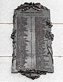
Plaque honoring the first settlers of Québec City.
-
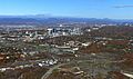
North-east aerial view from the Quebec Bridge area. The foreground shows the Sainte-Foy neighbourhood of Saint-Louis and the modern buildings of boulevard Laurier.
-
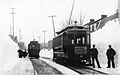
A tram in Quebec City in 1898
-
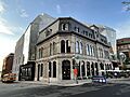
Le Diamant Theatre in Quebec City's Saint-Roch neighborhood
-
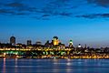
Québec, photographed from Lévis

.jpg)


See also
 In Spanish: Quebec (ciudad) para niños
