
Île d'Orléans facts for kids
|
Native name:
Île d'Orléans
|
|
|---|---|

Île d'Orléans' pastoral character is well preserved
|
|
| Lua error in Module:Location_map at line 416: Malformed coordinates value.
Location within Quebec
|
|
| Geography | |
| Coordinates | Lua error in Module:Coordinates at line 614: attempt to index field 'wikibase' (a nil value). |
| Adjacent bodies of water | Saint Lawrence River |
| Area | 192.85 km2 (74.46 sq mi) |
| Length | 34 km (21.1 mi) |
| Width | 8 km (5 mi) |
| Highest elevation | 150 m (490 ft) |
| Administration | |
|
Canada
|
|
| Province | Quebec |
| Regional county | L'Île-d'Orléans |
| Demographics | |
| Population | 7,082 (2016) |
| Pop. density | 37 /km2 (96 /sq mi) |
Île d'Orléans (which means Island of Orleans in English) is a lovely island in the Saint Lawrence River. It's located about 5 kilometers (3 miles) east of downtown Quebec City, Quebec, Canada. This island was one of the very first places in Quebec where the French settlers made their homes. Many French Canadians today can trace their family history back to the early people who lived on this island. It's often called a "miniature Quebec" because it shows what traditional Quebec life was like.
About 7,000 people live on the island, spread out among 6 small villages. You can reach the island from the mainland by crossing the Île d'Orléans Bridge from Beauport. Route 368 is the only main road on the island. It crosses the bridge and goes all the way around the island. In the village of Sainte-Pétronille, you can find a great spot to see the amazing Chute Montmorency (Montmorency Falls). You can also enjoy a wide view of the Saint Lawrence River and Quebec City from there.
Île d'Orléans is a twin island with Île de Ré in France. This means they share a special friendship and cultural connection.
Island Geography
The Island of Orleans sits between the Canadian Shield (a large rocky area) to the north and the Appalachian Mountains to the south. Its northeastern tip marks where the fresh water of the Saint Lawrence River starts to mix with salt water. This area is the beginning of the Saint Lawrence estuary, which is the largest in the world.
Two channels separate the island from the mainland. The Île d'Orléans Channel is to the northwest, and the Grands Voiliers Channel is to the southeast.
The island has an uneven shape with many coves and capes. It is about 34 kilometers (21 miles) long and 8 kilometers (5 miles) wide at its widest point. The island's total distance around is about 75 kilometers (47 miles), and its total area is 190 square kilometers (73 square miles). It has rolling hills, small valleys, and gentle slopes. The highest points reach about 150 meters (490 feet) in Sainte-Pétronille and Saint-Laurent.
Some of the main streams on Île d'Orléans include:
- Chenal des Grands Voiliers (on the southeast side)
- Chenal de l'Île d'Orléans (on the northwest side)
- Rivière Dauphine
- Rivière Lafleur
- Rivière Maheu
- Ruisseau du Moulin
- Rivière du Moulin
- Rivière du Moulin
- Rivière Pot au Beurre
- Rivière de la Savane
The island is part of Quebec's Capitale-Nationale region. It forms the L'Île-d'Orléans Regional County Municipality. The island is divided into six smaller towns or municipalities:
|
|


Island History
The island was home to Indigenous peoples for a long time before Europeans arrived. The Huron people called it Minigo, which means "Enchantress," because of its beauty.
The French explorer Jacques Cartier first landed on the island in 1535. He named it Île de Bascuz (after Bacchus, the god of wine) because of all the wild grapes growing there. Later, officials changed the name to Île d'Orléans. This was to honor the second son of King Francis I, Henri II, who was the Duke of Orléans. For a while in the 1600s and 1700s, the island was also known by other names like Grande Île, Sainte-Marie, and Saint-Laurent.
Early French settlers came mostly from Normandy and other parts of northwest France. They were drawn to the island because of its rich, fertile soil. They set up their homes using a system called the seigneurial system of New France. This system is still visible in how the island is laid out today, with houses close together and long, narrow fields stretching out.
In 1661, the first church parish, Sainte-Famille, was started. Four more parishes followed in 1679 and 1680. By 1685, there were 1,205 mostly French people living on the island, along with 917 farm animals.
In 1744, the colonists finished building the Chemin Royal (Royal Road), a 67-kilometer (42-mile) road that goes all the way around the island. The Manoir Mauvide-Genest was built in 1734 by Jean Mauvide, a surgeon for the King of France. In 1759, British General Wolfe and his soldiers stayed there. This was just before the Battle of the Plains of Abraham during the Seven Years' War, which the British won.
In the 1800s and early 1900s, several boat-building yards operated on the island, especially in Saint-Laurent-de-l'Île-d'Orléans. Along with a busy fishing industry, this gave the Island of Orleans a strong connection to the sea.
The island kept its traditional rural way of life until 1935. That's when the Pont de l'Île bridge was finished, bringing much more traffic. The bridge connects to the Chemin Royal, which was even featured in a song called "Le Tour de L'île" by the French-speaking singer Félix Leclerc in 1975. Even with the bridge, the island has kept its peaceful, old-fashioned look and historic feel. More than 600 buildings on the island are recognized as important heritage sites. In 1990, the entire island was named a National Historic Site of Canada.
Today, the island has a mix of small towns and farms. It's a popular spot for people to visit for a day trip or to go bicycling.
Island Economy
Since the first French settlers arrived, farming has been the main way people make a living on the island. Farmers grow many things like potatoes, strawberries, apples, blueberries, raspberries, and other vegetables. They also produce maple syrup and other maple products. Some small areas even produce local wines and cider. A special cheese called Isle d'Orléans doormat is also made here. The island is known as the "Garden of Quebec" because it's famous for its fresh produce, especially strawberries, apples, and potatoes.
The old jobs of fishing and boat building are not common anymore. However, the island's rich history and beautiful countryside have led to a busy tourism industry. More than 600,000 visitors come to the island each year. Many bed-and-breakfast inns, restaurants serving local food, roadside fruit stands, art galleries, and craft shops attract visitors.
Here are some highlights in the island's villages:
- Sainte-Famille-de-l'Île-d'Orléans: You can visit the Sainte-Famille church from 1743 and the interpretation centers Maison de nos Aïeux and Maison Drouin.
- Saint-François-de-l'Île-d'Orléans: Check out the observation tower, the beach, and the chocolate factory on Île d'Orléans.
- Saint-Jean-de-l'Île-d'Orléans: Enjoy the "La Boulange" café, the Catholic church, a walk along the Saint Lawrence River, and the Mauvide-Genest Manor (a National Historic Site of Canada).
- Saint-Laurent-de-l'Île-d'Orléans: Visit the "La Chalouperie" museum at the maritime park and the Île d'Orléans marina.
- Sainte-Pétronille: Find another chocolate factory and the house of the painter Horatio Walker.
- Saint-Pierre-de-l'Île-d'Orléans: Explore the Félix Leclerc space and the Bellevue, which features a giant sculpture of Félix Leclerc.
Many people from Quebec City also own second homes around the island.
In Art and Culture
Several famous singers have mentioned Île d'Orléans in their songs:
- Yves Duteil talks about the island in his song La langue de chez nous (Our language).
- Félix Leclerc wrote a whole song about it: Le Tour de l'île (The Island Tour).
- Jean-Pierre Ferland refers to the island in Chanson pour Félix (Song for Félix).
- Sylvain Lelièvre mentions the island in his song Le fleuve (The river).
- Monique Leyrac refers to the island in her song La fille de l'île (The Island Girl).
- Tire le Coyote talks about the island in his song Calfeutrer les failles (Caulk faults).
Images for kids
-
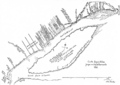
Map of Beaupré and Île d'Orléans, drawn in 1641 by Jean Bourdon
-
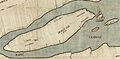
Map of the government of Quebec drawn in 1709 by Gédéon de Catalogne
-
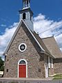
Saint-Pierre church (1717)
-
Manoir Mauvide-Genest
-
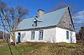
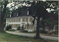
Maison Drouin in Sainte-Famille
-
A mock-up door of a make-believe l'Île-d'Orléans seigneurie
-
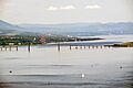
Panoramic view of the North shore, Saint-Laurent river, Île d'Orléans bridge
-
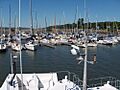
Île d'Orléans Marina
-
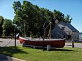
Museum La Chalouperie at "Parc maritime de Saint-Laurent" (English: Saint-Laurent Maritime Park)
-
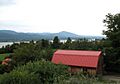
View of the north shore of the St. Lawrence River
-
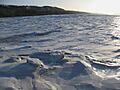
The frozen St. Lawrence River at the Île d'Orléans bridge
-
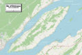
Detailed map of Île d'Orléans


.jpg)


.jpg)
.jpg)


See also
 In Spanish: Isla de Orleans para niños
