
Canadian Shield facts for kids
Quick facts for kids Canadian ShieldStratigraphic range: Precambrian 4500–540 mya |
|
|---|---|
| Type | Shield |
| Unit of | North American craton |
| Sub-units | Laurentian Upland Kazan |
| Area | 8 000 000 km2 |
| Location | |
| Region | North America |
| Country | |
 The Canadian Shield is a broad region of Precambrian rock (pictured in shades of red) that encircles Hudson Bay. It spans eastern, northeastern, and east-central Canada and the upper midwestern United States. |
|
The Canadian Shield is also known as the Laurentian Plateau. In French, it's called Bouclier canadien.
This huge area is made of very old rock from the Precambrian time. It's one of the largest and oldest parts of the Earth's crust. Think of it as the ancient heart of the North American continent.
This ancient rock also stretches into western Greenland. This is because these lands were once connected. In the United States, the Shield is mostly hidden under newer rocks and sediment. Around Hudson Bay, the Canadian Shield has thin soil. Its main use today is for mining.
Contents
How Big is the Canadian Shield?
The Canadian Shield is the largest area on Earth where Precambrian rock is visible. Some of these rocks are over 4 billion years old! It's mostly made of very old, hard rocks like igneous and metamorphic rocks.
The Shield covers about 8 million square kilometers (3 million square miles). It spreads across eastern and central Canada. This includes parts of Quebec, Ontario, Manitoba, Saskatchewan, Alberta, the Northwest Territories, and Nunavut. It also reaches into parts of the United States like Minnesota, Wisconsin, and New York.
The region often looks like a horseshoe or a shield shape. It wraps around Hudson Bay.
What Does the Landscape Look Like?
The Canadian Shield has rocky hills and many irregular basins. These basins are often filled with lakes and swamps. The land is usually between 300 to 610 meters (980 to 2,000 feet) above sea level.
During the Pleistocene Epoch, huge glaciers moved across the land. They scraped away soil and weathered rock. This is why the Shield has so many bare rock surfaces and thin soils today.
What Natural Resources Does it Have?
The Canadian Shield is very rich in valuable minerals. You can find gold, silver, copper, zinc, uranium, and iron here. Because these resources are easy to reach, mining is a very important industry in this region.
The many lakes and rivers in the Shield are also great for making hydroelectric power. Big power projects use the water at places like Churchill Falls in Labrador and James Bay in Quebec.
What Kind of Nature is There?
The Shield mostly has boreal forests. These forests are full of coniferous trees like spruce and pine. As you travel further north, the trees become smaller and eventually disappear. The land then turns into tundra because of the colder temperatures.
Who Lived Here in the Past?
The Canadian Shield has been home to many Indigenous peoples for thousands of years. Groups like the Cree, Anishinaabeg, Innu, Dene, and Inuit have lived here for a very long time.
Later, European settlers came to the area. They saw that the region had lots of wildlife, which was good for fur trading. The many waterways helped both Indigenous peoples and European explorers travel and trade easily.
The Canadian Shield is still a very important part of Canada's geography and economy. This is because of its amazing natural resources and unique environment.
Images for kids
-
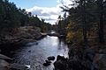
This is a typical Shield landscape in southern Ontario. There are not many old trees here because of past logging and fires. This photo is from Black River, Queen Elizabeth II Wildlands Provincial Park.
-
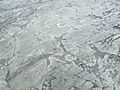
Here you can see weathered Precambrian pillow lava in the Temagami Greenstone Belt. Pillow lava forms when lava erupts underwater.
-
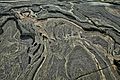
This image shows folded Precambrian gneiss rock in Georgian Bay, Ontario. The patterns were created by thousands of years of ice and water.
-
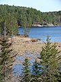
This is a typical Canadian Shield landscape. You can see spruce trees, lakes, bogs, and lots of rock.


See also
 In Spanish: Escudo Canadiense para niños
