
James Bay facts for kids
Quick facts for kids James Bay |
|
|---|---|

A satellite image of James Bay
|
|

James Bay
Location in Ontario
|
|
| Location | Southern end of Hudson Bay, between Ontario and Quebec. |
| Coordinates | 53°05′N 80°35′W / 53.083°N 80.583°W |
| Basin countries | Canada |
| Max. length | 443 km (275 mi) |
| Max. width | 217 km (135 mi) |
| Surface area | 68,300 km2 (26,400 sq mi) |
| Average depth | 60 m (200 ft) |
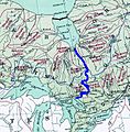
James Bay (also known as French: Baie James in French and Cree: Wînipekw in Cree) is a large body of water in Canada. It sits at the southern end of Hudson Bay. Both James Bay and Hudson Bay are connected to the Arctic Ocean. James Bay is the part that reaches furthest south.
This bay touches the Canadian provinces of Quebec and Ontario. The islands inside James Bay, like the big Akimiski Island, are part of Nunavut. Many rivers flowing into James Bay have been changed with dams to create hydroelectric power. These rivers are also popular for fun activities like canoeing. Several communities, including many Indigenous groups like the Kashechewan First Nation and the Cree people, live near James Bay.
Just like the rest of Hudson Bay, James Bay freezes over in winter. It is usually the last part of Hudson Bay to freeze and the first to melt in the summer.
Contents
History of James Bay
People have lived along the shores of James Bay for a very long time. They arrived after the huge glaciers melted about 8,150 years ago, at the end of the last ice age. Different Indigenous cultures have called this area home. When Europeans first arrived, the Indigenous people living on both sides of the bay were Cree peoples.
European Explorers Arrive
Henry Hudson was likely the first European to enter James Bay in 1610. He was exploring the larger bay that was later named after him (Hudson Bay). This southern part, James Bay, was named to honor Thomas James. He was a Welsh captain who explored the area more closely in 1630 and 1631.
James Bay is important in Canadian history. It was one of the easier parts of the Hudson Bay region to reach, even though not many people lived there. It became a key area for the Hudson's Bay Company and for British expansion into Canada.
The Hudson's Bay Company
Two fur traders, Pierre-Esprit Radisson and Médard des Groseilliers, convinced the English king, Charles II, that there was a lot of wealth in furs and minerals in the north. Des Groseilliers sailed with Captain Zachariah Gillam on a ship called the Nonsuch. Together, they started Charles Fort, which was the first European fur-trading post on James Bay.
Their trip was very successful, even though they didn't find minerals. Because of their success, King Charles II gave them a special permission to start the Hudson's Bay Company. This company was given the sole right to trade furs in the entire Hudson Bay basin, which included James Bay. At the same time, the first English colony on what is now mainland Canada, called Rupert's Land, was created. Charles Fort was its first "capital." The first governor, Charles Baley, was a Quaker. Many believe this helped him have good relationships with the First Nations people, who were the company's trading partners.
Fur trapping has continued to be important in the region for a long time. The east coast of James Bay was easier for French and other traders to reach from the south. So, the Hudson's Bay Company focused on trading with tribes in the interior, who could be reached from the west coasts of James and Hudson bays. However, the east coast was still a gateway to British settlements further west, like Winnipeg in Manitoba and even as far as the Rocky Mountains.
Geography of James Bay

James Bay is the southern part of the Arctic Archipelago Marine ecozone. The areas along the coast are mostly part of the Hudson Plains. But the northeastern coast in Quebec is part of the Taiga Shield ecozone. This eastern shore is rocky and hilly, forming the edge of the Canadian Shield in Quebec. Here, you'll find mostly boreal forest, which is a type of northern forest.
The western shore, however, has wide, flat tundra lowlands. These are an extension of the Hudson Bay Lowlands. The plants here are mostly muskeg bog, which is a wet, spongy land. A large part of this area is protected as Polar Bear Provincial Park. You can often see Ringed seals in James Bay, and polar bears hunt these seals for food. The Beluga whales living in James Bay might be a different group from those in Hudson Bay.
Hundreds of rivers flow into James Bay. Many of them share similar features. They are usually wide and shallow near the bay, in the James Bay Lowlands. But further upstream, as they flow off the Canadian Shield, they become steeper and narrower.
Hannah Bay: A Special Place
Hannah Bay is the southernmost part of James Bay. The Kesagami and Harricana Rivers flow into James Bay here. About 238 square kilometers of this area are protected as the Hannah Bay Bird Sanctuary. This sanctuary is important for birds and has been recognized as a Wetland of International Importance since 1987.
The shores in Hannah Bay have a mix of mudflats, sand, salt flats, estuaries, marshes, freshwater ponds, swamps, and forested peatlands. This variety of habitats means there is a lot of wildlife here.
Islands of James Bay
James Bay has many islands. The biggest one is Akimiski Island, which is about 3,002 square kilometers in size.
In the past, all of northern Ontario and Quebec were part of Rupert's Land, a colony owned by the Hudson Bay Company. When Canada bought Rupert's Land in 1869, the area became part of the North-West Territory. Later, in the late 1800s and early 1900s, Canada gave much of the North-West Territory to Ontario and Quebec. This created the northern parts of these provinces we know today. However, all the islands in Hudson Bay and James Bay stayed part of the North-West Territory. In 1999, after the North-West Territory was divided, these islands became part of the new territory of Nunavut.
Recreation and Canoeing
Many of the rivers that flow into James Bay are popular for wilderness canoe trips. Some of the well-known rivers include:
- Albany River (Ontario)
- Moose River (Ontario)
- Missinaibi River (Ontario)—This river is recognized as a Canadian Heritage River.
- Broadback River (Quebec)
- Rupert River (Quebec)—This river was changed in 2009 for hydroelectric power and is no longer a popular canoeing spot.
Two rivers that are less traveled are the Groundhog River and the Harricana. The Groundhog River has several dams that can make canoeing tricky. Canoeists can arrange to be driven around these dams by the dam company. The Groundhog flows into the Mattagami, which then flows into the Moose River. The Moose River starts where the Missinaibi and Mattagami rivers meet, at an island called Portage Island. This spot is about a two or three-day canoe trip to Moosonee. While the Missinaibi and Groundhog rivers usually have good water levels in summer, the Moose River can be quite low. Sometimes, groups have to walk long parts of the river, depending on the tides. The rapids on the Groundhog are often bigger and harder than those on the Missinaibi.
The Harricana River is a wild, powerful, and dangerous river. It flows into James Bay about 40 kilometers east of Moosonee. It has two very dangerous sections known as 1-mile and 7-mile island, with many rapids and waterfalls. Crossing the bay to reach this river can be very dangerous if the tides and weather are bad.
The most common starting or ending point for canoeists in this area is Moosonee, at the southern end of James Bay. There's a campsite at Tidewater Provincial Park on an island across the river from town. Water taxis can take people back and forth for about C$20. Many of these river trips end near Moosonee. From there, paddlers can take the Polar Bear Express train south to Cochrane. This train often has a special 'canoe car' for paddlers to bring their canoes.
Waskaganish, Quebec, is another town further north and east on James Bay. You can reach it by the James Bay Road. It's a common ending point for trips on the Broadback, Pontax, and Rupert rivers.
Images for kids
-
A possible plan for the GRAND Canal, showing how water might be collected and sent to Lake Huron.

.jpg)
See also
 In Spanish: Bahía James para niños
