Southern James Bay facts for kids
Quick facts for kids Southern James Bay |
|
|---|---|

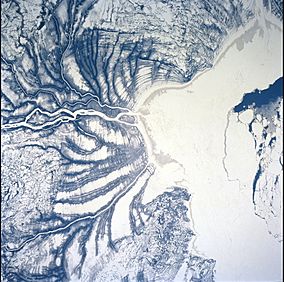
Satellite view of the frozen Hannah Bay and Harricana River
|
|
| Location | James Bay |
| Designated: | 27 May 1987 |
| Reference #: | 367 |
The Southern James Bay is a very important coastal wetland area in northeastern Ontario, Canada. It borders James Bay and the province of Quebec. This special place was recognized internationally on May 27, 1987. It was added to the Ramsar list because it's a critical spot for nature. The shallow waters of James Bay are a key stopping point for many waterbirds that fly south for the winter. These birds breed in the Arctic and need a safe place to rest and eat in late autumn.
Contents
A Special Home for Birds
This area is super important for birds, especially those that migrate. It has two main bird sanctuaries, which are like safe zones where birds can't be hunted.
Moose River Bird Sanctuary
One sanctuary is the Moose River Bird Sanctuary. It covers about 14.6 square kilometers (about 5.6 square miles). You can find it at the mouth of the Moose River. It's a busy spot for many different bird species.
Hannah Bay Bird Sanctuary
The other sanctuary is much bigger! It's called the Hannah Bay Bird Sanctuary and covers about 238.3 square kilometers (about 92 square miles). This sanctuary is on the eastern coast of Hannah Bay, right where the Harricana River flows into the bay.
Why So Many Birds?
Imagine this: up to 75,000 geese of different kinds might gather here at the same time in the autumn! You can also see huge groups of ducks. Even "diving sea ducks" are found offshore. These sanctuaries are protected areas. Hunting is not allowed inside their borders, and this rule is strictly followed. However, hunting is permitted in the areas right next to the sanctuaries.
The Land and Water
The Southern James Bay area is part of a flat, low-lying region called the Hudson Bay lowland. This whole area is part of the Hudson Plains ecozone.
What the Coast Looks Like
The coast here has a special look. It starts with wide, flat mudflats. Then, you'll find marshes that are covered by water at high tide. After that, there are "supertidal meadow-marshes" which are higher up. As you move further inland, you'll see areas with willow and alder shrubs. Beyond that, there's a drier forest mixed with wet, spongy areas called fens and bogs.
How High is the Land?
The land here is very flat. It gradually rises from the sea, but it never gets higher than about 50 meters (about 164 feet) above sea level. This low, flat landscape is perfect for the wetlands and marshes that so many birds call home.
 | Leon Lynch |
 | Milton P. Webster |
 | Ferdinand Smith |

