
Ecozone facts for kids
An ecozone (also called a biogeographic realm) is a very large area on Earth. It's like a huge natural region where plants and animals have grown and changed together over a very long time.
Imagine big parts of the world where living things developed almost on their own. These areas are separated by natural barriers like huge oceans, wide deserts, or tall mountain ranges. These barriers made it hard for plants and animals to move between ecozones. This means the living things in one ecozone are often very different from those in another.
Ecozones are special because of the unique history of their plants and animals. They are different from biomes. Biomes are areas defined by their climate and the types of plants that grow there, like a desert or a rainforest. An ecozone can actually contain many different biomes. For example, a tropical forest in South America might look similar to one in Southeast Asia, but the animals and plants living in them have very different family histories!
The way the Earth's land has moved over millions of years (called plate tectonics) has played a big role in shaping where ecozones are today.
What are Biogeographical Realms?
In 1975, a scientist named Miklos Udvardy created a system to divide the world into eight main biogeographical realms. These realms are very similar to what we now call ecozones. Udvardy wanted to help protect nature by understanding these large natural areas better.
WWF Ecozones: Earth's Natural Neighborhoods
The World Wide Fund for Nature (WWF) uses a system of eight ecozones. These are based on earlier ideas by scientists. The WWF uses these ecozones to help understand and protect the Earth's many different natural regions.
Here are the eight main WWF ecozones:
- Nearctic (22.9 million square kilometers): This ecozone covers most of North America, including places like Canada, the United States, and Mexico.
- Palearctic (54.1 million square kilometers): This is the largest ecozone. It includes most of Eurasia (Europe and Asia) and North Africa.
- Afrotropic (22.1 million square kilometers): This ecozone covers Sub-Saharan Africa, which is the part of Africa south of the Sahara Desert.
- Indomalaya (7.5 million square kilometers): This area includes the South Asian subcontinent and Southeast Asia.
- Australasia (7.7 million square kilometers): This ecozone includes Australia, New Guinea, and nearby islands. A famous natural boundary called the Wallace Line separates it from the Indomalaya ecozone.
- Neotropic (19.0 million square kilometers): This ecozone covers South America and the Caribbean islands.
- Oceania (1.0 million square kilometers): This includes many islands in the Pacific Ocean, like Polynesia, Fiji, and Micronesia.
- Antarctic (0.3 million square kilometers): This ecozone covers Antarctica, the icy continent at the South Pole.

The WWF's system is quite similar to Udvardy's. One main difference is how the Australasian ecozone is defined. In the WWF system, Australasia includes Australia, Tasmania, the islands of Wallacea, New Guinea, the East Melanesian islands, New Caledonia, and New Zealand. Udvardy's system placed some of these islands in different realms.
Images for kids
-
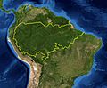
A map of the Amazon rainforest ecoregions. The yellow line encloses the ecoregions per the World Wide Fund for Nature.
-
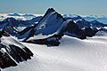
The Ötztal Alps, a mountain range in the central Alps of Europe, are part of the Central Eastern Alps, and can both be termed as ecoregions.
-
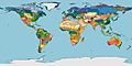
Terrestrial Ecoregions of the World (Olson et al. 2001, BioScience)
-
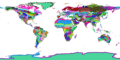
WWF terrestrial ecoregions
-
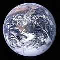
View of Earth, taken in 1972 by the Apollo 17 crew. Approximately 71% of Earth's surface (an area of some 361 million square kilometers) consists of ocean
-
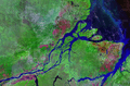
The Amazon River in Brazil.


