
Amazon River facts for kids
Quick facts for kids Amazon River |
|
|---|---|

Satellite image of the Amazon Delta
|
|

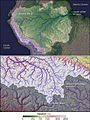
Amazon River and its drainage basin
|
|
| Other name(s) | Rio Amazonas, Río Amazonas |
| Country | Peru, Colombia, Brazil |
| Cities | Iquitos (Peru); Leticia (Colombia); Tabatinga (Brazil); Tefé (Brazil); Itacoatiara (Brazil) Parintins (Brazil); Óbidos (Brazil); Santarém (Brazil); Almeirim (Brazil); Macapá (Brazil); Manaus (Brazil) |
| Physical characteristics | |
| Main source | Apurímac River, Mismi Peak Arequipa Region, Peru 5,220 m (17,130 ft) 15°31′04″S 71°41′37″W / 15.51778°S 71.69361°W |
| River mouth | Atlantic Ocean Brazil 0°42′28″N 50°5′22″W / 0.70778°N 50.08944°W |
| Length | 3,750 km (2,330 mi)
(Amazon–Ucayali–Tambo–Ené–Apurímac 6,400 km (4,000 mi) – 6,500 km (4,000 mi) (Amazon–Marañón 5,700 km (3,500 mi) |
| Width |
|
| Depth |
|
| Discharge (location 2) |
206,000–215,000 m3/s (7,300,000–7,600,000 cu ft/s) |
| Discharge (location 3) |
|
| Discharge (location 4) |
|
| Discharge (location 5) |
105,720 m3/s (3,733,000 cu ft/s) |
| Basin features | |
| River system | Amazon River |
| Basin size | (with Tocantins)
6,743,000 km2 (2,603,000 sq mi)–7,000,000 km2 (2,700,000 sq mi) (5,956,000–6,112,000 km2 without Tocantins) |
| Tributaries |
|

The Amazon River is a giant river in South America. It is the largest river in the world by the amount of water it carries. It is also considered either the longest or the second-longest river system on Earth, a title often debated with the Nile River.
The Amazon River starts high in the Andes Mountains in Peru. It then flows across Peru, Colombia, and Brazil before emptying into the Atlantic Ocean. This mighty river and its many branches create the largest drainage basin in the world. This basin is home to the famous Amazon rainforest, which is full of amazing plants and animals.
Contents
- What's in a Name? The Story Behind "Amazon"
- A Journey Through Time: The Amazon's History
- The Amazon's Journey: From Mountains to the Ocean
- The Amazon's Huge Watershed
- The Amazon's Flow and Depth
- The Amazon's Geological Story
- Protecting the Amazon: Special Areas
- Amazing Life: Flora and Fauna of the Amazon
- Current Challenges Facing the Amazon River
- Major Rivers Flowing into the Amazon
- Images for kids
- See Also
What's in a Name? The Story Behind "Amazon"
The Amazon River was first known to Europeans as the Marañón. The name "Rio Amazonas" (Amazon River) was reportedly given after an expedition in the 1500s. During this journey, led by Francisco de Orellana, the explorers were attacked by native warriors. These warriors were led by women, which reminded de Orellana of the mythical Amazon warriors from ancient Greek stories.
Some scholars also believe the name might come from a local Tupi word, amassona, which means "boat destroyer." This name could refer to the strong currents of the river.
A Journey Through Time: The Amazon's History
How the Amazon River Changed Over Millions of Years
Scientists believe that millions of years ago, the Amazon River flowed in the opposite direction, from east to west. But then, the huge Andes Mountains began to form. These mountains blocked the river's path to the Pacific Ocean. This caused the river to change direction and start flowing east, towards the Atlantic Ocean, just as it does today.
Ancient Civilizations Along the Amazon
Long before Europeans arrived, the areas around the Amazon River were home to many complex and large indigenous societies. These groups built towns and cities. Archaeologists think that over 3 million indigenous people lived around the Amazon when the Spanish explorer De Orellana traveled there in 1541.
These ancient people were very clever. For example, on the island of Marajó, indigenous communities may have supported a population of 100,000 people. They changed the forest by carefully growing plants and using fire. By burning parts of the forest, they made the soil richer in nutrients. This created a special dark soil called terra preta de índio (Indian dark earth). This rich soil allowed them to grow enough food for their large populations.
European Explorers Discover the Amazon
In March 1500, the Spanish explorer Vicente Yáñez Pinzón was the first European known to sail up the Amazon River. He called it Río Santa María del Mar Dulce, meaning "Saint Mary River of the Sweet Sea," because of its fresh water flowing into the ocean.
Later, Francisco de Orellana was the first European to travel the entire length of the river, from its sources in the Andes to the Atlantic Ocean. During his journey, he named some of the river's branches. The name "Amazonas" is believed to come from the women warriors he encountered, reminding him of the Greek myths.
Exploring the Vast River
Many explorers followed. In 1541, Gonzalo Pizarro and Francisco de Orellana searched for a "city of gold" and "cinnamon." Orellana eventually continued down the river, discovering new lands for Spain. His journey proved that the great river could be navigated.
Later, in 1637, Portuguese explorer Pedro Teixeira was the first European to travel up the entire river. From 1648 to 1652, António Raposo Tavares led a huge expedition, exploring many of the Amazon's tributaries.
In the late 1600s, a Czech Jesuit priest named Samuel Fritz created an important map of the Amazon. He suggested that the Marañón River was the source of the Amazon.
Scientific Journeys to the Amazon
Many scientists and naturalists explored the Amazon in the 18th and 19th centuries. They studied its plants, animals, and geography. Some famous explorers include:
- Charles Marie de La Condamine (1743)
- Alexander von Humboldt (1799–1804)
- Henry Walter Bates and Alfred Russel Wallace (1848–1859)
Modern Changes and Challenges
_(14780994814).jpg)


For centuries, much of the Amazon basin remained undeveloped. This changed in the 1800s with the start of steamship navigation. The demand for natural rubber also led to a "rubber boom." Cities like Iquitos in Peru and Manaus in Brazil grew quickly. Sadly, new diseases brought by immigrants caused many deaths among the native Amazonian people during this time.
In the 20th century, Brazilian governments tried to develop the Amazon's interior. They built roads, like the Trans-Amazonian Highway. These projects aimed to bring more people and agriculture to the region. However, many of these efforts faced challenges because the rainforest ecosystem is very delicate.
Today, Manaus is the largest city on the Amazon, with a population of 1.9 million people in 2014.
A big challenge for the Amazon is the construction of dams on its tributary rivers. While the main Amazon River itself has no dams, hundreds of dams are in operation or planned on its branches. Scientists worry that these dams could harm the river's amazing biodiversity by blocking fish migration and changing the flow of nutrients.
The Amazon's Journey: From Mountains to the Ocean
Where Does the Amazon River Begin?
For a long time, people thought the Amazon started at the Nevado Mismi peak in Peru. However, a 2014 study found that the true most distant source is actually in the Mantaro River drainage, also in Peru. This means the Amazon River is even longer than previously thought!
After many rivers join, like the Mantaro, Apurímac, and Ucayali, the Amazon leaves the mountains. It then flows into the huge Amazon rainforest.
The Upper Amazon: A Network of Waterways
In Brazil, the upper part of the Amazon is often called the Solimões. This section of the river flows through Brazil, Peru, Ecuador, Colombia, and Venezuela. Many major rivers flow into the Solimões.
The river often splits into many channels, forming islands and low-lying lands called igapó. These areas are covered by water during the rainy season.
The Lower Amazon: Where Waters Meet
The Lower Amazon begins at a special place called the Meeting of Waters near Manaus. Here, the dark waters of the Rio Negro meet the sandy-colored waters of the Solimões. For several kilometers, these two rivers flow side-by-side without mixing, creating a striking sight!
Near the town of Óbidos, the river flows past cliffs. Only about 10% of the Amazon's water enters downstream of Óbidos.
The Mighty Mouth of the Amazon
The Amazon River empties into the Atlantic Ocean near the city of Belém in Brazil. The mouth of the river is incredibly wide. If you include the Pará River and the large island of Marajó, the estuary can be up to 325 km (202 mi) wide!
The Amazon pours so much fresh water into the ocean that it creates a huge plume. This plume can cover an area of up to 1.3 million square kilometers, changing the ocean's color and saltiness far out at sea. Despite this, the strong ocean waves and tides prevent the Amazon from forming a large river delta.
Why Are There No Bridges Across the Amazon?
You might wonder why there are no bridges across the entire width of the Amazon River. It's not because the river is too wide to bridge. For most of its length, the Amazon flows through dense rainforest with very few roads or cities. There's simply not much need for bridges in these remote areas. People usually cross the river by ferry.
How Long is the Amazon River? A Big Debate!
There's a long-standing debate about whether the Amazon or the Nile River is the longest river in the world. Historically, the Nile was considered the longest. However, different ways of measuring river length have led to varying results.
Some studies have claimed the Amazon is longer, with lengths reported between 6,275 km (3,899 mi) and 7,062 km (4,388 mi). Other studies, using different methods, still find the Nile to be longer. The exact length of the Amazon remains a topic of discussion among scientists.
The Amazon's Huge Watershed
The Amazon basin is the largest drainage basin in the world. It covers about 40% of South America, an area of about 7,050,000 square kilometres (2,722,020 sq mi). This vast area collects water from many rivers and streams, all flowing towards the Amazon.
Every year, during the rainy season, the river rises significantly. It floods the surrounding forests, creating what are known as várzea or "flooded forests." These flooded forests are the largest of their kind globally. In the wet season, the flooded area of the Amazon basin can grow to 350,000 km2 (140,000 sq mi).
The Amazon releases an enormous amount of fresh water into the Atlantic Ocean. It accounts for about 20% of all the fresh water that enters the world's oceans!
An interesting natural connection exists between the Amazon and the Orinoco River basins. This is the Casiquiare canal, a river that flows from the Orinoco into the Rio Negro, which then joins the Amazon. It's the largest natural river link between two major river systems on Earth.
The Amazon's Flow and Depth
The Amazon River carries an incredible amount of water. Its average discharge is about 209,000 m3/s (7,400,000 cu ft/s). This huge flow makes it the most powerful river in terms of water volume.
The Amazon is also very deep in many places. Between Manacapuru and Óbidos, its depth can be between 20 and 26 m (66 and 85 ft). In its lowest sections, the depth averages 20 to 50 m (66 to 164 ft), and can reach up to 100 m (330 ft) in some spots.
Large ocean ships can travel far up the Amazon, reaching Manaus, about 1,500 km (930 mi) from the mouth. Smaller ocean vessels can even reach Iquitos, Peru, which is 3,600 km (2,200 mi) from the sea!
During high tides, especially in late winter, the Atlantic Ocean's incoming waters create a powerful tidal bore in the Amazon delta. This wave, called the pororoca, can be up to 25 ft (7.6 m) high and travel hundreds of kilometers inland!
The Amazon's Geological Story
The Amazon River as we know it today formed over millions of years. It became a transcontinental river between 11.8 and 11.3 million years ago. Its current shape developed about 2.4 million years ago.
Long ago, the continents of Africa and South America were joined. The proto-Amazon River flowed west. When the continents split, the rising Andes Mountains blocked this flow. This turned the Amazon Basin into a huge inland sea. Over time, this sea became a massive freshwater lake. Eventually, the waters found a new path, and the Amazon began to flow eastward, creating the vast Amazon rainforest.
Scientists also discovered a large underground river, called the Hamza River, flowing beneath the Amazon.
Protecting the Amazon: Special Areas
The Amazon region has many protected areas to help save its unique environment. Here are a few examples:
| Name | Country | Coordinates | Image | Notes |
|---|---|---|---|---|
| Allpahuayo-Mishana National Reserve | Peru | 3°56′S 73°33′W / 3.933°S 73.550°W |
 |
|
| Amacayacu National Park | Colombia | 3°29′S 72°12′W / 3.483°S 72.200°W |
 |
|
| Amazônia National Park | Brazil | 4°26′S 56°50′W / 4.433°S 56.833°W |
 |
|
| Anavilhanas National Park | Brazil | 2°23′S 60°55′W / 2.383°S 60.917°W |
 |
Amazing Life: Flora and Fauna of the Amazon
The Amazon rainforest is incredibly rich in biodiversity. More than one-third of all known species in the world live here! The river itself supports thousands of fish species, crabs, algae, and turtles.
Wonderful Mammals of the Amazon

- Amazon river dolphin (Boto): This unique dolphin lives in the Amazon and Orinoco rivers. It's the largest river dolphin, growing up to 2.6 m (8.5 ft) long. Young botos are gray, but they turn pink and then white as they get older. They use echolocation to find their way and hunt in the river.
- Tucuxi: Another type of dolphin found in the Amazon basin and coastal waters.
- Amazonian manatee: Also called a "seacow," this plant-eating mammal lives only in freshwater. It is considered a vulnerable species.
- Giant otter: Known as the "river wolf," this is one of South America's top predators. Its population has decreased due to habitat loss and hunting, making it an endangered species.
Reptiles of the Amazon
_(8990193853).jpg)
The Amazon basin is home to the anaconda, one of the world's largest snakes. Anacondas spend most of their time in shallow water, with only their nostrils above the surface. Different kinds of caimans (related to alligators) and various turtles also live in the Amazon.
Diverse Fish of the Amazon


The Amazon has an amazing variety of fish, with over 5,600 known species. About fifty new species are discovered every year!
- Arapaima (Pirarucu): One of the largest freshwater fish in the world, it can grow up to 4.6 metres (15 ft) long.
- Arowana: A predatory fish, similar to the arapaima, that can reach 120 cm (47 in) in length.
- Piranha: These omnivorous fish are well-known for gathering in large schools. There are about 30 to 60 different species of piranha.
- Candirú: A type of parasitic freshwater catfish.
- Electric eel: This fish can produce strong electric shocks. More than 100 species of electric fish live in the Amazon.
- River stingrays: These unique rays are also found in the river.
- Bull shark: This shark can live in both salt and fresh water and has been found far up the Amazon River.
Tiny Life: Microbes in the Amazon
Even the smallest creatures are important! The Amazon River is home to many different kinds of freshwater microbes. These tiny living things play a big role in the river's ecosystem.
Current Challenges Facing the Amazon River
The Amazon River is crucial for over 47 million people living in its basin. However, it faces many challenges that threaten its ecosystem and the indigenous communities who depend on it.
For example, the Yanomami tribe, with about 30,000 members, struggles to protect their land and way of life. They face problems like illegal gold mining, malnutrition, and malaria.
In 2022, a severe drought in the region caused water temperatures to rise to 39.1 degrees Celsius. This led to the tragic death of 125 Amazon river dolphins. This event shows how vulnerable the river's ecosystem is to environmental changes.
In recent years, the Amazon River has experienced some of its lowest water levels in over a century. Brazil, which holds a large part of this natural treasure, is working to manage the effects of these droughts on communities and the environment. These challenges highlight the urgent need to protect the Amazon for future generations.
Major Rivers Flowing into the Amazon
The Amazon has over 1,100 tributaries, and twelve of them are over 1,500 km (930 mi) long! Here are some of the most important ones:
Longest Tributaries of the Amazon
Here is a list of some of the longest rivers in the Amazon system:
- 6,400 km (4,000 mi) (6,275 to 7,025 km (3,899 to 4,365 mi)) – Amazon, South America
- 3,250 km (2,019 mi) – Madeira, Bolivia/Brazil
- 3,211 km (1,995 mi) – Purús, Peru/Brazil
- 2,820 km (1,752 mi) – Japurá or Caquetá, Colombia/Brazil
- 2,639 km (1,640 mi) – Tocantins, Brazil
- 2,627 km (1,632 mi) – Araguaia, Brazil (tributary of Tocantins)
- 2,400 km (1,500 mi) – Juruá, Peru/Brazil
- 2,250 km (1,400 mi) – Rio Negro, Brazil/Venezuela/Colombia
- 1,992 km (1,238 mi) – Tapajós, Brazil
- 1,979 km (1,230 mi) – Xingu, Brazil
- 1,900 km (1,181 mi) – Ucayali River, Peru
- 1,749 km (1,087 mi) – Guaporé, Brazil/Bolivia (tributary of Madeira)
- 1,575 km (979 mi) – Içá (Putumayo), Ecuador/Colombia/Peru
- 1,415 km (879 mi) – Marañón, Peru
- 1,370 km (851 mi) – Teles Pires, Brazil (tributary of Tapajós)
- 1,300 km (808 mi) – Iriri, Brazil (tributary of Xingu)
- 1,240 km (771 mi) – Juruena, Brazil (tributary of Tapajós)
- 1,130 km (702 mi) – Madre de Dios, Peru/Bolivia (tributary of Madeira)
- 1,100 km (684 mi) – Huallaga, Peru (tributary of Marañón)
Images for kids
-
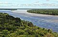
Amazon tributaries near Manaus
-
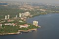
City of Manaus
-
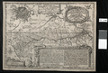
Samuel Fritz's 1707 map showing the Amazon and the Orinoco
-

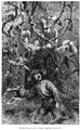
Masked-dance, and wedding-feast of Ticuna Indians, engravings for Bates's 1863 The Naturalist on the River Amazons
-
Henry Walter Bates was most famous for his expedition to the Amazon (1848–1859).
-
Amazonas state
-
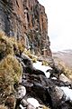
The Amazon was thought to originate from the Apacheta cliff in Arequipa at the Nevado Mismi, marked only by a wooden cross.
-
Nevado Mismi, formerly considered to be the source of the Amazon
-
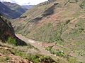
Marañón River in Peru
-
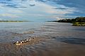
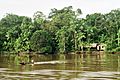
Amazon River near Iquitos, Peru
-
Meeting of Waters; the confluence of Rio Negro (blue) and Rio Solimões (sandy) near Manaus, Brazil
-
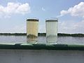
Water samples of the Solimões (right) and Rio Negro (left)
-
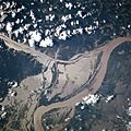
Satellite image of the mouth of the Amazon River, from the north looking south
-
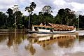
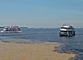
River taxi in Peru
-
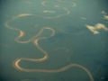
NASA satellite image of a flooded portion of the river
-
Solimões, the section of the upper Amazon River
-
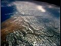
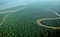
Aerial view of an Amazon tributary
-
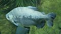
The tambaqui, an important species in Amazonian fisheries, breeds in the Amazon River.
.jpg)

.jpg)


.jpg)


See Also
 In Spanish: Río Amazonas para niños
- Amazon natural region, in Colombia
- Peruvian Amazonia in Peru
