
Amazonas (Brazil) facts for kids
Quick facts for kids
Amazonas State
Estado do Amazonas
|
|||
|---|---|---|---|
|
|||

Location of State of Amazonas in Brazil
|
|||
| Country | |||
| Capital and Largest City | Manaus | ||
| Area | |||
| • Total | 1,570,745.7 km2 (606,468.3 sq mi) | ||
| Area rank | 1st | ||
| Population
(2010 census)
|
|||
| • Total | 3,480,937 | ||
| • Rank | 15th | ||
| • Density | 2.2161047/km2 (5.7396849/sq mi) | ||
| • Density rank | 26th | ||
| Demonym(s) | Amazonense | ||
| GDP | |||
| • Year | 2006 estimate | ||
| • Total | R$ 69,166,000,000 (10th) | ||
| • Per capita | R$ 23.043 (9th) | ||
| HDI | |||
| • Year | 2006 | ||
| • Category | 0.780 – medium (13th) | ||
| Time zone | UTC-03 (UTC-4) | ||
| • Summer (DST) | UTC-02 (Brazilian DST) | ||
| Postal Code |
69000-000 to 69290-000
69400-000 to 69890-000 |
||
| ISO 3166 code | BR-AM | ||
| Website | amazonas.am.gov.br | ||


Amazonas is the largest state in Brazil. It is located in the North Region of the country. This state shares borders with other Brazilian states like Acre, Mato Grosso, Pará, Rondônia, and Roraima. It also borders several countries in Latin America.
The main city and capital of Amazonas is Manaus. You can find the highest point in Brazil here, which is called Pico da Neblina.
The name "Amazonas" comes from an old legend about the Amazons. It is also the name of the state's most important river, the Amazon River. This river is the second longest river in the entire world! Other important rivers in Amazonas include the Rio Juruá, Purus, Madeira, Rio Negro, Rio Içá, Rio Uaupés, and Rio Japurá.
The economy of Amazonas mainly relies on mining, fishing, and different types of industry.
Contents
Exploring Amazonas
Amazonas is a huge state, mostly covered by the Amazon rainforest. This makes it a very important place for nature and wildlife. Many unique plants and animals live here.
Manaus: The Capital City
Manaus is the biggest city in Amazonas. It's a busy place with a rich history. In the past, it was famous for its rubber trade. Today, it's a center for industry and tourism.
One of the most famous places in Manaus is the Amazon Theater. It's a beautiful opera house built a long time ago. Many people visit it to see its amazing architecture.
Natural Wonders
Amazonas is home to incredible natural sights.
- The Meeting of Waters is a unique spot near Manaus. Here, the dark Rio Negro meets the lighter Amazon River. Their waters flow side by side for many kilometers without mixing right away.
- The Anavilhanas National Park is another amazing place. It's a huge group of islands in the Rio Negro. It's a great spot to see the rainforest's beauty.
Culture and Festivals
The state has a vibrant culture, influenced by its indigenous people and history.
- The Parintins Folklore Festival is a very popular event. It's a colorful celebration with music, dancing, and traditional stories. People from all over Brazil come to see it.
Images for kids
-
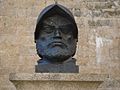
Bust of Francisco de Orellana, an explorer who visited the Amazon River
-
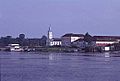
Barcelos was once an important headquarters.
-
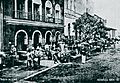
A rubber market in the center of Manaus in 1904.
-
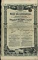
A bond from the State of Amazonas, issued in 1906.
-
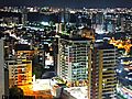
Manaus is the capital and largest city in the Amazonas State.
-
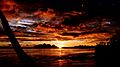
Sunset in the hill of the Six Lakes, Sao Gabriel da Cachoeira, Amazonas, Brazil.
-
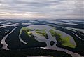
The Anavilhanas National Park is located between Manaus and Novo Airão.
-
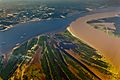
The Meeting of Waters is where two rivers meet.
-
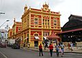
Adolpho Lisboa Municipal Market in Manaus.
-
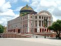
The Amazon Theater, a famous opera house.
-
The Parintins Folklore Festival is a big cultural event.
-
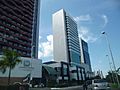
Millennium Shopping in Manaus.
-
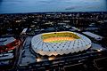
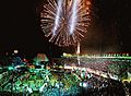
The Amazon Arena hosted games during the 2014 FIFA World Cup.


See also
 In Spanish: Amazonas (Brasil) para niños
