
Pará facts for kids
Quick facts for kids
State of Pará
|
|||
|---|---|---|---|
|
|||

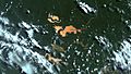
Location of State of Pará in Brazil
|
|||
| Country | |||
| Capital and Largest City | Belém | ||
| Area | |||
| • Total | 1,247,689.5 km2 (481,735.6 sq mi) | ||
| Area rank | 2nd | ||
| Population
(2012)
|
|||
| • Total | 7,792,561 | ||
| • Rank | 9th | ||
| • Density | 6.2455932/km2 (16.1760120/sq mi) | ||
| • Density rank | 21st | ||
| Demonym(s) | Paraense | ||
| GDP | |||
| • Year | 2006 estimate | ||
| • Total | R$ 44,376,000,000 (13th) | ||
| • Per capita | R$ 6,241 (22nd) | ||
| HDI | |||
| • Year | 2005 | ||
| • Category | 0.755 – medium (16th) | ||
| Time zone | UTC-3 (BRT) | ||
| Postal Code |
66000-000 to 68890-000
|
||
| ISO 3166 code | BR-PA | ||
| Website | pa.gov.br | ||


Pará is a very large state in the northern part of Brazil. It is known for its huge Amazon rainforest and many rivers. The capital city of Pará is Belém.
Pará is the second-largest state in Brazil by area. It covers a vast region of the Amazon. Many people live here, making it the ninth most populated state.
Major Cities in Pará
The capital city of Pará is Belém. It is also the largest city in the state. Belém is an important center for education and culture.
Other important cities in Pará include:
- Santarém
- Óbidos
- Anapu
Economy and Resources
Pará's economy relies a lot on its natural resources. The state is rich in minerals. For example, a lot of bauxite is mined here. Bauxite is used to make aluminum.
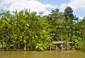
The state also has many important plants and trees. These include Brazil nut trees and açaí palm trees. Açaí berries are a popular fruit from the region.
People and Culture
The people who live in Pará are called Paraense. The state has a rich history and culture. Many different groups of people live here, including Indigenous communities. Some Indigenous groups, like the Assurini Indians, lived in isolation for a long time.
Belém is a major center for learning and culture. It has many schools and universities. The city also has beautiful buildings, like the Cathedral of Sé.
| States of Brazil | |
|---|---|
| Acre | Alagoas | Amapá | Amazonas | Bahia | Ceará | Espírito Santo | Goiás | Maranhão | Mato Grosso | Mato Grosso do Sul | Minas Gerais | Pará | Paraíba | Paraná | Pernambuco | Piauí | Rio de Janeiro | Rio Grande do Norte | Rio Grande do Sul | Rondônia | Roraima | Santa Catarina | São Paulo | Sergipe | Tocantins | |
| Federal District: Brazilian Federal District | |
Images for kids
-
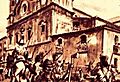
19th century engraving about the Cabanagem, a historical revolt.
-
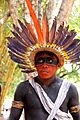
Assurini Indians lived in isolation until 1971.
-
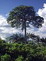
A large chestnut tree in Pará.
-
Acai trees growing in Pará.
-
Extraction of bauxite in Pará.
-
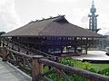
Belém is the most important education centre of the state.
-
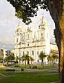
The beautiful Cathedral of Sé in Belém.
-
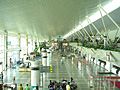
Belém International Airport.
-
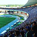
The Estádio Olímpico do Pará in Belém.


,_inside_Brazilian_Sarac%C3%A1-Taquera_National_Forest,_Par%C3%A1.jpg)


See also
 In Spanish: Pará para niños
